
Good morning folks, we’re starting out in the upper 40s and 50s for air temps and dew points, more or less, with another early-autumnal crispy start to the day, which continues to be a relief from our recent heat wave.
For our weather, we’ve got a pair of partly to mostly sunny days ahead which will feature reasonable/seasonable temps and lower humidity, to be followed by cloudier, cooler, and (at times) showery conditions Wednesday into early Thursday (especially in CMass) with warmer and more humid conditions into this coming weekend, but before we dive into all of the weather details below, let’s check a note from our local and delicious sponsor, #TandemBagelCo, with their newest location in West Springfield, MA.
——————–
A NOTE FROM OUR SPONSOR:
DHTWN Is Sponsored by Members, Patrons & Tandem Bagel Company: No matter the weather, Tandem Bagel is always there for you at several valley locations to make your mornings brighter! With bagels baked fresh daily, house-whipped cream cheese, coffee, and tons of lunch options, Tandem is the perfect quick stop for lunch, breakfast, or a coffee and bagel to go. Find them in Easthampton, Northampton, Hadley, Florence (and now West Springfield!), or use their super-streamlined online ordering tool by visiting their website: https://www.tandembagelco.com
——————————————-
***DHTWN DAILY WEATHER REPORT***
——————————————-
NWS ALERTS
–None
DHTWN REMINDER
–The odds of being a human is 1 in 400 trillion… make it count, even in a small way (see Kurt Vonnegut quote at end of post)
DAILY CELESTIAL (STAR):
–OUR STAR ROSE AT: 5:58am this morning
–OUR STAR WILL SET AT: 7:50pm this evening
–TOTAL DAYLIGHT TIME: 13 hours and 52 minutes
DAILY CELESTIAL (MOON):
–OUR MOON WILL RISE AT: 10:03pm tonight
–OUR MOON WILL SET AT: 11:08am tomorrow morning
–MOON RISE DIRECTION: East
–MOON SET DIRECTION: West
–MOON PHASE: Waning Gibbous 85.3%
———————-
DAILY TERRESTRIAL (ZoneCast)
ZONE 1 (Northern Region)
Southern VT, Southwest NH, N. Taconics NY
–High Temps: Mid 70s to Low 80s
–Low Temps: Low to Mid 50s
–Humidity: Comfortable with dewpoints in the 50s to perhaps very low 60s
–Wind: Light east wind
–Skies: Partly to Mostly Sunny
–Precipitation: A spot shower or two is possible this afternoon
ZONE 2 (Central Region)
WMass, N. CMass, N. Litchfield County, C./S. Taconics NY
–High Temps: Upper 70s to Mid 80s
–Low Temps: Mid to Upper 50s
–Humidity: Comfortable with dewpoints in the 50s to perhaps very low 60s
–Wind: Light east wind
–Skies: Partly to Mostly Sunny
–Precipitation: A spot shower or two is possible this afternoon
ZONE 3 (Southern Region)
S. CMass, S. Litchfield County, NC.CT, & NE.CT
–High Temps: Upper 70s to Mid 80s
–Low Temps: Mid to Upper 50s
–Humidity: Comfortable with dewpoints in the 50s to perhaps very low 60s
–Wind: Light east wind
–Skies: Partly to Mostly Sunny
–Precipitation: A spot shower or two is possible this afternoon
———————-
WEATHER REPORT
Good morning everybody, given that it’s Monday we gotta remember that we’re back where we started…. Here we go ’round again! Day after day we get up and we say, we gotta do it again, do it again, do it again!
#MorningKinksReference
Time to shake off the slumbah, raise those eyebrows, and do some Face Yoga if a slog faces you today, because I’m telling you, this stuff can help. Your brain needs some well-intentioned trickery to fake it until we make it type of thing, so it can sometimes say to itself “hey, if the brows are raised, and the smile is engaged and we’re breathing calmly, maybe things are going pretty well!”
Anyway, works for me when I’m down or not centered and have to get things done.
As for our weather, I’m going to start calling it the MorningBoringCast(TM) for cripes sake… we need some rain!
But it doesn’t look like we’re getting much if any this week, except for a spot shower or two today which will be very isolated so most stay dry, and then perhaps some more showers or a period of rain well east of the I-91 corridor in eastern Worcester County, NE.CT, and perhaps kissing Mt. Monadnock as a coastal low pressure system passes east of us and into the Gulf of Maine Wednesday into Thursday bringing rain to Maine, New Brunswick and Nova Scotia, most likely.
Things can change, so stay tuned for updates, but that’s how it looks as of this writing.
Normally I would say please don’t throw rotten tomatoes at the messenger, but since I just learned how to can ‘maters from my old college friends yesterday afternoon, I say to you hurl away and I’ll be ready to receive them into my well-positioned wide mouth 64 oz. Mason jars! #WinterGravy #Yum
Now enough of this nonsensical irrelevance!
On to the weather dailies we go!
For today, highs hit the mid 70s to mid 80s from SVT to NCT with most of us in the upper 70s to low 80s under mostly sunny skies, with some clouds later, and a spot shower or two possible with a light east wind.
Lows will be in the 50s, closer to 50 north and closer to 60 south under partly cloudy skies.
For Tuesday, another partly to mostly sunny day arrives, with highs in the upper 70s to mid 80s and lows in the 50s, with continued comfortable humidity, and dry conditions.
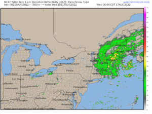
For Wednesday, we should see some scattered showers, but where they set up exactly will come down to storm track and how it interacts with an upper trough to our west, and exiting high pressure to the east.
For now, the storm continues to look like it will track east of Nantucket, but how far east, I do not know at this time. Best chance for Wednesday showers exists in Worcester County, especially eastern parts near the Worcester Metro region down into NE.CT. If the rain shield off the coast pivots SE to NW, it could kiss the Monadnock Region in SW.NH as well.
Highs will be in the low to mid 70s and I think WMass, NW.CT and S.VT just gets some scattered showers on occasion. Lows will be in the 50s with a shower possible.
By Thursday, that system will be pulling away and we should develop a mostly sunny day with highs in the mid 70s to low 80s with lows in the 50s.
Then with our Bermuda high flexing in the western Atlantic, a warmer more humid southwesterly flow setup arrives this coming weekend, with one more comfy humidity day on Friday.
Highs Friday reach the low to mid 80s, and then on Saturday and Sunday it’s the mid to upper 80s with humidity increasing, along with a chance for scattered showers and thunderstorms by Sunday afternoon, possibly occurring again on Monday.
That does it for now, my friends, I hope you have a great day!
Remember that you can also follow me on Twitter.
AND REMEMBER…
“Hello babies. Welcome to Earth. It’s hot in the summer and cold in the winter. It’s round and wet and crowded. On the outside, babies, you’ve got a hundred years here. There’s only one rule that I know of, babies: Goddamn it, you’ve got to be kind.”
–Kurt Vonnegut