
TABLE OF CONTENTS
* Daily Celestials (Sun/Moon Data)
* Sponsor Note
* Join My Newsletter
(& get my Top12WMassStorms ebook!)
* Morning Discussion
* TIP: Scroll below for sections, or read all
~~~~~~~~~~~~~~~~~~~~~~
YOUR DAILY CELESTIALS
~~~~~~~~~~~~~~~~~~~~~~
STAR:
–OUR STAR ROSE AT: 5:57am this morning
–OUR STAR WILL SET AT: 7:51pm this evening
–TOTAL DAYLIGHT TIME: 13 hours and 54 minutes
MOON:
–OUR MOON WILL RISE AT: 4:16pm this afternoon
–MOON RISE DIRECTION: Southeast
–OUR MOON WILL SET AT: 12:44am tomorrow morning
–MOON SET DIRECTION: Southwest
–MOON PHASE: Waxing Gibbous (67.9%)
~~~~~~~~~~~~~~~~~~~~~~
A NOTE FROM OUR SPONSOR
~~~~~~~~~~~~~~~~~~~~~~
Dave Hayes The Weather Nut is Sponsored by Individual Community Members, Patrons, and Tandem Bagel Company… No matter the weather, Tandem Bagel is always there for you at several valley locations to make your mornings brighter! With *New Pizza Bagels(!)*, along with bagels baked fresh daily (including Gluten-Free options), house-whipped cream cheese, coffee, and tons of lunch options, Tandem is the perfect quick stop for lunch, breakfast, or a coffee and bagel to go.
You can either 1) visit them in Easthampton, Northampton, Hadley, Florence, and/or West Springfield, 2) hire them to cater your next event, or 3) use their super-streamlined online ordering tool by visiting their website and clicking the “Catering” or “Order Online” links.
~~~~~~~~~~~~~~~~~~~~~~
DAVE’S WEEKLY NEWSLETTER (Top 12 WMass Storms)
DAVE’S MOBILE APP (Late 2024 Release)
~~~~~~~~~~~~~~~~~~~~~~
YOUR MORNING DISCUSSION
~~~~~~~~~~~~~~~~~~~~~~
Good morning folks, we’ve been enjoying a nice low humidity run as of late after the core of our soupy summer setup, and this will continue for another few days before we see a surge of muggy conditions starting Saturday, but really peaking Sunday, Monday, and very early Tuesday prior to a great Whooshening into mid week!
For today, temps start off in the 50s to low 60s and will climb into the upper 70s to mid 80s which is quite seasonable / average.
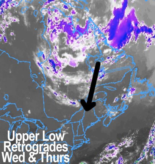
Skies will become mostly sunny after any fog burns off, but some clouds will build this afternoon as an upper low up in eastern Canada continues to slowly retrograde and track southwest towards New England.
This will help kick off a few showers in our region late this afternoon, and mostly in the hilltowns due to orographic effects.
Those should die out with the setting sun, and lows will dip into the upper 50s under partly cloudy skies.
For Thursday, highs will climb into the low to mid 80s as our upper low makes its closest swipe before being booted to the east.
As such, with a colder pool of air swiping mainly areas east of the I-91 corridor, more showers and thunderstorms get revved up due to steeper lapse rates (i.e. a sharper gradient of temps from surface to sky, or mid to upper levels).
Small hail or brief gusty winds are possible with some storms, again more likely along/east of the CT River Valley.
Activity dies down at night with lows either side of 60º, which will set us up for a lovely Friday, despite that upper low swipe also pushing through some wild fire smoke.
There are no Air Quality Alerts up yet, but I will keep an eye out.
Friday looks sunny with highs in the low to mid 80s, with dewpoints creeping up above 60º Friday night with lows in the low 60s and a shower possible.
After this brief high pressure sunnifies our Friday, another upper low (this time from the Great Lakes) will be pushing east SLOWLY, and bring more clouds to the region this weekend with periods of showers and thunderstorms at times, especially Sunday into Monday.
With more clouds around, highs will sit in the 75-80º range, and humidity will start increasing Saturday, and peak Sunday into Monday with dewpoints into the low 70s.
Again, Saturday morning looks to start off dry, but by afternoon into the night and especially Sunday and Monday we’ll see periods of showers and thunderstorms, with heavy rain for some folks. Lows will be in the 60s during this period.
Sometime around the Tuesday period, we’ll see a stronger cold front push much drier air back into our region with a final round of showers/storms, but the timing is uncertain still, so I will keep you updated. At least their’s future relief in sight!
Have a great day!
“Follow your bliss and the universe will open doors for you where there were only walls.”
― Joseph Campbell