
Good morning folks, we’re starting out out with a beautifully crisp and autumnal morning with temps in the 40s and 50s with sunny skies. Poke your head outside (or maybe your whole body!) and take a deep breath of that fresh air – what a sweet moment that is.
For our weather, we’ve got a pair of very nice days coming up followed by an unsettled period with at least cloudiness at times with some scattered showers, and possibly a steadier or heavier bout of rainfall Wednesday into early Thursday depending on a coastal storm’s track to be followed by warmer, more humid and convective weather returning into next weekend, but before we dive into all of the weather details below, let’s check a note about the Tax-Free Weekend that’s upon us from our local weekend sponsor Yankee Mattress Factory located in Agawam, MA.
——————–
A NOTE ABOUT OUR WEEKEND SPONSOR
DHTWN is sponsored by members, patrons, and Yankee Mattress Factory. Yankee Mattress is employee-owned, and mattresses are handmade locally in Agawam, MA. Several years ago I purchased a Yankee mattress and bed and was very pleased with their quality and the buying experience, which was friendly and low pressure. Tax Free weekend (Aug 13-14) is here! Go into any Yankee Mattress store to take advantage of the savings. Visit the Yankee Mattress store closest to you in Agawam, Springfield, Northampton, or Greenfield, or click for more info.
——————————————-
***DHTWN DAILY WEATHER REPORT***
——————————————-
Good morning everybody, I hope you are able to do something you love today, or at least something you are looking forward to, especially if it’s outside because the weather will be supportive of all outdoor plans this Sunday.
The congruous chunks of time that lie ahead in terms of grouping our weather impacts together into a digestible narrative are today and tomorrow, Tuesday through Thursday, and Friday through next weekend.
For today and tomorrow, we’ll still be under the influence of the Canadian high pressure that broke our heat wave from last week.
That means plenty of sunshine, low humidity, generally lighter winds, and highs in the mid 70s to low 80s both days, with lows in the low to mid 50s tonight and mid to upper 50s tomorrow night, when more clouds will be building into the region on moister southwest flow.
By Tuesday, an upper level trough will setting itself up in the northeast U.S., and this will bring more unsettled conditions with periods of cloudiness with some sunny breaks mixed in, and the chance for a few scattered showers.
In fact, we may see a few spot showers on Monday afternoon/evening as well.
Getting back to Tuesday, highs will only reach the mid to upper 70s with lows in the 50s and some additional isolated showers.
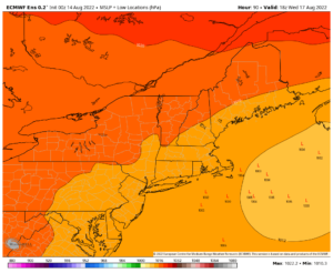
It is Wednesday and Wednesday night, possibly into early Thursday that is the timeframe we’re monitoring for some possible rain generated from a coastal storm that HOPEFULLY will come close enough to the coast to spread rainfall into our region.
The trough will be over us, and hence temps will be cool for this time of year, only climbing into the low to mid 70s for highs, and maybe some upper 60s in southern VT near places like Manchester or Townsend!
In addition, I will be monitoring to see the interaction between the upper trough and one of its waves that will round its southern flank to the coast and induce surface low storm development somewhere off of the southern New England coastline.
Some guidance shows the storm way out to Nova Scotia, others near eastern Long Island. With the position of the expected upper trough, it’s reasonable to assume (for now) that the storm will track somewhere near and likely east of Nantucket Island Wednesday afternoon and night.
This would keep the steadiest rain east of the WMass region, most likely, but could impact CMass and northeast CT, but we’ll have to watch to see if trends develop (sometimes they don’t, which makes future weather murky indeed).
The bottom line is we should expect some scattered showers anywhere in our greater WMass region Wednesday into Wednesday night, and possibly into very early Thursday morning, but the best chance for higher rain totals is in our eastern zones (CMass and NE.CT).
Lows Wednesday night will dip into the mid to upper 50s with some showers and clouds, and then after any stragglers Thursday morning, a mostly sunny day should develop with highs in the 75-80º range with lows in the 50s to near 60º.
By Friday into the weekend, a summery, more humid, warmer, convective pattern sets back up thanks to the flexing and waxing of the Bermuda high in the western Atlantic after our storm tracks well northeast of us.
Dry weather and sunny skies are expected with highs low to mid 80s Friday and mid to upper 80s into Saturday which may repeat into Sunday.
However, some long-range guidance points at another possible bout of rain, so I’ll keep an eye on that too as we head into the second half of August.
Summer is whizzing by now, folks, and daylight has sunk below 14 hours per day, so get out there and enjoy every minute than you can of it!
Have a great day! And please follow me on Twitter if you’re on it.
AND REMEMBER…
“Hello babies. Welcome to Earth. It’s hot in the summer and cold in the winter. It’s round and wet and crowded. On the outside, babies, you’ve got a hundred years here. There’s only one rule that I know of, babies: Goddamn it, you’ve got to be kind.”
–Kurt Vonnegut