>>> YOUR DAILY CELESTIALS <<<
STAR:
--OUR STAR ROSE AT: 5:52am this morning
--OUR STAR WILL SET AT: 7:58pm this evening
--TOTAL DAYLIGHT TIME: 14 hours and 6 minutes
MOON:
--OUR MOON WILL SET AT: 4:19pm this afternoon
--MOON SET DIRECTION: Northwest
--OUR MOON WILL RISE AT: 1:02am tomorrow morning
--MOON RISE DIRECTION: Northeast
--MOON PHASE: Waning Crescent (30.0%)
~~~~~~~~~~~~~~~~~~~~~~
>>> DAVE’S WEEKLY WEATHER NUTSHELL <<<
--Clouds build in after a partly sunny morning
--Continued seasonably warm temps in the 70s to low 80s
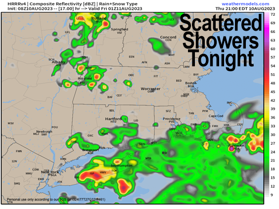
--A low pressure system passes south of us overnight, and pushes in scattered showers, and some may be heavy
--A strong to severe thunderstorm, if it forms, is more likely over northern CT into RI and southeast MA
--Showers end early Friday morning with a lovely, mostly sunny day expected, westerly gusts to 20mph or so, drier, warm
--Clear for Friday night activities, enjoy!
--Saturday morning looks quite nice for any outdoor activities, but by mid afternoon we're clouding up
--A strong low to our north draws a mid-level shortwave and front toward our region, which could spark strong to severe thunderstorms in the late afternoon and evening, into the overnight hours
--Sunday morning looks unsettled as well, prior to clearing by afternoon
--Monday is mostly sunny, with clouds increasing late, and more showers/storms Monday night into Tuesday prior to fair weather developing by the middle of next week, but before we talk details let's check a note from our local and delicious sponsor, #TandemBagelCo, with their newest location in the Stop & Shop Plaza on King Street in Northampton, MA.
~~~~~~~~~~~~~~~~~~~~~~
>>> A NOTE FROM OUR SPONSOR <<<
Dave Hayes The Weather Nut is Sponsored by Individual Community Members, Patrons & Tandem Bagel Company... No matter the weather, Tandem Bagel is always there for you at several valley locations to make your mornings brighter! With bagels baked fresh daily (including Gluten-Free options), house-whipped cream cheese, coffee, and tons of lunch options, Tandem is the perfect quick stop for lunch, breakfast, or a coffee and bagel to go. Find them in Easthampton, Northampton, Hadley, Florence, and West Springfield, or use their super-streamlined online ordering tool by visiting their website.
>>> MORNING DISCUSSION <<< Good morning everybody, as is typical, weather is always changing, and what looked like an amazing Sunday on tap is now turning a bit more unsettled for the first half of the day as the arrival of our Saturday system is delayed a bit, producing a chance for strong to severe thunderstorms Saturday evening into Sunday morning. This looks like a dynamic system, and there will likely be plenty of spin in the atmosphere, so we can't rule out a night-time tornado at this range, which would be bad news, but hopefully this threat will tamp down with the passage of time, and I will keep you updated as best I can. For today, clouds are on the increase after some partly sunny periods, with low pressure developing a bit further south than originally thought earlier this week. Highs will reach the 70s to perhaps very low 80s before topping out, and humidity will increase a bit. We'll see some scattered showers by mid to late afternoon, but heaviest rain potential likely gets pulled south of the Pike with this system as we move into the overnight hours. Flood Watches are still up for Worcester County into RI and EMass, but it's the far eastern CT into RI and southeast MA that has the highest potential for flooding rainfall, as well as a strong to severe storm capable of producing a quick, transient tornado tonight (triple T). Lows tonight drop into the 50s to low 60s, and scattered showers in the WMass region should pass through by very early Friday morning. Friday looks lovely, with sunshine developing, west winds gusting to 20mph or so, and highs in the upper 70s to low 80s with lowering humidity. Friday night looks perfect for nighttime plans with lows in the low to mid 50s under clear skies, great sleeping weather! Saturday starts off sublime, with sunshine and warming temps, but clouds will increase as a potent trough swings through southeast Canada and pushes a wave toward our region with a warm frontal boundary, set to increase humidity later in the today and especially overnight. Highs reach the low to mid 80s, and then we'll have to watch the evening for showers and storm development. As I mentioned, these warm fronts can induce spin in the lower atmosphere, and we have the potential for a strong to severe thunderstorms, and can't rule out a night-time tornado. Hopefully this potential wanes as we get closer, and I will keep you updated. Sunday morning looks unsettled with leftover showers, but the day should improve with highs either side of 80º and late-day sunshine developing, with fair weather lasting through Sunday night into Monday, which looks like a sunny day as well, again with highs either side of 80º. Then by Monday night into Tuesday a massive surge of humidity and moisture moves into the region, which could produce more of a flash flood threat with another system that gathers up that moisture and rains it out to varying degrees over our region, prior to the development of fair weather into the mid-week period. Hopefully this pattern of every other day or two becoming inclement will break soon, but for now, it's locked in. Have a great day and stay tuned for updates on Saturday night and Monday night into Tuesday potential strong weather! >>> BE KIND <<< “Hello babies. Welcome to Earth. It's hot in the summer and cold in the winter. It's round and wet and crowded. On the outside, babies, you've got a hundred years here. There's only one rule that I know of, babies: Goddamn it, you've got to be kind.” --Kurt Vonnegut
