
TABLE OF CONTENTS
* Daily Celestials (Sun/Moon Data)
* Sponsor Note
* Join My Newsletter
(& get my Top12WMassStorms ebook!)
* Morning Discussion
* TIP: Scroll below for sections, or read all
~~~~~~~~~~~~~~~~~~~~~~
YOUR DAILY CELESTIALS
~~~~~~~~~~~~~~~~~~~~~~
STAR:
–OUR STAR ROSE AT: 5:44am this morning
–OUR STAR WILL SET AT: 8:08pm this evening
–TOTAL DAYLIGHT TIME: 14 hours and 24 minutes
MOON:
–OUR MOON WILL SET AT: 6:48pm this evening
–MOON SET DIRECTION: Northwest
–OUR MOON WILL RISE AT: 3:21am tomorrow morning
–MOON RISE DIRECTION: Northeast
–MOON PHASE: Waning Crescent (9.5%)
~~~~~~~~~~~~~~~~~~~~~~
A NOTE FROM OUR SPONSOR
~~~~~~~~~~~~~~~~~~~~~~
Dave Hayes The Weather Nut is Sponsored by Individual Community Members, Patrons, and Tandem Bagel Company… No matter the weather, Tandem Bagel is always there for you at several valley locations to make your mornings brighter! With *New Pizza Bagels(!)*, along with bagels baked fresh daily (including Gluten-Free options), house-whipped cream cheese, coffee, and tons of lunch options, Tandem is the perfect quick stop for lunch, breakfast, or a coffee and bagel to go.
You can either 1) visit them in Easthampton, Northampton, Hadley, Florence, and/or West Springfield, 2) hire them to cater your next event, or 3) use their super-streamlined online ordering tool by visiting their website and clicking the “Catering” or “Order Online” links.
~~~~~~~~~~~~~~~~~~~~~~
DAVE’S WEEKLY NEWSLETTER (Top 12 WMass Storms)
DAVE’S MOBILE APP (Late 2024 Release)
~~~~~~~~~~~~~~~~~~~~~~
YOUR MORNING DISCUSSION
~~~~~~~~~~~~~~~~~~~~~~
Good morning everybody, well, I suppose that any improvement is welcome at this stage of our soupy summer, and today’s version of said improvement is a bit less humidity over the next couple of days.
Don’t get me wrong, it’ll still be plenty humid with dewpoint temps into the mid to upper 60s, but at least it won’t be into the mid to upper 70s like it was yesterday afternoon! Yuck!
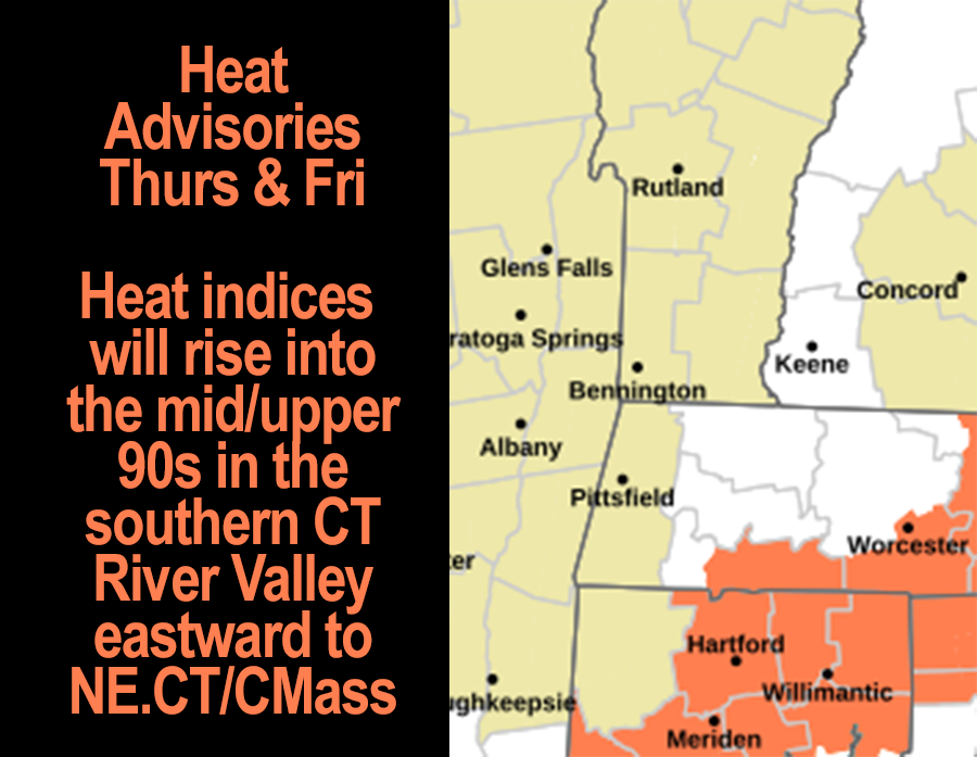
Many times in weather, what goes up most come down and vice versa, and so as dewpoints come down today, temps are going UP, with highs expected to reach the mid 80s to low 90s, which will drive heat indices into the mid to upper 90s, hence the Heat Advisory hoistings by the NWS for today and tomorrow in the southern valley of MA and CT, points east to Worcester MA / Willimantic CT.
Skies will be mostly sunny, and there will be some wild fire smoke haze as well. Lows tonight will sit down into the mid 60s under mostly clear skies.
For Friday, rinse and repeat for much of the day with highs either side of 90º with humid conditions and partly to mostly sunny skies.
A frontal boundary will be tracking northeast into the region ahead of an incoming trough that glides into the Ohio Valley. This boundary will represent a renewed surge of higher humidity and moisture into the greater WMass region.
As a result, dewpoints should come up into the mid 70s by Friday night into Saturday which is very high humidity for this region.
This will also bring some scattered showers, downpours and perhaps thunder Friday later evening into the overnight period.
Certainly, the weekend looks to feature periods of showers, downpours and some thunderstorms as it will be very humid with highs in the 80s as a trough nearby allows southerly flow into the region.
Sunday looks to be the wetter of the two and with a cold front starting to approach, I can’t rule out a strong to severe thunderstorm on Sunday.
So, expect a wet weekend overall (with some lulls for some of us, it’s not a giant rainstorm that’s incoming), which will lead us into next week when I expect a slow pattern change to develop.
To be honest, uncertainty remains for that period, but I do think temps will be lower, somewhere in the mid 70s to mid 80s, and I do think we will see some scattered showers at times, probably more numerous in the Tuesday to Wednesday timeframe ahead of a cold front that may break the back of this high humidity pattern we’ve been in.
I will refine it as we get closer, but for now, I hope you have a great day!
“Follow your bliss and the universe will open doors for you where there were only walls.”
― Joseph Campbell