
Good morning folks and I hope a good new week for you, we had showers develop overnight and quite honestly, I failed to report it yesterday morning as I took a rare day off with my sweetie and drove around southern VT. We had a lovely day and also saw that gorgeous sunset at dinner in Bennington! It was a much needed day away, and it was cool to drive around part of the northern extent of my coverage region in northern Windham and northern Bennington Counties.
We’ll see a few more morning showers today before we start to dry out. However, humidity will be increasing and by tomorrow we’ll see some more scattered showers or thunderstorms with drying by Wednesday, and then more high heat and humidity late week with a better chance for showers and storms into the first half of the weekend, but before we dive into all of the weather details below, let’s check a note from our local and delicious sponsor, #TandemBagelCo, with their newest location in West Springfield, MA.
——————–
A NOTE FROM OUR SPONSOR:
DHTWN Is Sponsored by Members, Patrons & Tandem Bagel Company: No matter the weather, Tandem Bagel is always there for you at several valley locations to make your mornings brighter! With bagels baked fresh daily, house-whipped cream cheese, coffee, and tons of lunch options, Tandem is the perfect quick stop for lunch, breakfast, or a coffee and bagel to go. Find them in Easthampton, Northampton, Hadley, Florence (and now West Springfield!), or use their super-streamlined online ordering tool by visiting their website: https://www.tandembagelco.com
——————————————-
***DHTWN DAILY WEATHER REPORT***
——————————————-
NWS ALERTS
–None
DHTWN REMINDER
–The odds of being a human is 1 in 400 trillion… make it count, even in a small way (see Kurt Vonnegut quote at end of post)
DAILY CELESTIAL (STAR):
–OUR STAR ROSE AT: 5:43am this morning
–OUR STAR WILL SET AT: 8:09pm this evening
–TOTAL DAYLIGHT TIME: 14 hours and 26 minutes
DAILY CELESTIAL (MOON):
–OUR MOON WILL SET AT: 10:23pm tonight
–OUR MOON WILL RISE AT: 10:28am tomorrow morning
–MOON SET DIRECTION: West
–MOON RISE DIRECTION: East
–MOON PHASE: Waxing Crescent 12.7%
———————-
DAILY TERRESTRIAL (ZoneCast)
ZONE 1 (Northern Region)
Southern VT, Southwest NH, N. Taconics NY
–High Temps: Low to Mid 80s
–Low Temps: Low to Mid 60s
–Humidity: Increasingly muggy with dewpoints into the 60s, and pushing into the upper 60s to low 70s tomorrow
–Wind: Light southwesterly
–Skies: Mostly cloudy early, partly sunny by afternoon
–Precipitation: Scattered morning showers dry up later this morning, then a few isolated showers in the afternoon
ZONE 2 (Central Region)
WMass, N. CMass, N. Litchfield County, C./S. Taconics NY
–High Temps: Low to Mid 80s
–Low Temps: Low to Mid 60s
–Humidity: Increasingly muggy with dewpoints into the 60s, and pushing into the upper 60s to low 70s tomorrow
–Wind: Light southwesterly
–Skies: Mostly cloudy early, partly sunny by afternoon (especially northern areas, southern areas may stay mostly cloudy)
–Precipitation: Scattered morning showers dry up later this morning, then a few isolated showers in the afternoon
ZONE 3 (Southern Region)
S. CMass, S. Litchfield County, NC.CT, & NE.CT
–High Temps: Upper 70s to Low 80s
–Low Temps: Middle 60s
–Humidity: Increasingly muggy with dewpoints into the 60s, and pushing into the upper 60s to low 70s tomorrow
–Wind: Light southwesterly
–Skies: Mostly cloudy
–Precipitation: Scattered morning showers dry up later this morning, then a few isolated showers in the afternoon
———————-
WEATHER REPORT
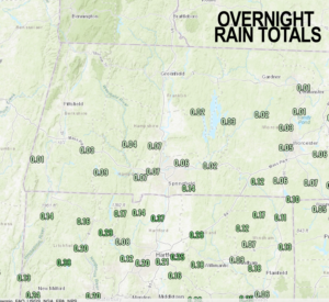
Good morning everybody, please do post any of your sunset pics from last evening below, it was certainly magical up in southwest VT over the Taconics.
As for today, we have some showers to expect this morning over the WMass region into parts of northern CT and CMass, but in the next few hours these should abate as an upper level low over us and its surface reflection tracks east.
This should leave us with a mostly cloudy day with some partial sunshine in patches this afternoon (especially the further north you go) but we can’t rule out a few isolated afternoon showers, either.
Highs will be in the upper 70s to mid 80s with light southwest flow, and humidity will be increasing into tonight and tomorrow.
Lows tonight will dip into the low to mid 60s for most of us under mostly cloudy skies with patchy fog developing late.
For Tuesday, a cold front will be moving into the region (cold fronts in the summer really should be referred to as humidity fronts, as the only thing that tends to change behind them is a lowering of humidity, though sometimes much cooler air works into behind them as well).
With southwest flow in place, we’ll be warming well into the 80s, and a few of us may touch 90º as humidity spikes toward mid day with dewpoints in the upper 60s to low 70s.
At the same time, a front will be approaching, and should spark off some scattered showers and thunderstorms. Nothing looks severe at the moment, but I will update you tomorrow morning.
By Tuesday night, we should clear things out and get perhaps 24 hours of reduced humidity, with lows dropping into the upper 50s to low 60s.
For Wednesday, we’ll have a lovely day with highs well into the 80s under mostly sunny skies, and with lows in the mid 60s as humidity builds again, and we prepare for our one-day scorch-fest on Thursday.
In fact, highs on Thursday will likely rise into the low to upper 90s with humid conditions, giving way to a few scattered showers or thunderstorms in the afternoon. Lows will drop only into the upper 60s.
By Thursday night into Friday, if the front slows down enough, we may have either a prolonged period of showers and storms, or 2 or 3 periods of them to contend with, so hopefully that comes to pass because we need more sky vapor to transform into ground water for sure.
Highs will reach the mid to upper 80s Friday, but showers and storms may linger into the night, with even additional scattered showers and thunderstorms possible for Saturday to kick off the weekend, so our rain chances are increasing a little bit compared to recent weeks, perhaps kicked off by last night’s and this morning’s emergent showers.
Highs will be in the 80s on Saturday, and then climb into the 85-90º range on Sunday, which is a day that may feature a few isolated showers, too.
Happy August to all, and allow me to remind you that next month is when the Autumn arrives. Summer moves fast now, so get out there and soak it up and enjoy it to the hilt!
Thanks for reading, have a great day, and check back with me here and on Twitter (see link below) for updates on our severe weather potential this afternoon and evening!
AND REMEMBER…
“Hello babies. Welcome to Earth. It’s hot in the summer and cold in the winter. It’s round and wet and crowded. On the outside, babies, you’ve got a hundred years here. There’s only one rule that I know of, babies: Goddamn it, you’ve got to be kind.”
–Kurt Vonnegut