
Scattered showers later tonight.
–DHTWN Reminder (Raise your ‘brows!)
–Weekly Nutshell (Quick impact list)
–Sponsor Note (Tandem Bagel Co.)
–NWS Alerts (Advisories, Warnings, Watches)
–Celestial Data (Sun/Moon info)
–Regional Summaries (Quick in/out details)
–Morning Discussion (More Details)
~~~~~~~~~~~~~~~~~~~~~~
DHTWN REMINDER: Raise your eyebrows in the face of problems.
~~~~~~~~~~~~~~~~~~~~~~
DAVE’S WEEKLY WEATHER NUTSHELL
–Sunny, 50s, breezy today with SW winds gusting 15-30mph
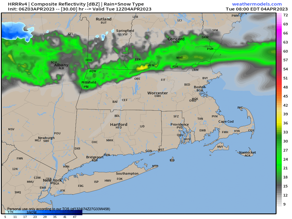
–Clouds tonight as a front drops south into MA
–Some scattered showers are expected, especially north of the Rt. 9 corridor that runs through the vertical center of MA (think northern MA, SVT, SWNH)
–Mild Tuesday with a few showers at times as a front stalls
–Highs Tues either side of 60º
–Front tracks further south Tuesday night into Wednesday, making Wednesday cooler, a few showers at times
–Confused front then says “maybe I’ll like it better north of here!” tracks north of here, warming us up into the 60s Thursday, again with a few showers early
–Better chance of widespread showers with some thunderstorms possible Thursday afternoon and evening
–Then we enter a high pressure zone (or should I say, it floats over us) for Friday through Sunday with fair weather expected for Easter Weekend, but before we jump into the weather discussion / details below, let’s check a note from our local and delicious sponsor, #TandemBagelCo, with their newest location in West Springfield, MA.
~~~~~~~~~~~~~~~~~~~~~~
A NOTE FROM OUR SPONSOR:
Dave Hayes The Weather Nut is Sponsored by Individual Community Members, Patrons & Tandem Bagel Company… No matter the weather, Tandem Bagel is always there for you at several valley locations to make your mornings brighter! With bagels baked fresh daily (including Gluten-Free options), house-whipped cream cheese, coffee, and tons of lunch options, Tandem is the perfect quick stop for lunch, breakfast, or a coffee and bagel to go. Find them in Easthampton, Northampton, Hadley, Florence, and West Springfield, or use their super-streamlined online ordering tool by visiting their website.
~~~~~~~~~~~~~~~~~~~~~~~~~~~~~~~~
***DHTWN DAILY WEATHER REPORT***
~~~~~~~~~~~~~~~~~~~~~~~~~~~~~~~~
NATIONAL WEATHER SERVICE ALERTS
–None, but elevated fire concerns exist today over northwest CT due to dry ground (away from any N. Litchfield peaks) combining with gusty wind to produce fire spread conditions
DAILY CELESTIAL (STAR):
–OUR STAR ROSE AT: 6:29am this morning
–OUR STAR WILL SET AT: 7:18pm this evening
–TOTAL DAYLIGHT TIME: 12 hours and 49 minutes
NIGHTLY CELESTIAL (MOON):
–OUR MOON WILL RISE AT: 4:50pm this afternoon
–OUR MOON WILL SET AT: 6:03am tomorrow morning
–MOON RISE DIRECTION: East-Northeast
–MOON SET DIRECTION: West
–MOON PHASE: Waxing Gibbous (92.6%)
~~~~~~~~~~~~~~~~~~~~~~~~~~~~~~~~
DAILY TERRESTRIAL
ZONE 1 – Northern Region
(Southern VT, Southwest NH)
–High Temps: Low to Mid 50s
–Low Temps: Upper 30s to Low 40s
–Winds: Southwest wind gusts 15-30mph at times
–Sky Cover: Mostly sunny, clouds tonight
–Precipitation: None today, but periods of showers later tonight
ZONE 2 – Central Region
(Western MA, North-Central MA, Northern Litchfield CT)
–High Temps: Mid to Upper 50s
–Low Temps: Low 40s
–Winds: Southwest wind gusts 15-30mph at times
–Sky Cover: Mostly sunny, clouds tonight
–Precipitation: None today, but periods of showers later tonight, especially northern half of MA
ZONE 3 – Southern Region
(South-Central MA, Northern CT)
–High Temps: Low to Mid 50s
–Low Temps: Low 40s
–Winds: Southwest wind gusts 15-30mph at times
–Sky Cover: Mostly sunny, clouds tonight
–Precipitation: None today, a few showers possible tonight
~~~~~~~~~~~~~~~~~~~~~~~~~~~~~~~~
MORNING DISCUSSION
Good morning everybody, we have a lovely and pleasant (albeit chilly) start to the work week weather-wise, with this morning in the 20s for many of us likely being the chilliest morning until the end of the week and start of the weekend.
We’ve got high pressure south of us eastwardly exiting the east coast with low pressure well north, that puts us into southwest flow today, supporting highs into the 50s for much of the region. Southwest winds will gust 15-30mph at times as a result.
As said northern low center tracks to the east, it will lay out a frontal boundary that is oriented more west to east in its axis, and that will sag southeast into our region tonight, likely slowing down and even stalling either side of the Rt. 2 corridor in northern MA.
This means clouds build tonight with lows in the upper 30s to low 40s, and some showers will develop, especially north of Rt. 9 in MA.
This front will take up an aimless disposition over coming 48 hours, dropping south, undulating north, and will make temperature forecasts tricky to pinpoint depending on its moody behavior.
Tuesday looks like a layer cake temps-wise, with 40s and 50s north of the front and 50s and 60s south of the front, with best chance of those warmer temps along and south of the Pike in MA and CT/RI.
Some scattered showers are possible at any point, but it does not look like a washout.
Lows Tuesday night will hang in the mid 40s with clouds and a few showers, and then on Wednesday the front will be forced further south, putting most if not all of us on the cool side, with highs either side of 50º, again with a few showers possible, with lows in the upper 40s.
Fog will develop Wednesday night as the front now returns as a warm front, and is expected to push northeast of us for Thursday, allowing temps to rise into the mid to upper 60s!
As the warm front works through a few showers are possible, and then for Thursday we’ll be in a moist pre-frontal air mass that should encourage further shower development, ahead of an incoming cold front for the afternoon.
This front will better focus available moisture along its boundary, and produce more widespread showers, with some downpours and/or thunderstorms possible, though for now, severe weather does not appear likely, or even probable.
That all sweeps east Thursday night, and temps bottom out into the mid 30s to low 40s with westerly flow setting up.
Friday looks blustery with west winds gusting over 30mph at times, but without a northerly component, temps should hang in the low 50s.
Wind slackens a bit by the weekend with partly to mostly sunny skies expected both days, with highs on Easter Sunday rising to either side of 60º, so we just need to get through a gloomy and at times showery stretch for the middle of this week and we’re off to the sunny races!
And of course, we have today: the only day we ever are guaranteed to have if we’re lucky enough to wake up to it, and this day in the Cosmos in the presence of our local star we’ll be supremely beautiful, so give thanks, I say, and have a great day!
BE KIND
“Hello babies. Welcome to Earth. It’s hot in the summer and cold in the winter. It’s round and wet and crowded. On the outside, babies, you’ve got a hundred years here. There’s only one rule that I know of, babies: Goddamn it, you’ve got to be kind.”
–Kurt Vonnegut