Rainy Sunday
~~~~~~~~~~~~~~~~~~~~~~
A NOTE FROM OUR SPONSOR:
Dave Hayes The Weather Nut is Sponsored by Individual Community Members, Patrons & Red Fire Farm. The Red Fire Farm store is open daily at 7 Carver Street in Granby, MA, and if you are looking for delicious organic produce, join their Summer CSA farm share. Vibrant greens, luscious heirloom tomatoes, sweet carrots and lots more to enjoy. Shares get free Pick Your Own, kicking off with strawberries in June. Add pastured eggs, local fruit & cheeses, mushrooms, pantry items, bouquets of organic flowers, and more. Weekly pickups at the Granby farm, Montague, Amherst, Forest Park/Springfield, Northampton, & Worcester (plus home delivery available), so click here today and snag your Summer Share!
~~~~~~~~~~~~~~~~~~~~~~~~~~~~~~~~
WELCOME TO DAVE HAYES THE WEATHER NUT’S RUN-ON SENTENCE EMPORIUM, PERUSE OUR EXHAUSTING-SENTENCE SELECTION, AND LET US KNOW HOW WE CAN HELP…
–That one before the sponsor block is one for the ages, I’m happy I could have served you in this way
–As for our weather, clouds continue to thicken today
–Highs have a low-chance of bursting up to near 70º if some sunny pockets open up, otherwise, upper 50s to mid 60s should do it
–First showers arrive around or after sunset
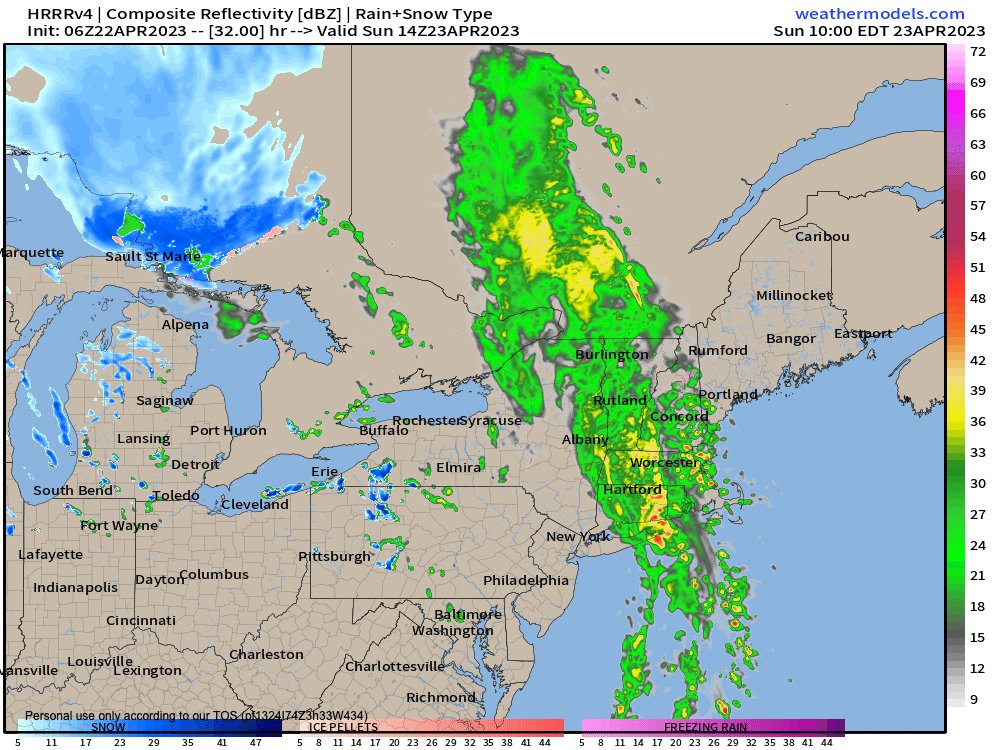
–Rain picks up in coverage and intensity after midnight, and it will rain hard at times on Sunday with deep southerly flow
–Southeast winds will gust 20-35mph later today, tonight and early Sunday
–This will help enhance rainfall over the Berkshires, western hilltowns and other east-facing slopes
–Embedded thunderstorms are expected as well, but nothing severe, just bigger rain producers
–Most areas see .75-2″ of rain, but can’t rule out some 2″+ amounts under any downpours or t-storms
–Lows tonight will be in the upper 40s with patchy fog in spots
–Sunday morning steadier rains dissipate to showers by afternoon, with highs in the mid to upper 50s #SoupMakingDay
–A few additional scattered showers are possible at night behind the cold front with lows either side of 40º
–Monday through Thursday looks to feature an upper level low pressure system that will be blocked by high pressure well to our north in eastern Canada
–This will keep a circulation over us that will swing several spokes/lobes of energy through our region
–These energy centers will combine with much colder air aloft that will produce widespread instability (meaning, air that will more freely rise due to milder air below and much colder air above, which creates buoyancy)
–This means scattered showers will be possible each day, during the days when surface heating is most pronounced
–Highs will generally be in the 50s with lows near 40º
–Some sunny breaks become more likely by mid-week
–Fair weather pushes into the region by late week into the start of next weekend with more sunshine and temps in the low 60s
–Another storm approaches for late next weekend but we’ll get there when we get there
–For now, a good soaking is set to move through overnight tonight and into Sunday, with colder than average temps expected to end April and begin May
Have a great day!
BE KIND
“Hello babies. Welcome to Earth. It’s hot in the summer and cold in the winter. It’s round and wet and crowded. On the outside, babies, you’ve got a hundred years here. There’s only one rule that I know of, babies: Goddamn it, you’ve got to be kind.”
–Kurt Vonnegut
