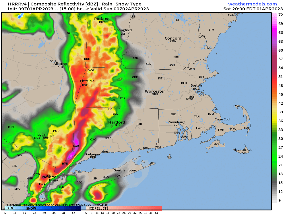
Strong to Severe T-Storms This Eve
Quickly, next week looks warmer after a cooler Sunday, and Monday looks like the pick of the week for now, with inclement weather potential for Tuedsay through Thursday, with an especially rainy and mild look for Wednesday.
Highs will be in the 50s next week, rising into the 60s by mid-week. I don’t see any severe weather potential next week, but I do see some today, especially into southern MA and northern CT, but before we jump into the weather discussion / details below, let’s check a note from our new weekend sponsor, #RerdFireFarm located in Granby, MA.
~~~~~~~~~~~~~~~~~~~~~~
A NOTE FROM OUR SPONSOR:
Dave Hayes The Weather Nut is Sponsored by Individual Community Members, Patrons & Red Fire Farm. The Red Fire Farm store is open daily at 7 Carver Street in Granby, MA, and if you are looking for delicious organic produce, join their Summer CSA farm share! Vibrant greens, luscious heirloom tomatoes, sweet carrots and lots more to enjoy. Shares get free Pick Your Own, kicking off with strawberries in June. Add pastured eggs, local fruit & cheeses, mushrooms, pantry items, bouquets of organic flowers, and more! Weekly pickups at the Granby farm, Montague, Amherst, Forest Park/Springfield, Northampton, & Worcester (plus home delivery available), so snag your Summer Share by clicking here!
~~~~~~~~~~~~~~~~~~~~~~~~~~~~~~~~
SEVERE WEATHER POTENTIAL
Ok folks, so today is our first severe weather day of our nascent Spring season, and since it’s going to be warmer this afternoon along with partly sunny skies most likely and balmy-feeling breezes out of the southwest, it’d be easy to go about your Saturday evening plans without any cares.
And while I wish I could say you should do just that, I would offer that especially if you have outside plans, it’d be wicked smaht if you had a Plan B in place to get inside, or at least an alertness this evening with an awareness of the western sky in terms of how it sounds and looks.
This is because a sharp cold front is going to be plowing into the region, and pushing through some atmospheric parameters that are favorable to help develop strong to severe storms.
Backing up, we’ve got a round of rainfall pushing through with a warm front that got hung up overnight to our south, allowing temps to hang in the 30s, and in the low 30s across northern MA, SVT and parts of SWNH, where freezing rain or drizzle likely iced a few areas.
NORTHERN ZONE FOLKS: Please let me know if you have ice accretion where you live this morning.
As the morning wears on and the sun angle increases, temps will rise with time, and rain will continue into the mid to late morning. before becoming more showery, and relenting altogether by afternoon as we enter a dry sector.
This is when skies should break to partly sunny, and if enough dry air gets in here, which it looks like it will based on water vapor imagery, we should warm well into the 60s, with a few folks possibly hitting 70!
This will help create very steep low level lapse rates (i.e. vertical temp profiles that are much cooler as you go up in elevation), which helps mix wind down, so southwesterly wind gusts up to 25mph are possible.
However, the problem is, is that we have a strong cold front mashing eastward into these steep lapse rates (both at low and mid levels).
Cold fronts are usually forcing agents that scoop air up and send it skyward.
When this forcing meets with an atmosphere that is buoyant, air can rise rapidly.
When this combines with strong wind shear (i.e. changes in wind speed with height, or direction) which is expected with this front, and there’s at least some moisture and instability present, strong to severe thunderstorms usually form.
This looks to be the case today, but the timing is good in that it’s after peak heating of the day, so that helps us hopefully see a slightly tamped down threat, but I’m not getting my hopes up yet.
MAIN THREATS AND TIMING
This squall line likely presses into the NY/CT-MA-CT state line by around 7pm, and proceeds eastward from there, moving through the Pioneer Valley between 8-9pm, then CMass by 10pm.
The main threats are torrential rainfall and pockets of straight line-wind damage, especially the further south you go (south of the Pike).
Secondary threats are the potential for an isolated tornado or two, as this system has a history of spin with it, and hail as well.
Any activity is through the region by midnight, and winds veer out of the northwest overnight, and cold air advects into the region, dropping lows into the upper 20s to low 30s with northwest gusts picking up, with a snow shower possible.
Sunday is looking much colder with highs in the upper 30s to mid 40s under mostly sunny skies with northwest gusts from 25-40mph, and lows in the 20s.
Please check back with me later today, as I will likely post a quick update sometime in the early afternoon, and will be in monitoring mode late afternoon into the evening as the squall line pushes into the region, and I will keep you updated!
Have a great day!
BE KIND
“Hello babies. Welcome to Earth. It’s hot in the summer and cold in the winter. It’s round and wet and crowded. On the outside, babies, you’ve got a hundred years here. There’s only one rule that I know of, babies: Goddamn it, you’ve got to be kind.”
–Kurt Vonnegut
