
TABLE OF CONTENTS
* Daily Celestials (Sun/Moon Data)
* Sponsor Section
* Your Short-Term ZoneCast
* Morning Discussion
~~~~~~~~~~~~~~~~~~~~~~
YOUR DAILY CELESTIALS
~~~~~~~~~~~~~~~~~~~~~~
STAR:
–OUR STAR ROSE AT: 5:51am this morning
–OUR STAR SETS AT: 7:45pm this evening
–TOTAL DAYLIGHT TIME: 13 hours and 54 minutes
MOON:
–OUR MOON ROSE AT: 5:26am this morning
–MOON RISE DIRECTION: East-Northeast
–OUR MOON SETS AT: 8:02pm tonight
–MOON SET DIRECTION: West-Northwest
–MOON PHASE: New Moon (0.2%)
~~~~~~~~~~~~~~~~~~~~~~
>>> A NOTE FROM OUR WEEKEND SPONSOR <<<
Dave Hayes The Weather Nut is Sponsored by Individual Community Members, Patrons, and Gerard, Ghazey & Bates, P.C.
GGBPC is a Northampton-based law firm and is the area’s premier estate and tax planning provider. The firm specializes in Estate Planning, Elder Law, and Tax Law, so be sure to contact GGBPC today to see how they can help you.
Simply click the following link to their secure website.
~~~~~~~~~~~~~~~~~~~~~~
YOUR SHORT-TERM ZONECAST
~~~~~~~~~~~~~~~~~~~~~~
ZONE 1 – Northern Region
(Southern VT, Southwest NH)
–Highs Today: Mid 40s to low 50s
–Lows Tonight: Upper 30s to Mid 40s
–Highs Tomorrow: Mid 60s to Low 70s
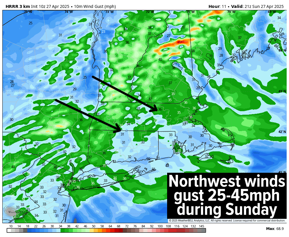
–Winds: Northwest winds gust 25-45mph today and tonight, light tomorrow
–Skies: Mostly cloudy today, clearing late tonight, sunny tomorrow
–Precip: Mixed rain and snow showers, some coatings to an inch in the mountains.
–NWS Alerts + Nut Notes: Wind chills in the 30s and 40s
ZONE 2 – Central Region
(Western MA, North-Central MA, Northern Litchfield CT)
–Highs Today: Upper 40s to Mid 50s
–Lows Tonight: Low to Mid 40s
–Highs Tomorrow: Upper 60s to Mid 70s
–Winds: Northwest winds gust 25-45mph today and tonight, light tomorrow
–Skies: Mostly cloudy today, clearing late tonight, sunny tomorrow
–Precip: Some rain showers in far northwest MA (may mix with snow at or above 2000 feet)
–NWS Alerts + Nut Notes: Wind chills in the 40s
ZONE 3 – Southern Region
(South-Central MA, Northern CT)
–Highs Today: Mid 50s
–Lows Tonight: Mid to Upper 40s
–Highs Tomorrow: Low to Mid 70s
–Winds: Northwest winds gust 25-45mph today and tonight, light tomorrow
–Skies: Partly sunny today, partly cloudy tonight, sunny tomorrow
–Precip: A few isolated morning showers possible
–NWS Alerts + Nut Notes: Wind chills in the 40s
~~~~~~~~~~~~~~~~~~~~~~
YOUR MORNING DISCUSSION
~~~~~~~~~~~~~~~~~~~~~~
Good morning everybody, I have confirmed we’ve got snow in the mountain peaks in southern VT with fresh coatings already on the ground, thanks to our unseasonable upper low pressure system parked right over the state of Vermont this morning. Upper lows produce colder air aloft and at the surface, and also create instability, allowing for shower formation, which is what we’re seeing in SVT and nearby areas this morning like the northern Berkshires or west county.
In addition, northwest winds have kicked up behind last night’s front that helped to focus and push that soaking Saturday rainfall through the greater WMass region which dropped anywhere between 0.75”-2.5” of needed sky water across the region.
These wind gusts will push 25-45mph at times today and should last into at least the first half of tonight before slackening into our Monday.
Highs on average will reach the mid 40s to mid 50s today with mixed skies and a few mixed showers in northwest MA and SVT/SWNH, and some popcorn showers in other parts of the greater WMass region.
Wind chills will dip into the 30s at times in SVT, and the 40s in MA and northern CT as well.
For tonight, gusty winds to 35mph or so will continue with lows in the upper 30s to mid 40s as skies clear.
High pressure will build into the region for the first half of our upcoming work week, with highs well into the 60s and low 70s Monday (lows in the 40s), and then well into the 70s for Tuesday (lows in the 50s, and possibly Wednesday as well.
Sunshine will abound as our cosmic corkscrew journey (CCJ) continues unabated, though a few showers are possible Tuesday night into very early Wednesday as a weak cold front works through the region.
By late week, temps should cool more into the seasonable 60s for highs as sunshine returns late Wednesday into early Friday.
Another storm may be passing northwest of us by Friday afternoon, which could push yet another frontal boundary our way with more showers possible by afternoon and evening, which may linger into Saturday.
May some thing or all the things go well for you today as we taste the long-gone Autumn season for a minute.
“Follow your bliss and the Universe will open doors for you where there were only walls.”
― Joseph Campbell