
TODAY’S NUTSHELL: Our upper low storm system that helped spark severe weather yesterday has pushed a cold front through the region and will now track east through northern New England today and tonight. This will push cooler air through aloft, helping to spark a few instability showers this afternoon, mostly north of the Pike. Fair weather develops tonight through Tuesday, with northwest wind gusts of 20-35mph tonight through Monday evening. Temps will be cooler this coming week, and I continue to a note a signal for a rainy coastal nor’easter that could produce substantial rainfall with some wind Wednesday night into early Friday morning. I can’t even rule out some wet snow in the southern Green Mountains of SVT by Thursday night!
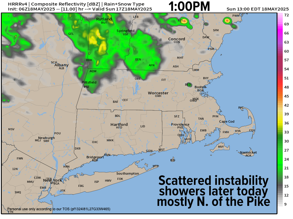
TABLE OF CONTENTS
* Daily Celestials (Sun/Moon Data)
* Sponsor Section
* Morning Discussion
~~~~~~~~~~~~~~~~~~~~~~
YOUR DAILY CELESTIALS
~~~~~~~~~~~~~~~~~~~~~~
STAR:
–OUR STAR ROSE AT: 5:26am this morning
–OUR STAR SETS AT: 8:07pm this evening
–TOTAL DAYLIGHT TIME: 14 hours and 41 minutes
MOON:
–OUR MOON SETS AT: 10:05am this morning
–MOON SET DIRECTION: West-Southwest
–OUR MOON RISES AT: 1:25am tomorrow morning
–MOON RISE DIRECTION: East-Southeast
–MOON PHASE: Waning Gibbous (70.5%)
~~~~~~~~~~~~~~~~~~~~~~
>>> A NOTE FROM OUR WEEKEND SPONSOR <<<
Dave Hayes The Weather Nut is Sponsored by Individual Community Members, Patrons, and Gerard, Ghazey & Bates, P.C.
GGBPC is a Northampton-based law firm and is the area’s premier estate and tax planning provider. The firm specializes in Estate Planning, Elder Law, and Tax Law, so be sure to contact GGBPC today to see how they can help you.
Simply click the following link to their secure website.
~~~~~~~~~~~~~~~~~~~~~~
YOUR MORNING DISCUSSION
~~~~~~~~~~~~~~~~~~~~~~
Good morning folks, thanks very much for all of your reports yesterday, and I’m glad things weren’t worse than they could have been given the few different areas of tighter rotation that developed through parts of our region yesterday afternoon.
At the peak of it there were perhaps about 4000 outages around, but service seemed to be restored fairly quickly.
As for today, we’ve got a *much* calmer and less “beautifully-creepy” sky day ahead of us, with plenty of moisture sweeping through the region as our upper low tracks east through northern New England and heads into the Canadian Maritimes by Monday.
As temps cool aloft today, rising air through this relatively moist air mass will help generate some scattered instability showers closest to the upper low center, that being mostly north of the Pike by this afternoon. No washouts are expected!
Highs will climb into the 60s, with perhaps a few upper 50s in SVT. Lows tonight as showers end will drop into the mid to upper 40s. However, northwest winds as the upper low pulls away will gust 20-35mph tonight and through Monday.
Fair weather arrives for Monday through Tuesday night, and probably through the first half of Wednesday as well.
Highs will be cooler, only reaching the low to mid 60s Monday and Tuesday under partly sunny skies with lows in the 40s, and we’ll remain dry with decreasing wind by Tuesday.
On Wednesday, temps will cool even further as our potential late-season nor’easter starts to gather itself down towards the Mid-Atlantic region. As this happens, and our upper low tracks further into the ocean, our wind will turn onshore out of the east and northeast. As such, highs will only reach the 50s on Wednesday, which is quite cool for late May!
Clouds will increase on Wednesday, and showers should arrive by sometime in the afternoon or evening, with lows dropping into the 40s as shower chances increase at night.
By Thursday, assuming the storm tracks close enough to Long Island, Block Island, Martha’s Vineyard and Nantucket, we could have a full-on rainy nor’easter with widespread steady rainfall and wind as well that could last into Thursday night and perhaps even Friday morning before dissipating.
Highs Thursday will only reach the upper 40s to mid 50s with lows in the mid 30s to low 40s, and we could even see some wet snow mix into the mountains of the southern Greens in Vermont!!
The Friday and Saturday timeframe looks a bit more murky, but could feature some scattered showers depending on how fast our system moves out of here, and temps are expected to remain cooler, in the 55-60º range for highs.
If you have any more pics or reports from yesterday please post them below, otherwise I hope you have a great day!
“Follow your bliss and the Universe will open doors for you where there were only walls.”
― Joseph Campbell