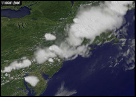
Thunderstorms form over Western Massachusetts in many different circumstances, which can lead to severe weather most often in the Summer. We can get “traditional” thunderstorms that form in the summertime ahead of strong cold fronts, which form powerful lines of storms that can sometimes result in tornados.

This NOAA satellite shot shows a severe thunderstorm line that erupted over Western Massachusetts which spawned the Springfield MA tornado in June, 2011.
WESTERN MASS HILLTOWNS THUNDERSTORMS
Just like in Winter, there are times when these storms are severe over the mountains and hilltowns, but once they reach the valley, they lose power a little bit and drop their severe characteristics. The Winter analogy is with snow squalls that die out as they cross over the valley. I believe this happens due to descending air coming off the hills. At other times, the cold front is so strong, that Western Mass gets quite literally bulldozed with severe weather, including hail, damaging gusty winds, straight line winds, and even tornados.
SQUALL LINES AHEAD OF COLD FRONTS
The most severe storms, however, are focused along and ahead of strong cold fronts that sweep into Western Massachusetts from the north and west. The change in air mass forces a more organized line of hot moist air skyward rapidly as it approaches. As this happens, squall lines of severe thunderstorms can form as they crash south and east towards our area.
CUMULONIMBUS IS MY NAME, MAKING THUNDER IS MY GAME
The cloud type associated with thunderstorms is called “Cumulonimbus”. The cumulo prefix refers to the puffy cloud type called cumulus, and the nimbus suffix means “rain” in Latin. Essentially, cumulonimbus clouds are rainy cumulus clouds. Some of these clouds can reach over 60,000 feet in height, and extend out beyond the Troposphere, through the Tropopause, and into the Stratosphere!
FORMATION
What causes thunderstorms to form? Generally, an unstable air mass. Atmospheric instability in the most basic terms, is characterized by a stronger gradient between the temperature and moisture of the air at the surface versus the upper levels of the atmosphere. Warm and hot air is less dense than cold air. Since air is cooler as you ascend through the Troposphere (i.e. the lowest section of our atmosphere up to, on average, around 40,000 feet), warm or hot moist air is buoyant and will be allowed to rise rapidly. Eventually, it condenses into cumulus clouds. When this condensation occurs, additional heat is released, causing the air to rise even further through this unstable air mass. If conditions are right, the air will rise many miles up into the atmosphere before condensing further into rain drops and falling to Earth, carrying strong downdraft winds with it. These winds slam into the surface of the planet, and radiate outwards horizontally in all directions, which if severe enough, is called a “downburst” or “microburst”.
THUNDERSTORM DEVELOPMENT PHASES
All thunderstorms, regardless of severity or size, go through three phases of development during their life cycle.
Building Phase
The first is the Building phase, where warm/hot moist air rises rapidly and condenses into cumulus clouds. As this condensation happens, more heat and energy is released, further perpetuating the formation of an updraft.
Mature Phase
The second is the Mature phase, where this ascending, condensing, and warming air accelerates and perpetuates itself, and keeps rising until it reaches a level of the same or warmer temperature. At this point, the updraft has gotten very strong. This usually occurs near the Tropopause (the boundary layer between the Troposphere and the Stratosphere). The classic anvil shaped cumulonimbus cloud pattern can form here, as the air can only spread out horizontally along this boundary. At this point, air has condensed into so much liquid water, that is falls to the Earth in a massive downdraft of rain and wind, bringing cooler air, heavy rain and strong winds to the surface.
Dissipating Phase
The third is the Dissipating phase, where the downdraft is so strong that it “rains out” the updraft by cooling the column where the updraft once occurred, and the storm begins to die out.
SUPERCELLS
In unusually large and severe thunderstorm complexes, also known as “supercells”, these complexes can develop separate and independent updrafts and downdrafts, and can perpetuate themselves for many hours. Tornados have been observed to form out of around 90% of these supercells.
