
TABLE OF CONTENTS
* Daily Celestials (Sun/Moon)
* Sponsor Section
* Morning Discussion
~~~~~~~~~~~~~~~
YOUR DAILY CELESTIALS
~~~~~~~~~~~~~~~~~~~~~~
STAR:
–OUR STAR ROSE AT: 5:13am this morning
–OUR STAR SETS AT: 8:28pm this evening
–TOTAL DAYLIGHT TIME: 15 hours and 15 minutes
***PEAK 2025 LIGHT, FOLKS***
MOON:
–OUR MOON SETS AT: 10:19am this morning
–MOON SET DIRECTION: West-Southwest
–OUR MOON RISES AT: 12:20am tomorrow morning
–MOON RISE DIRECTION: East-Southeast
–MOON PHASE: Waning Gibbous (74.7%)
~~~~~~~~~~~~~~~~~~~~~~
A NOTE FROM OUR SPONSOR
~~~~~~~~~~~~~~~~~~~~~~
Dave Hayes The Weather Nut is Sponsored by Individual Community Members, Patrons, and Tandem Bagel Company… No matter the weather, Tandem Bagel is always there for you at several valley locations to make your mornings brighter! With *New Pizza Bagels(!)*, along with bagels baked fresh daily (including Gluten-Free options), house-whipped cream cheese, coffee, and tons of lunch options, Tandem is the perfect quick stop for lunch, breakfast, or a coffee and bagel to go.
You can either 1) visit them in Easthampton, Northampton, Hadley, Florence, West Springfield, and/or Ludlow, 2) hire them to cater your next event, or 3) use their super-streamlined online ordering tool by visiting their website and clicking the “Catering” or “Order Online” links.
~~~~~~~~~~~~~~~~~~~~~~
YOUR MORNING DISCUSSION
~~~~~~~~~~~~~~~~~~~~~~
Good morning folks, we’re kicking off the work week with patchy dense fog in spots, but as temps come up, our ground clouds will evaporate back into water vapor and partly to mostly sunny skies should prevail with highs in the low to mid 70s (lows will dip to the mid to upper 50s with patchy fog possible).
Our cooler mid-June temps are partly due to a “Maritime High” cell positioned near Nova Scotia which is providing our last hours of onshore flow, which keeps the heat and humidity at bay for now.
As that high dives further south, we’ll see our flow shift from the southeast to south to southwest through Tuesday and into Wednesday.
While Tuesday will feature highs similar to today, that change in air flow will bring more moisture, more cloudiness, and increased humidity into the greater WMass region through mid-week. This change will spark some scattered showers by sometime on Tuesday, likely afternoon into the overnight period. Lows will hang in the low 60s, and humidity will be increasing.
On Wednesday, mostly cloudy skies should continue and we could see dewpoints reach the mid 60s with high temps climbing into the low 80s with some morning showers or a non-severe t-storm.
As the southwesterly heat pump gets primed, we’ll see Wednesday night lows drop into the mid to upper 60s.
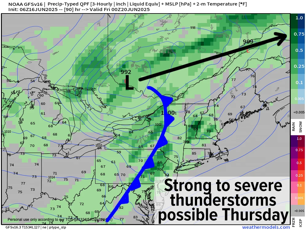
By Thursday, we will be set up for a potential of severe thunderstorms given that dewpoints will continue to climb into the upper 60s to low 70s, with air temp highs reaching the mid 80s to low 90s, with a few mid 90s readings possible in the southern CT River Valley from Springfield to Hartford.
The day should start off with more sunshine, and if we can maximize that sunshine, humidity and heat, the strong cold front that will be pushing towards New England by afternoon could spark some severe weather in the form of damaging wind gusts and/or large hail Thursday afternoon and/or evening.
Hopefully, this threat tamps down as we approach, but it’s looks pretty potent from this range, to be honest.
Behind the front, we will see drier air move into the region for Friday, and dare I say we have a decent chance at breaking our Soggy Saturday Streak?
I do dare say it. It’s a long way off, but right now high temps look to hang in the mid 70s to low 80s Friday and Saturday, and then warm up into the 80s for Sunday.
It’s looking very warm to hot next week, folks, so as our Summer Solstice swings through this Friday at night at 10:41pm, the first weekend of Summer may be a full-on winner.
Here’s hoping! Have a great day!
“Follow your bliss and the universe will open doors for you where there were only walls.”
― Joseph Campbell