
TABLE OF CONTENTS
* Daily Celestials (Sun/Moon Data)
* Sponsor Section
* Morning Discussion
~~~~~~~~~~~~~~~~~~~~~~
YOUR DAILY CELESTIALS
~~~~~~~~~~~~~~~~~~~~~~
STAR:
–OUR STAR ROSE AT: 5:13am this morning
–OUR STAR SETS AT: 8:28pm this evening
–TOTAL DAYLIGHT TIME: 15 hours and 15 minutes
***PEAK 2025 LIGHT, FOLKS***
MOON:
–OUR MOON RISES AT: 11:56pm tonight
–MOON RISE DIRECTION: East-Southeast
–OUR MOON SETS AT: 10:19am tomorrow morning
–MOON SET DIRECTION: West-Southwest
–MOON PHASE: Waning Gibbous (82.9%)
~~~~~~~~~~~~~~~~~~~~~~
>>> A NOTE FROM OUR WEEKEND SPONSOR <<<
Dave Hayes The Weather Nut is Sponsored by Individual Community Members, Patrons, and Gerard, Ghazey & Bates, P.C.
GGBPC is a Northampton-based law firm and is the area’s premier estate and tax planning provider. The firm specializes in Estate Planning, Elder Law, and Tax Law, so be sure to contact GGBPC today to see how they can help you.
Simply click the following link to their secure website.
~~~~~~~~~~~~~~~~~~~~~~
YOUR MORNING DISCUSSION
~~~~~~~~~~~~~~~~~~~~~~
Good morning everybody, we’ve got high pressure that is surrounding us from the north and the east, with some moisture pushing in from the west, which should result in mostly cloudy skies today, with perhaps a few glimpses of sun at times.
In terms of precipitation, we look mostly dry through possibly next weekend, except for the passage of a warm front Tuesday night into early Wednesday and again when a cold front moves through Thursday.
Highs today will reach the upper 60s to low 70s with lows in the mid 50s as mostly cloudy skies continue.
As high pressure drops more southeast of us, we start to warm on Monday with highs in the mid 70s or so under partly sunny skies with lows again in the 50s.
Mostly cloudy skies resume on Tuesday with highs in the mid to upper 70s as a warm front approaches the region. A few showers are possible overnight with lows in the low 60s.
By Wednesday, mostly cloudy skies are still expected, especially in the morning when a few showers are possible. By afternoon, we may see a few glimpses of sun behind the front and should see highs climb into the low to mid 80s, with lows in the mid to upper 60s as humidity increases.
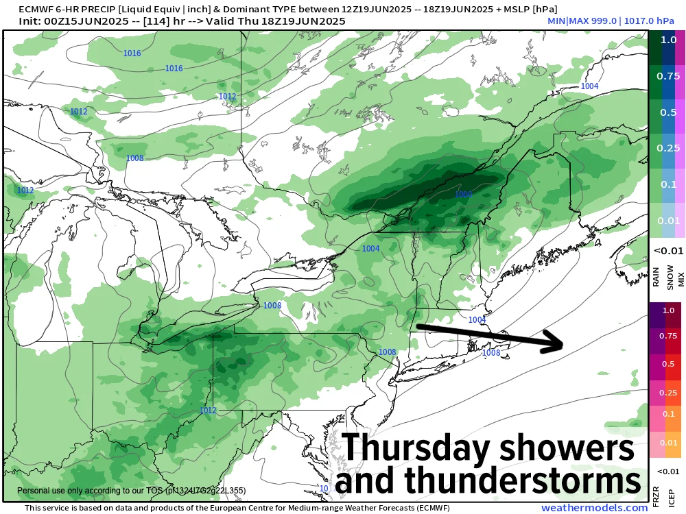
Thursday represents the peak heat and humidity in this stretch with highs in the mid 80s to low 90s and dewpoints in the mid 60s to low 70s ahead of an incoming cold front.
Assuming the timing of the front brings it through mid to later afternoon after the peak heating of the day maximizes, we could see some strong to severe thunderstorms capable of producing localized damaging wind gusts, so Thursday is the day I’m most closely watching.
Behind the front, the potential at this longer range exists for a drier air mass to move through with highs in the low 80s and partly to mostly sunny skies THROUGH the weekend, which needless to say would be beyond welcome and appreciated by so many of us after the months-long string of soggy Saturdays!
Have a great day!
“Follow your bliss and the Universe will open doors for you where there were only walls.”
― Joseph Campbell