
TABLE OF CONTENTS
* Daily Celestials (Sun/Moon)
* Sponsor Section
* Morning Discussion
~~~~~~~~~~~~~~~
YOUR DAILY CELESTIALS
~~~~~~~~~~~~~~~~~~~~~~
STAR:
–OUR STAR ROSE AT: 5:13am this morning
–OUR STAR SETS AT: 8:27pm this evening
–TOTAL DAYLIGHT TIME: 15 hours and 14 minutes
***PEAK 2025 LIGHT, FOLKS***
MOON:
–OUR MOON RISES AT: 10:54pm this evening
–MOON RISE DIRECTION: Southeast
–OUR MOON SETS AT: 7:57am tomorrow morning
–MOON SET DIRECTION: West-Southwest
–MOON PHASE: Waning Gibbous (95.4%)
~~~~~~~~~~~~~~~~~~~~~~
A NOTE FROM OUR SPONSOR
~~~~~~~~~~~~~~~~~~~~~~
Dave Hayes The Weather Nut is Sponsored by Individual Community Members, Patrons, and Tandem Bagel Company… No matter the weather, Tandem Bagel is always there for you at several valley locations to make your mornings brighter! With *New Pizza Bagels(!)*, along with bagels baked fresh daily (including Gluten-Free options), house-whipped cream cheese, coffee, and tons of lunch options, Tandem is the perfect quick stop for lunch, breakfast, or a coffee and bagel to go.
You can either 1) visit them in Easthampton, Northampton, Hadley, Florence, West Springfield, and/or Ludlow, 2) hire them to cater your next event, or 3) use their super-streamlined online ordering tool by visiting their website and clicking the “Catering” or “Order Online” links.
~~~~~~~~~~~~~~~~~~~~~~
YOUR MORNING DISCUSSION
~~~~~~~~~~~~~~~~~~~~~~
Good morning folks, we’re starting off in the 50s to low 60s, with some upper 40s in southern VT this morning, so a bit chilly up that way. We’ve got some cloudiness in place, but with high pressure nearby to our north, we’re going to stay dry today and should see some partial sunshine develop from north to south by afternoon. Highs should reach the upper 60s to mid to upper 70s with a light west wind.
For tonight, clouds will increase as a mid-level shortwave tracks into New England on Saturday, while a weak surface low passes to our south as high pressure moves into southeast Ontario and southwest Quebec.
This will cause clouds to increase early this evening with a few showers possible after say 9pm or 10pm, and especially into Saturday morning. Lows will dip into the mid to upper 50s.
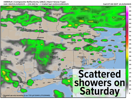
Saturday starts off showery, and temps will be cooler with highs Saturday only reaching the low to mid 60s.
As we move from the morning to afternoon on Saturday, we should see shower activity winding down from north to south as high pressure slowly presses down from the north and our disturbances kick east.
So, some showers are still possible south of the Pike in far southern MA and northern CT in the afternoon, but north of there things should be winding down as we slowly dry. Lows during our drying Saturday night should dip into the low 50s with highs on Sunday rising into the mid to upper 60s under partly sunny skies. A spot shower is possible in the afternoon, and lows will drop into the 50s.
By next week, the high pressure that dries us out later Saturday into Sunday will position itself to our south and strengthen.
This setup will produce southerly and southwesterly flow that will solidify as the week progresses.
Monday will still be cooler than average with highs in the low 70s under partly sunny skies, with lows in the upper 50s, whereas highs on Tuesday should reach to either side of 80º under partly sunny skies.
However, that influence of the southerly flow from strengthening high pressure to our south will induce a warm front to work through southern New England by Wednesday, and that is when temps will start to rise more readily.
In addition, humidity and clouds will be on the increase, and so will the chance for afternoon instability showers and thunderstorms, especially by late week.
Highs should reach the low to mid 80s by Wednesday, and then into the 85-90º range for late week with dewpoints in the low 70s, which represents very humid conditions. As a stronger shortwave approaches the region on Friday, we could spark a round of stronger showers, downpours and thunderstorms so I will keep you updated as we get closer.
Have a great day!
“Follow your bliss and the universe will open doors for you where there were only walls.”
― Joseph Campbell