
TABLE OF CONTENTS
* Daily Celestials (Sun/Moon)
* Sponsor Section
* Morning Discussion
~~~~~~~~~~~~~~~
YOUR DAILY CELESTIALS
~~~~~~~~~~~~~~~~~~~~~~
STAR:
–OUR STAR ROSE AT: 5:14am this morning
–OUR STAR SETS AT: 8:25pm this evening
–TOTAL DAYLIGHT TIME: 15 hours and 11 minutes
***We’re in the Peak Light Period of 2025***
MOON:
–OUR MOON RISES AT: 7:24pm this afternoon
–MOON RISE DIRECTION: Southeast
–OUR MOON SETS AT: 4:11am tomorrow morning
–MOON SET DIRECTION: Southwest
–MOON PHASE: Waxing Gibbous (96.6%)
~~~~~~~~~~~~~~~~~~~~~~
A NOTE FROM OUR SPONSOR
~~~~~~~~~~~~~~~~~~~~~~
Dave Hayes The Weather Nut is Sponsored by Individual Community Members, Patrons, and Tandem Bagel Company… No matter the weather, Tandem Bagel is always there for you at several valley locations to make your mornings brighter! With *New Pizza Bagels(!)*, along with bagels baked fresh daily (including Gluten-Free options), house-whipped cream cheese, coffee, and tons of lunch options, Tandem is the perfect quick stop for lunch, breakfast, or a coffee and bagel to go.
You can either 1) visit them in Easthampton, Northampton, Hadley, Florence, West Springfield, and/or Ludlow, 2) hire them to cater your next event, or 3) use their super-streamlined online ordering tool by visiting their website and clicking the “Catering” or “Order Online” links.
~~~~~~~~~~~~~~~~~~~~~~
YOUR MORNING DISCUSSION
~~~~~~~~~~~~~~~~~~~~~~
Good morning folks, we’re getting our butts in gear this morning with showers moving through the valley and temps in the 50s to low 60s, with continued compromised air quality with recent AQI readings either side of 100 so continue to take it easy if you’ve been impacted by this recent bout of Canadian wildfire smoke.
I’m admittedly no expert on exactly how smoke will travel, when it will stay aloft, when it will come to the ground, and in what concentrations, but will do my best to keep you updated on this impact. There are no Air Quality Alerts active this morning, but the Index is elevated. We may see another round of lighter smoke mid-week behind the Tuesday night frontal passage as well.
As for our weather, we’re kind of in the doldrums right now, with no real wind-steering flow to clear us out of this rather cloudy and unsettled setup.
That should change by tomorrow night into Wednesday, but before then we’ve got a few scattered showers to deal with today and tonight, with dry periods in between. Highs will only reach the mid 60s to low 70s under mostly cloudy skies, with lows in the upper 50s.
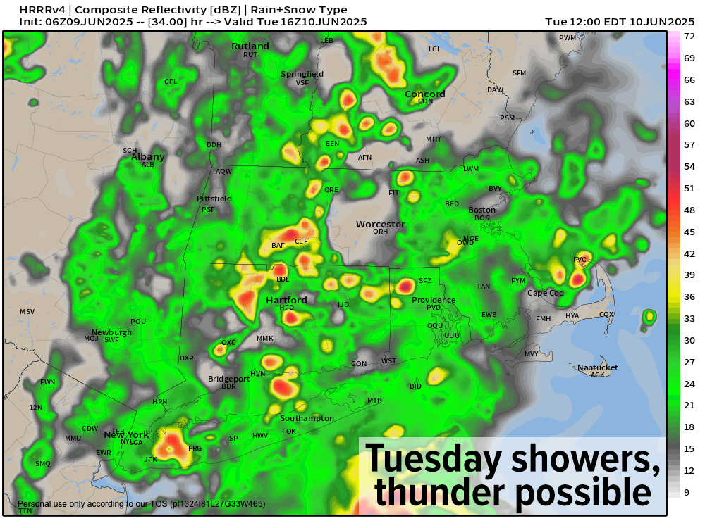
By Tuesday, I’ll be watching a warm front sweep toward New England along with a low level jet streak, both of which will help develop more widespread showers with some embedded thunderstorms and downpours, starting about mid-morning to noon, and lasting into a good portion of the afternoon.
Some street flooding is possible in heavier downpours, but flash flooding is not expected, and rain totals should roughly fall in a range of about a third of an inch to about an inch.
Highs Tuesday will rise into the low to mid 70s with lows in the 50s and a chance for patchy fog as we clear out behind the front, which may deliver some final showers toward midnight.
Wednesday and Thursday look much better, sunnier, and warmer with highs in the upper 70s to mid 80s and lows in the low 60s as high pressure builds into the region. Friday looks good at the moment, too, but should be a bit cooler with highs in the 70s under partly sunny skies.
Then we turn to next weekend when yet another disturbance will be tracking east-southeast out of the lower Great Lakes region.
High pressure will be positioned in southern Canada and this *may* help to suppress much of the shower activity associated with that disturbance to the south of the greater WMass region, but I will keep you updated. Here’s hoping!
Have a great day!
“Follow your bliss and the universe will open doors for you where there were only walls.”
― Joseph Campbell