
YOUR NUTSHELL: A strong thunderstorm that impacted parts of Franklin County and northern CMass is exiting the Lunenburg area with large hail possible. That cell moves out, and then we prime the pumps today with a stalling frontal boundary and a shortwave that moves along it. With lower amounts of wind shear, we’ll have enough wind flow to generate strong to severe storms capable of localized wind damage, and not enough to keep storms moving, which will result in slower-moving downpours capable of producing flash flooding and street flooding with torrential rain. The timeframe is that a scattered shower is possible whenever, but this heavier activity is due to impact us generally in the afternoon and evening, but especially 3-9pm in the greater WMass region. Things abate overnight, but then more showers with a couple non-severe t-storms move through Saturday and exit by about 4pm, though I will try to dial that in early tomorrow morning. Sunday and Monday are sweet and sunny, Tuesday is showery with a warm front, then warmer and drier conditions arrive mid to late next week. Details below!
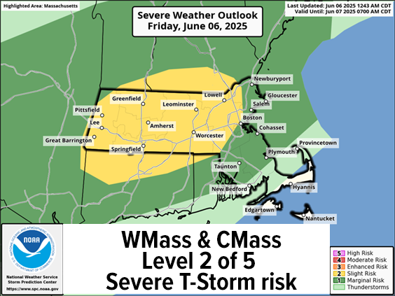
TABLE OF CONTENTS
* Daily Celestials (Sun/Moon)
* Sponsor Section
* Morning Discussion
~~~~~~~~~~~~~~~
YOUR DAILY CELESTIALS
~~~~~~~~~~~~~~~~~~~~~~
STAR:
–OUR STAR ROSE AT: 5:15am this morning
–OUR STAR SETS AT: 8:23pm this evening
–TOTAL DAYLIGHT TIME: 15 hours and 8 minutes
MOON:
–OUR MOON RISES AT: 4:12pm this afternoon
–MOON RISE DIRECTION: East-Southeast
–OUR MOON SETS AT: 2:44am tomorrow morning
–MOON SET DIRECTION: West-Southwest
–MOON PHASE: Waxing Gibbous (79.8%)
~~~~~~~~~~~~~~~~~~~~~~
A NOTE FROM OUR SPONSOR
~~~~~~~~~~~~~~~~~~~~~~
Dave Hayes The Weather Nut is Sponsored by Individual Community Members, Patrons, and Tandem Bagel Company… No matter the weather, Tandem Bagel is always there for you at several valley locations to make your mornings brighter! With *New Pizza Bagels(!)*, along with bagels baked fresh daily (including Gluten-Free options), house-whipped cream cheese, coffee, and tons of lunch options, Tandem is the perfect quick stop for lunch, breakfast, or a coffee and bagel to go.
You can either 1) visit them in Easthampton, Northampton, Hadley, Florence, West Springfield, and/or Ludlow, 2) hire them to cater your next event, or 3) use their super-streamlined online ordering tool by visiting their website and clicking the “Catering” or “Order Online” links.
~~~~~~~~~~~~~~~~~~~~~~
YOUR MORNING DISCUSSION
~~~~~~~~~~~~~~~~~~~~~~
Good morning folks, we had a real banger this morning near Athol, eastern Franklin County and through northern CMass, which is now largely passed east and is dumping hail near Shirley – fun times!
Through about early afternoon, we’ll be dealing with mostly dry conditions, though some scattered showers will hit or miss in this humid and warm air mass we find ourselves swimming through.
Highs today will reach the low to mid 80s with dewpoints in the 60s, a warm, humid, summer day is on tap, and one I think holds the strong potential to drench some towns in our region with slow-moving torrential downpours and thunderstorms. In addition, we’re under a Level 2 of 5 Severe Storm Risk published by the great folks in the Storm Prediction Center out of Norman, OK.
While hail is certainly possible (especially south of the Pike later this afternoon), it is locally damaging strong wind gusts that could cause damage or isolated power outages, as storms look to “stand up” later today.
Aside from the severe storm / wind risk, we’ve got Flood Watches hoisted for all of WMass and CMass, and now even southwest NH (southern VT may see them go up as well), for slow-moving, torrential downpours and thunderstorms.
Some of these cells could drop 1-2” of rain in a short time, maybe even more, so the localized flash flooding risk and street flooding issues are what I am more concerned about than the wind gust risk, but that’s on the table too.
The main timeframe for the strongest activity is about 2 to 3pm onward until about 9pm, give or take.
I will be on top of this all day and will be posting a mid-day report, and subsequent ongoing reporting later this afternoon.
Activity will die down late tonight with a few scattered showers around and past midnight with lows in the low 60s with patchy fog possible.
For Saturday, we have the actual cold front set to finally move through our region by afternoon, which will produce more scattered showers, with some garden variety thunderstorms.
The timing of when the heaviest activity is still not totally clear, unfortunately, but may not come through the region until about mid-afternoon tomorrow, so I will try to dial that in as we get closer.
I understand there are lot of events going on this weekend, and I wish the weather was more cooperative, and that I could dial things in for you, but in terms of Saturday, the guidance is conflicted and I can only tell you that anytime Saturday morning until about 4pm, we could (and probably will) see scattered showers of varying intensity, so don some rain gear, is my only advice.
Highs Saturday will be mostly in the 70s to near 80º, with lows in the upper 50s as we clear out.
Sunday and Monday looks lovely, with high pressure building in from Ontario, Canada with partial sunshine and highs in the mid to upper 70s and lows in the mid to upper 50s, couldn’t ask for nice weather in my opinion.
We’ll watch a warm front approach the region on Tuesday which will bring some showers, but washout is not expected at this time, with highs in the low to mid 70s and lows in the 50s.
This will lead to a warmer and sunnier Wednesday and Thursday the way it looks now with highs either side of 80º, so we just gotta get through today and tomorrow and things are looking better going forward!
Stay hydrated today folks, take it easy, and have a great day!
“Follow your bliss and the universe will open doors for you where there were only walls.”
― Joseph Campbell