
YOUR NUTSHELL: Wildfire smoke from Canada has finally arrived today and will persist through tonight and tomorrow. Air Quality Alerts are up for northern CT, and may go up later for WMass, and you may smell smoke. Sensitive folks should take it easy today, as temps are going to rise into the mid to upper 80s with the beginning of muggy feel under hazy sunshine. Hazy, hot and humid Thursday with temps in the low 90s and a few isolated showers or storm, begets more scattered to even widespread showers with some downpours and thunderstorms Friday into Saturday as a front slows down over the region. A few showers Sunday leads to drying by afternoon or night, into Monday with cooler temps. More showers are possible by Tuesday into Tuesday night.
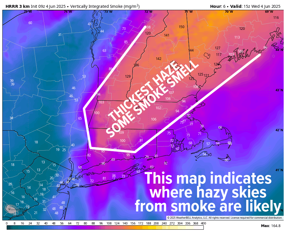
TABLE OF CONTENTS
* Daily Celestials (Sun/Moon)
* Sponsor Section
* Morning Discussion
~~~~~~~~~~~~~~~
YOUR DAILY CELESTIALS
~~~~~~~~~~~~~~~~~~~~~~
STAR:
–OUR STAR ROSE AT: 5:15am this morning
–OUR STAR SETS AT: 8:22pm this evening
–TOTAL DAYLIGHT TIME: 15 hours and 7 minutes
MOON:
–OUR MOON RISES AT: 2:09pm this afternoon
–MOON RISE DIRECTION: East
–OUR MOON SETS AT: 2:06am tomorrow morning
–MOON SET DIRECTION: West
–MOON PHASE: Waxing Gibbous (62.8%)
~~~~~~~~~~~~~~~~~~~~~~
A NOTE FROM OUR SPONSOR
~~~~~~~~~~~~~~~~~~~~~~
Dave Hayes The Weather Nut is Sponsored by Individual Community Members, Patrons, and Tandem Bagel Company… No matter the weather, Tandem Bagel is always there for you at several valley locations to make your mornings brighter! With *New Pizza Bagels(!)*, along with bagels baked fresh daily (including Gluten-Free options), house-whipped cream cheese, coffee, and tons of lunch options, Tandem is the perfect quick stop for lunch, breakfast, or a coffee and bagel to go.
You can either 1) visit them in Easthampton, Northampton, Hadley, Florence, West Springfield, and/or Ludlow, 2) hire them to cater your next event, or 3) use their super-streamlined online ordering tool by visiting their website and clicking the “Catering” or “Order Online” links.
~~~~~~~~~~~~~~~~~~~~~~
YOUR MORNING DISCUSSION
~~~~~~~~~~~~~~~~~~~~~~
Good morning everybody, buh-bye upper low, hello upper high/ridge! Also, please say hello to Canadian wildfire smoke #Booooooooo. Some of us will smell it today, and Air Quality Alerts are up for all of northern CT, and may be expanded northward into MA by the MassDEP, but for now the main impact is that our skies will be thick with smoke haze, dimming a mostly sunny sky.
In addition, pine pollen grains are in the process of peaking in this weather as well, so it’s a bit of a potpourri of pulmonary problems over the next couple of days before the rain and changing air currents can knock stuff down and sweep stuff out.
We’ll be dry for today, and dewpoints will be on the rise but not as uncomfortable as tomorrow and Friday. Highs will reach the mid to upper 80s today, with lows in the low 60s. Air quality issues likely continue tonight.
For Thursday, peak heat and humidity for this first real summer surge arrives, pushing high temps into the mid 80s to low 90s, with some mid 90s possible in the southern CT River Valley (Springfield/Hartford). We should still be dealing with some hazy sunshine, as well, and some isolated showers and thunderstorms (especallly in northwest MA into SVT) are also possible late in the afternoon or evening. Lows will dip into the mid to upper 60s, so it’ll be quite mild at night.
By Friday into Saturday, a frontal boundary will moving towards our region, but it will get hung up over southern New England, and that means a prolonged period of cloudier skies, along with periods of showers, some downpours, and a few thunderstorms mixed in as well.
We’ll have to see where the exact front placement ends up along with its speed, but while it won’t be a soaking rainfall for today, there will be scattered areas of activity, and periods of rain with highs on Friday in the low to mid 80s, and only in the low to mid 70s on Saturday. Our corresponding lows will drop into the low 60s Friday night, and then low 50s by Saturday night.
By Sunday morning, we may have some lingering showers to contend with, but that front should be making its way through, with drier conditions and partly sunny skies by Sunday afternoon with highs in the mid to upper 70s and lows in the 50s.
We’re generally in the 75-80º early to mid next week, and while some sunshine is expected on Monday, more showers from another front will probably move in by next Tuesday and Tuesday night.
Have a great day, and may good things come your way!
“Follow your bliss and the universe will open doors for you where there were only walls.”
― Joseph Campbell