
TODAY’S NUTSHELL: We continue to be stuck between a stalled upper low to our southwest, and a slowing high pressure area in Atlantic Canada. Both contribute to south-southeasterly ocean flow which will produce periods of showers at times today, with a chance for heavier rain tonight into Tuesday along with a thunderstorm. The upper low swings through Wednesday with more showers and storms accompanied by small hail/graupel. We then hope to get a break by Thursday followed by the potential for more rain Friday and Saturday with up to half a FOOT of rain possible for some by Saturday night, if the weekend storm sets up.
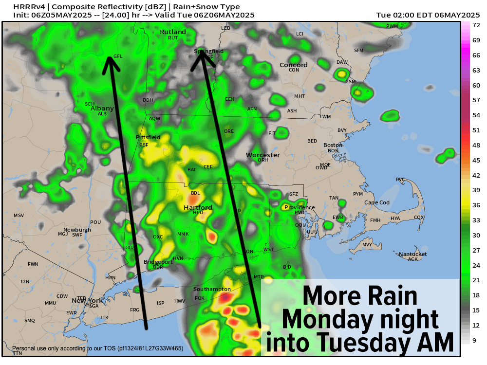
TABLE OF CONTENTS
* Daily Celestials (Sun/Moon)
* Sponsor Section
* Your Short-Term ZoneCast
* Morning Discussion
~~~~~~~~~~~~~~~
YOUR DAILY CELESTIALS
~~~~~~~~~~~~~~~~~~~~~~
STAR:
–OUR STAR ROSE AT: 5:40am this morning
–OUR STAR SETS AT: 7:54pm this evening
–TOTAL DAYLIGHT TIME: 14 hours and 14 minutes
MOON:
–OUR MOON RISES AT: 1:09pm this morning
–MOON RISE DIRECTION: East-Northeast
–OUR MOON SETS AT: 3:06am tomorrow morning
–MOON SET DIRECTION: West-Northwest
–MOON PHASE: Waxing Gibbous (59.0%)
~~~~~~~~~~~~~~~~~~~~~~
A NOTE FROM OUR SPONSOR
~~~~~~~~~~~~~~~~~~~~~~
Dave Hayes The Weather Nut is Sponsored by Individual Community Members, Patrons, and Tandem Bagel Company… No matter the weather, Tandem Bagel is always there for you at several valley locations to make your mornings brighter! With *New Pizza Bagels(!)*, along with bagels baked fresh daily (including Gluten-Free options), house-whipped cream cheese, coffee, and tons of lunch options, Tandem is the perfect quick stop for lunch, breakfast, or a coffee and bagel to go.
You can either 1) visit them in Easthampton, Northampton, Hadley, Florence, and/or West Springfield, 2) hire them to cater your next event, or 3) use their super-streamlined online ordering tool by visiting their website and clicking the “Catering” or “Order Online” links at https://www.tandembagelco.com
~~~~~~~~~~~~~~~~~~~~~~
YOUR SHORT-TERM ZONECAST
~~~~~~~~~~~~~~~~~~~~~~
ZONE 1 – Northern Region
(Southern VT, Southwest NH)
–Highs Today: 50s, possibly dropping into 40s in SWNH
–Lows Tonight: Mid 40s to Low 50s
–Highs Tomorrow: Low to Mid 60s
–Winds: Easterly gusts 15-30mph today and tonight, light SE tomorrow
–Skies: Overcast through tomorrow
–Precip: Periods of rain today and tonight, heavier tonight into Tuesday with thunder possible
–NWS Alerts + Nut Notes: Patchy fog is possible, as is isolated street flooding and isolated flash flooding overnight as rain gets heavier at times
ZONE 2 – Central Region
(Western MA, North-Central MA, Northern Litchfield CT)
–Highs Today: Mid 50s to Low 60s (cooling to near 50º in northern CMass late)
–Lows Tonight: Mid 40s to Low 50s
–Highs Tomorrow: Low to Mid 60s
–Winds: Easterly gusts 15-30mph today and tonight, light SE tomorrow
–Skies: Overcast through tomorrow
–Precip: Periods of rain today and tonight, heavier tonight into Tuesday with thunder possible
–NWS Alerts + Nut Notes: Patchy fog is possible, as is isolated street flooding and isolated flash flooding overnight, with best chance in the western hilltowns / east slopes of the Berkshires
ZONE 3 – Southern Region
(South-Central MA, Northern CT)
–Highs Today: Mid 50s to Mid 60s
–Lows Tonight: Upper 40s to Mid 50s
–Highs Tomorrow: Low to Mid 60s
–Winds: Easterly gusts 15-30mph today and tonight, light SE tomorrow
–Skies: Overcast through tomorrow
–Precip: Periods of rain today and tonight, heavier tonight into Tuesday with thunder possible
–NWS Alerts + Nut Notes: Patchy fog is possible, as is isolated street flooding
~~~~~~~~~~~~~~~~~~~~~~
YOUR MORNING DISCUSSION
~~~~~~~~~~~~~~~~~~~~~~
Good morning folks, as mentioned in Today’s Nutshell, we will be under the influence of a blocking pattern that will keep southerly and southeasterly ocean flow.
This will send periods of rainfall our way from south to north or south-southeast to north-northwest today, tonight, tomorrow and tomorrow night.
While a bit less in terms of rain showers will move through today, another wave will bring heavier rainfall tonight into Tuesday, and that may be enough to cause some isolated flash flooding in east-facing high terrain of the western hilltowns.
Highs today will reach the 50s to low 60s, but a backdoor cold front may drop temps into the upper 40s to low 50s in SWNH, northern CMass and eastern Franklin County this afternoon. Patchy fog will also be possible, and easterly winds will gust 15-30mph today and tonight as ocean flow dominates our region.
Lows will drop to the 40s and low 50s tonight with increase in rain, heavy at times. Watch for street flooding and deeper puddles. Highs will be a bit warmer as a stationary front is brought north as a warm front with our overnight wave, and some thunder is possible tomorrow with highs in the low to mid 60s (lows will drop into the 50s with more showers and downpours).
On Wednesday, our upper low tracks northeast through our region, and with much colder air aloft, we will see periods of showers and thunderstorms, some with small hail or graupel mixed in. Highs will reach well into the 60s with lows either side of 50º.
Thursday may represent a break in the action, but a few showers will still be possible. After that little break, we’ll turn our attention to the Friday to Saturday timeframe when ANOTHER upper trough may dig into the eastern U.S. and setup another coastal low with more substantial rainfall into the greater WMass region.
If that happens, some of us could see upwards of 6” of rain, which could cause minor flooding on larger rivers, so I will be updating you on all of this as it transpires.
By next Sunday into Monday we may finally shake these upper lows and get some sunshine and warmth in here. Until then, more rain and clouds, I believe.
Have a great day!
“Follow your bliss and the universe will open doors for you where there were only walls.”
― Joseph Campbell