
Today’s Nutshell: Good morning folks, for some of us yesterday was a horrible severe weather event that caused moderate to major personal and real property damage, and I heard of one person that had to be hospitalized due to what was probably a gustnado, or a weak tornado in combination with a straight line wind event that may have included a microburst in the eastern Hampden County, southeast Hampshire and southwest Worcester County region. Going forward, we have a new more rainy set up taking shape that will produce periods of rainfall this evening through Wednesday that may total 1-3” of rain across the region and cause some minor flooding for some before a late week break in the action.
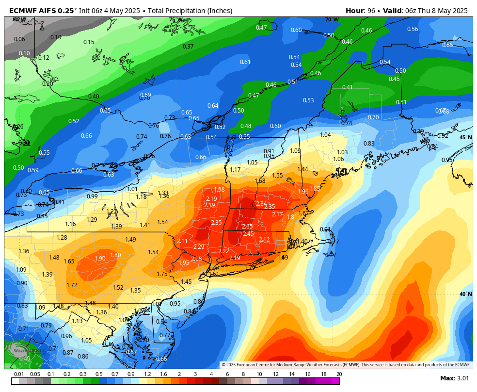
TABLE OF CONTENTS
* Daily Celestials (Sun/Moon Data)
* Sponsor Section
* Morning Discussion
~~~~~~~~~~~~~~~~~~~~~~
YOUR DAILY CELESTIALS
~~~~~~~~~~~~~~~~~~~~~~
STAR:
–OUR STAR ROSE AT: 5:41am this morning
–OUR STAR SETS AT: 7:53pm this evening
–TOTAL DAYLIGHT TIME: 14 hours and 12 minutes
MOON:
–OUR MOON RISES AT: 12:01pm this morning
–MOON RISE DIRECTION: East-Northeast
–OUR MOON SETS AT: 2:44am tomorrow morning
–MOON SET DIRECTION: West-Northwest
–MOON PHASE: Waxing Gibbous (49.7%)
~~~~~~~~~~~~~~~~~~~~~~
>>> A NOTE FROM OUR WEEKEND SPONSOR <<<
Dave Hayes The Weather Nut is Sponsored by Individual Community Members, Patrons, and Gerard, Ghazey & Bates, P.C.
GGBPC is a Northampton-based law firm and is the area’s premier estate and tax planning provider. The firm specializes in Estate Planning, Elder Law, and Tax Law, so be sure to contact GGBPC today to see how they can help you.
Simply click the following link to their secure website.
~~~~~~~~~~~~~~~~~~~~~~
YOUR MORNING DISCUSSION
~~~~~~~~~~~~~~~~~~~~~~
Good morning folks, thank you very much for all of your reports, pics, vids and accounts of what transpired yesterday which was truly a severe weather event in parts of Hampden County, southeast Hampshire County and southern Worcester County.
While the National Weather Service would have to come out and do an official survey of the damage and do a forensic analysis of radar, satellite and other observational data to make their conclusions, I believe that what transpired based on accounts I’ve read and video footage I saw out of Springfield, MA by Paul Taschereau Jr. (a gustnado or EF-0 tornado) and also out of Holyoke, MA by Brett Pitoniak (a clearly-rotating wall cloud) was a combination of a weaker tornado or a gustnado, followed by a microburst with severe thunderstorm straight line winds mixed in.
As you all know, I am not a meteorologist so I cannot make any conclusions based on my thoughts about secondhand footage and accounts, but I have a very hard time believing that what folks experienced yesterday was just straight line wind damage from a severe thunderstorm. I *saw* rotational footage, so something else obviously transpired.
If you have additional footage, please post below, thank you.
II heard that one person had to be hospitalized and I hope they are going to be ok, and hope nobody else got hurt, and am very sorry to see all of the property damage that took place. It was an awful day, to be sure and I hope nobody else got injured and that you are able to recover.
Going forward, we have a new setup where our still-cutoff upper low over Kentucky and the southern Ohio Valley will join together with high pressure positioning itself early this week over southeast Canada.
With counterclockwise flow around the upper low southwest of us, and clockwise flow around the high northeast of us, that will drive southerly and southeasterly moist ocean flow right into the greater WMass region starting tonight and lasting through Tuesday night, followed by the upper low tracking through New England on Wednesday.
While today will be a bit milder with highs well into the 60s after patchy fog burns off, with some low 70s, and only an isolated shower or thunderstorm, by tonight our incoming periods of rainfall arrives.
The next 48-60 hours will feature a very narrow temperature margin with highs in the upper 50s to mid 60s and lows in the upper 40s to mid 50s, so about a 10-degree fluctuation from night to noon.
In addition, this macro set up looks to (starting by later this afternoon or early evening) produce periods of showers, some heavy at times, potentially with an embedded non-severe thunderstorm, from overnight tonight through Monday, Monday night, Tuesday and Tuesday night!
This is a longer-duration, semi-firehose type of event feeding rainfall off of the ocean and into the greater WMass region. Anywhere from 1.5″ to over 3″ of rain is possible (see attached chart).
There will be lulls in the action here and there, but expect damp, rainy conditions over the next several days, and I can’t rule out river rises to the extent where minor flooding is possible, but I will update on that by early tomorrow.
By Wednesday, the upper low will finally reattach to the jet stream and track through New England, producing more instability showers on Wednesday and Wednesday night, with a potential by late week to see some drying with partial sunshine breaking out and warmer temps into the 60s and low 70s for highs.
There is a low chance for a coastal storm to bring more rain next weekend, but it’s just something to monitor for now.
Thankfully there is no more severe weather expected on the horizon, as our first severe thunderstorm event of the new 2025 warm season was certainly and factually brutal, and I hope folks are able to recover, and hang in there.
“Follow your bliss and the Universe will open doors for you where there were only walls.”
― Joseph Campbell