
Today’s Nutshell: Good morning folks, with a cold front pressing southeast this afternoon and evening combined with very warm, moist southwest flow ahead of it pushing into the greater WMass region, the table is set for instability, moisture, wind shear and highs near 80º to fuel the development of scattered strong to perhaps severe thunderstorms. 2-8pm or so. A couple of storms could become severe and produce isolated damaging wind gusts, small hail, frequent lightning or street flooding as our first severe weather potential looks more likely than not. Beyond tonight, more periods of rain through Wednesday look likely.
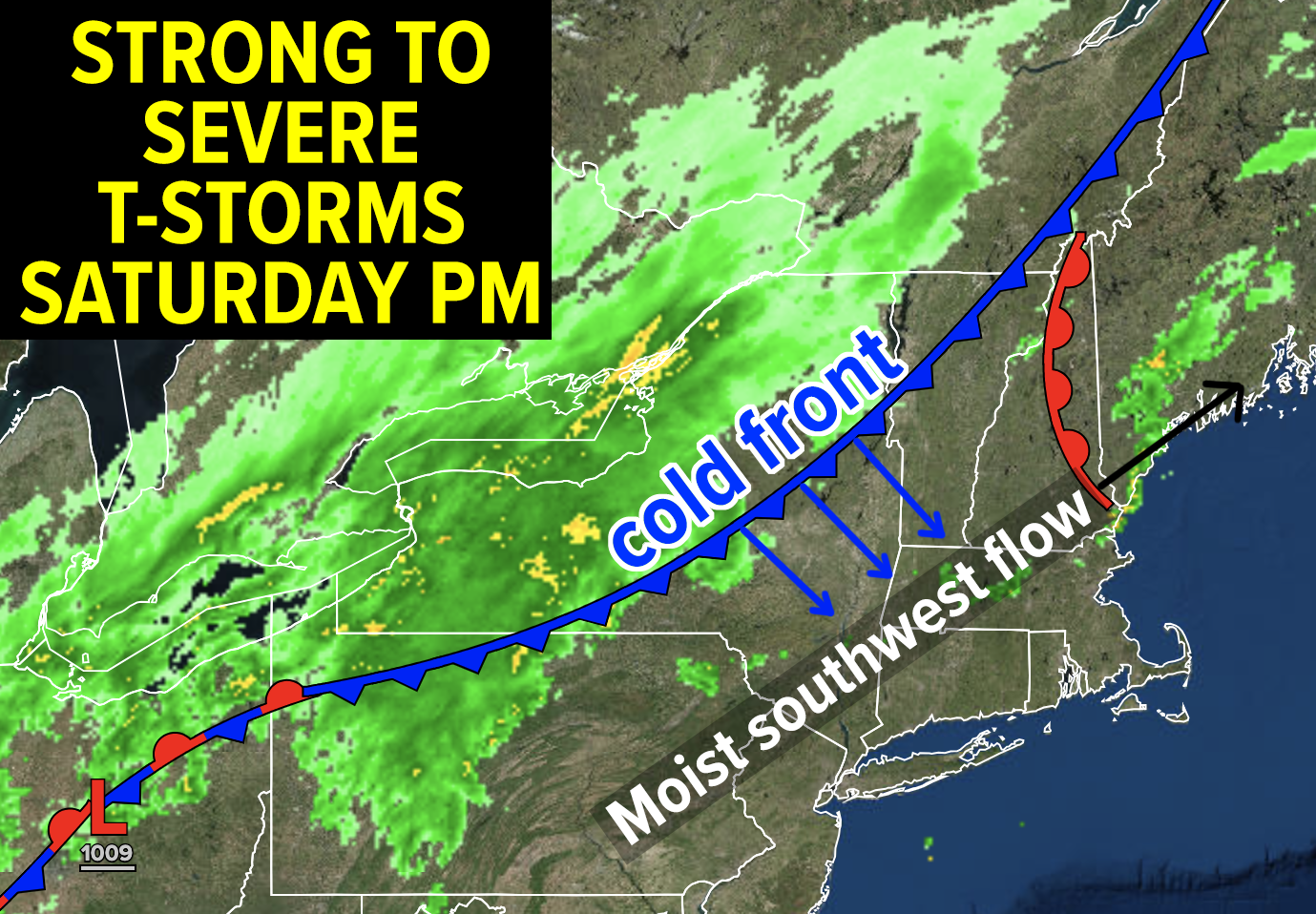
TABLE OF CONTENTS
* Daily Celestials (Sun/Moon Data)
* Sponsor Section
* Your Short-Term ZoneCast
* Morning Discussion
~~~~~~~~~~~~~~~~~~~~~~
YOUR DAILY CELESTIALS
~~~~~~~~~~~~~~~~~~~~~~
STAR:
–OUR STAR ROSE AT: 5:43am this morning
–OUR STAR SETS AT: 7:51pm this evening
–TOTAL DAYLIGHT TIME: 14 hours and 8 minutes
MOON:
–OUR MOON RISES AT: 10:50am this morning
–MOON RISE DIRECTION: Northeast
–OUR MOON SETS AT: 2:17am tomorrow morning
–MOON SET DIRECTION: Northwest
–MOON PHASE: Waxing Crescent (38.8%)
~~~~~~~~~~~~~~~~~~~~~~
>>> A NOTE FROM OUR WEEKEND SPONSOR <<<
Dave Hayes The Weather Nut is Sponsored by Individual Community Members, Patrons, and Gerard, Ghazey & Bates, P.C.
GGBPC is a Northampton-based law firm and is the area’s premier estate and tax planning provider. The firm specializes in Estate Planning, Elder Law, and Tax Law, so be sure to contact GGBPC today to see how they can help you.
~~~~~~~~~~~~~~~~~~~~~~
YOUR SHORT-TERM ZONECAST
~~~~~~~~~~~~~~~~~~~~~~
ZONE 1 – Northern Region
(Southern VT, Southwest NH)
–Highs Today: Low to Upper 70s
–Lows Tonight: Low to Mid 50s
–Highs Tomorrow: Upper 50s to Mid 60s
–Winds: Light wind through tomorrow except in any strong/severe t-storms
–Skies: Partly sunny early, then Mostly cloudy through tomorrow
–Precip: Scattered showers and t-storms this afternoon, with more showery periods, at times, late tonight into Sunday. Sunday may become a washout depending on atmospheric boundary placement in VT/NH
–NWS Alerts + Nut Notes: Severe thunderstorms possible 2-8pm!
ZONE 2 – Central Region
(Western MA, North-Central MA, Northern Litchfield CT)
–Highs Today: Mid 70s to Low 80s
–Lows Tonight: Mid to Upper 50s
–Highs Tomorrow: 60s to Low 70s
–Winds: Light wind through tomorrow except in any strong/severe t-storms
–Skies: Partly sunny early, then Mostly cloudy through tomorrow
–Precip: Scattered showers and t-storms this afternoon, with more showery periods, at times, late tonight into Sunday.
–NWS Alerts + Nut Notes: Severe thunderstorms possible 2-8pm!
ZONE 3 – Southern Region
(South-Central MA, Northern CT)
–Highs Today: Low 80s
–Lows Tonight: Near 60º
–Highs Tomorrow: Low 70s
–Winds: Light wind through tomorrow except in any strong/severe t-storms
–Skies: Partly sunny early, then Mostly cloudy through tomorrow
–Precip: Scattered showers and t-storms this afternoon especially in Litchfield and Hartford Counties, with more showery periods at times late tonight and again Sunday night.
–NWS Alerts + Nut Notes: Severe thunderstorms possible 2-8pm, especially in northwest CT
~~~~~~~~~~~~~~~~~~~~~~
YOUR MORNING DISCUSSION
~~~~~~~~~~~~~~~~~~~~~~
Good morning folks, as we move into May and witness nature’s full-leaf-out resplendency display, it seems fitting that our first severe weather potential is arriving on our shores this afternoon and evening with temps cresting 80º, dewpoints cresting into the mid 60s, and capped off by my life-taking thump of this season’s first mosquito just minutes ago.
Today is a real taste of Summah (which starts next month!) and some of us may get the storms to prove it.
We’re starting off partly sunny with just a few tiny showers around. As the morning wears on into early afternoon, a cold front will be tracking southeast towards the greater WMass region while southwest flow with increasing humid air works into the region.
I think we’re mostly in the clear through about 2pm, but after that, stronger instability will be developing in the region along with stronger wind shear with strong low level lapse rates.
When instability meets changes in wind speed and direction with height (wind shear) and stronger lapse rates (temps that cool faster as you go up in elevation), all you need is a trigger to start the air rising, and that will be our cold front acting to scoop the air skyward. Buoyancy takes over after that initial lift and storms can bubble up into those puffy, cottony cumulonimbus clouds.
Showers and storms likely first form over SVT and SWNH, but by mid to late afternoon WMass should see areas of stronger thunderstorms, and some may become severe with isolated wind gusts of 50-60mph that may cause some tree or line damage in sporadic spots. Hail and torrential rain is also possible, as highs crest well into the 70s to low 80s, cooling tonight.
Keep an eye and an ear trained to west today!
For tonight, lows will dip into the 50s and we’ll see periods of rainfall with perhaps a rumble of thunder overnight, along with patchy fog.
For Sunday, the best chance for rain showers is well north of the Route 2 corridor in far northern MA but more so in southern and central VT and NH.
But with time and as another wave ejects east off of the stalled upper low to our west, we’ll see rainfall filling in through the entire greater WMass region (SVT, SWNH, WMass, CMass and NCT) into the evening and overnight period.
Highs will only reach the upper 50s to mid 60s with lows in the upper 40s to mid 50s.
Monday, Tuesday and Wednesday are all going to feature more seasonable temps in the upper 50s and 60s for highs with 40s and 50s for low with periods of rainfall as our upper low currently stuck in an omega-blocking pattern is released from its bondage, and allowed to join back up with the northern jet stream and track right through New England by Wednesday and Thursday.
Again, I will refine shower/rain timing impacts we get closer to that early to mid week period, but these upper lows are notorious uncertainty providers when it comes to forecasting.
Here’s hoping that by late week the shower potential will be dwindling and that we’ll start getting some more sunshine to work back into the region.
Have a great day, and if you have outdoor stuff, keep an eye/ear west and have a plan to out of the elements should they coalesce into a temporary tempest!
“Follow your bliss and the Universe will open doors for you where there were only walls.”
― Joseph Campbell