
Today’s Nutshell: We’ve seen a third to two-thirds of an inch of rainfall overnight and more is on the way this morning followed by scattered showers, downpours and possibly a couple of thunderstorms, winding down by tonight. Sunday is blustery and cooler with a big Fall feel, followed by more sun and warming temps through mid-week when a few showers may revisit our region.
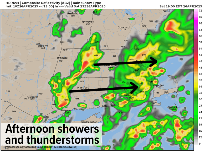
TABLE OF CONTENTS
* Daily Celestials (Sun/Moon Data)
* Sponsor Section
* Your Short-Term ZoneCast
* Morning Discussion
~~~~~~~~~~~~~~~~~~~~~~
YOUR DAILY CELESTIALS
~~~~~~~~~~~~~~~~~~~~~~
STAR:
–OUR STAR ROSE AT: 5:52am this morning
–OUR STAR SETS AT: 7:44pm this evening
–TOTAL DAYLIGHT TIME: 13 hours and 52 minutes
MOON:
–OUR MOON SETS AT: 6:39pm this afternoon
–MOON SET DIRECTION: West-Northwest
–OUR MOON RISES AT: 5:26am tomorrow morning
–MOON RISE DIRECTION: East-Northeast
–MOON PHASE: Waning Crescent (2.6%)
~~~~~~~~~~~~~~~~~~~~~~
>>> A NOTE FROM OUR WEEKEND SPONSOR <<<
Dave Hayes The Weather Nut is Sponsored by Individual Community Members, Patrons, and Gerard, Ghazey & Bates, P.C.
GGBPC is a Northampton-based law firm and is the area’s premier estate and tax planning provider. The firm specializes in Estate Planning, Elder Law, and Tax Law, so be sure to contact GGBPC today to see how they can help you.
Simply click the following link to their secure website.
~~~~~~~~~~~~~~~~~~~~~~
YOUR SHORT-TERM ZONECAST
~~~~~~~~~~~~~~~~~~~~~~
ZONE 1 – Northern Region
(Southern VT, Southwest NH)
–Highs Today: Low to Mid 60s (upper 60s near Bennington VT)
–Lows Tonight: Mid 30s to Low 40s
–Highs Tomorrow: Mid 40s to Low 50s
–Winds: Light southerly today, westerly with gusts to 25mph tonight, then northwest winds gust 25-40mph Sunday
–Skies: Cloudy today and tonight, mostly cloudy tomorrow
–Precip: Periods of showers through the day, thunder possible, tapering off tonight
–NWS Alerts + Nut Notes: No alerts but watch for street flooding in isolated areas under any heavier showers this afternoon, given antecedent rainfall
ZONE 2 – Central Region
(Western MA, North-Central MA, Northern Litchfield CT)
–Highs Today: 60s to near 70º
–Lows Tonight: Upper 30s to Mid 40s
–Highs Tomorrow: Upper 40s to Mid 50s
–Winds: Light southerly today, westerly with gusts to 25mph tonight, then northwest winds gust 25-45mph Sunday
–Skies: Cloudy today and tonight, mostly cloudy tomorrow w/ a few sunny breaks
–Precip: Periods of showers through the day, thunder possible, tapering off tonight
–NWS Alerts + Nut Notes: No alerts but watch for street flooding in isolated areas under any heavier showers this afternoon, given antecedent rainfall
ZONE 3 – Southern Region
(South-Central MA, Northern CT)
–Highs Today: 60s to near 70º
–Lows Tonight: Low to Mid 40s
–Highs Tomorrow: Mid 50s
–Winds: Light southerly today, westerly with gusts to 25mph tonight, then northwest winds gust 25-45mph Sunday
–Skies: Cloudy today and tonight, partly sunny tomorrow, especially by afternoon
–Precip: Periods of showers through the day, thunder possible, tapering off tonight
–NWS Alerts + Nut Notes: No alerts but watch for street flooding in isolated areas under any heavier showers this afternoon, given antecedent rainfall
~~~~~~~~~~~~~~~~~~~~~~
YOUR MORNING DISCUSSION
~~~~~~~~~~~~~~~~~~~~~~
Good morning everybody, I’m sure many of us heard that pitter-pattery thrum of heavier rainfall on our roofs in the middle of the night, I know I sure did! I love that sound, it reminds me that I live within an incomprehensively massive nature system that I am at the mercy of, and while that makes most folks feel small it makes me feel connected.
Some of us received close to three-quarters of an inch of rainfall overnight, while others got less, but more rain is on the way today, and some folks will likely end up with over an inch through midnight tonight.
The first wave of heavier rain is into CMass and exiting northeast, but more batches of rain are pushing through the Berkshires and the rest of the region this morning.
We’ll see some lulls and maybe even some sunny breaks later, but it looks like a mostly cloudy day for sure with highs in the 60s.
By mid to late afternoon, we may see some thunderstorms or downpours develop as a cold front starts to press east towards our region, and while severe weather isn’t expected we could see some isolated street flooding develop given the rain we already received earlier.
For tonight, showers should taper off before midnight and west winds should pick up behind the front with gusts up to 25mph or so into the early morning, with lows in the mid 30s to mid 40s from north to south.
A few folks in SVT or far northwest MA may even see some snowflakes mix in as upper-trough-related showers develop early Sunday.
Today is a very different day than yesterday, and tomorrow will be a very different day than today, with northwest winds developing and colder air advecting into the region for Sunday, producing highs only in the mid 40s to mid 50s from north to south, mostly cloudy skies, and a few instability showers.
North-central and northeast CT into southern MA areas east of I-91 are more likely to enjoy partly sunny skies.
Northwest wind gusts should reach 25-45mph at times, which will produce wind chills down into the 40s and possibly upper 30s for some! It’ll be a brisk day so dress accordingly. Lows will drop into the upper 30s to mid 40s as the trough clears east of us, and we dry out at all levels.
High pressure builds into the region for Monday through Wednesday, which look lovely, sunny, and increasingly warm with highs in the 60s Monday, and then the 70s Tuesday and Wednesday. A weakening frontal boundary will push through Tuesday night into early Wednesday with a few showers, but it doesn’t look like much.
By late week we’ll drop our temps back down into the 60s behind that front, and by next weekend we may be looking at more shower activity, but I’ll parse that out for you as we get closer.
I hope you have a great day, and that some grand epiphany drops on you today!
“Follow your bliss and the Universe will open doors for you where there were only walls.”
― Joseph Campbell