
TABLE OF CONTENTS
* Daily Celestials (Sun/Moon Data)
* Sponsor Section
* Morning Discussion
* TIP: Scroll to your section, or read more
~~~~~~~~~~~~~~~~~~~~~~
YOUR DAILY CELESTIALS
~~~~~~~~~~~~~~~~~~~~~~
STAR:
–OUR STAR ROSE AT: 6:12am this morning
–OUR STAR SETS AT: 7:29pm this evening
–TOTAL DAYLIGHT TIME: 13 hours and 17 minutes
MOON:
–OUR MOON SET AT: 6:13am this morning
–MOON SET DIRECTION: West-Southwest
–OUR MOON RISES AT: 8:29pm this evening
–MOON RISE DIRECTION: East-Southeast
–MOON PHASE: Waning Gibbous (99.8%)
~~~~~~~~~~~~~~~~~~~~~~
>>> A NOTE FROM OUR WEEKEND SPONSOR <<<
Dave Hayes The Weather Nut is Sponsored by Individual Community Members, Patrons, and Gerard, Ghazey & Bates, P.C.
GGBPC is a Northampton-based law firm and is the area’s premier estate and tax planning provider. The firm specializes in Estate Planning, Elder Law, and Tax Law, so be sure to contact GGBPC today to see how they can help you.
Simply click the following link to their secure website.
~~~~~~~~~~~~~~~~~~~~~~
YOUR MORNING DISCUSSION
~~~~~~~~~~~~~~~~~~~~~~
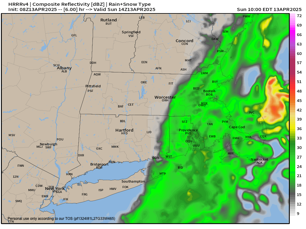
Good morning folks, we’ve got a giant upper trough sitting over our heads this morning which is drawing precipitation from a surface low westward into eastern MA and RI, and will probably pull a few showers into eastern CT and eastern CMass, but the precipitation’s westward progress should be thwarted by that system eventually pulling east and out to sea.
Meanwhile, our wind will shift (roughly) from east to west and start drying out the cloud deck. Given this, some sunny periods are expected in the afternoon with highs reaching the 45-50º range. Patchy drizzle will also be possible, and aside from isolated areas of SVT and SWNH, temps are already above freezing so the freezing drizzle threat is waning rapidly.
For tonight, clouds continue to break up with lows dipping into the low to mid 30s as upper ridging starts to nose into the region.
Monday is looking gorgeous with mostly sunny skies and highs in the upper 50s to mid 60s, with clouds increasing late.
A disturbance will move through our flow and produce some scattered showers Monday night into Tuesday with lows in the low to mid 40s.
Showers end Tuesday, and then we await the passage of a cold front with highs reaching the mid 50s to low 60s.
For Tuesday night, the front swings through and brings scattered showers. With lows in the upper 20s to mid 30s, some of these could become snow showers. There is a signal that some lake effect snow showers may be developing behind the front into the Berkshires / SW.VT / NW.CT for very early Wednesday morning, preceding an increase in westerly wind gusts for Wednesday.
Gust should reach speeds of at least 20-35mph and may hit 40mph in spots. Highs on Wednesday will be cooler compared to early in the week, reaching the 40s under partly sunny to mostly cloudy skies from east to west across the greater WMass region. Lows bottom out in the upper 20s to mid 30s.
By late week, return southerly flow starts to develop behind a departing upper trough, with sunshine and highs in the mid 40s to mid 50s Thursday.
More sun is expected on Friday with milder highs reaching the mid 50s to low 60s.
As of now, it looks like another wet Saturday may be in store for us, but I will keep you updated on that, as a lot can change between now and then!
Have a great rest of your weekend!
“Follow your bliss and the Universe will open doors for you where there were only walls.”
― Joseph Campbell