
TABLE OF CONTENTS
* Daily Celestials (Sun/Moon Data)
* Sponsor Note
* Morning Discussion
* TIP: Scroll below for sections, or read all
~~~~~~~~~~~~~~~
YOUR DAILY CELESTIALS
~~~~~~~~~~~~~~~~~~~~~~
STAR:
–OUR STAR ROSE AT: 6:17am this morning
–OUR STAR SETS AT: 7:26pm this evening
–TOTAL DAYLIGHT TIME: 13 hours and 9 minutes
MOON:
–OUR MOON RISES AT: 5:23pm this afternoon
–MOON RISE DIRECTION: East
–OUR MOON SETS AT: 5:36am tomorrow morning
–MOON SET DIRECTION: West
–MOON PHASE: Waxing Gibbous (94.3%)
~~~~~~~~~~~~~~~~~~~~~~
A NOTE FROM OUR SPONSOR
~~~~~~~~~~~~~~~~~~~~~~
Dave Hayes The Weather Nut is Sponsored by Individual Community Members, Patrons, and Tandem Bagel Company… No matter the weather, Tandem Bagel is always there for you at several valley locations to make your mornings brighter! With *New Pizza Bagels(!)*, along with bagels baked fresh daily (including Gluten-Free options), house-whipped cream cheese, coffee, and tons of lunch options, Tandem is the perfect quick stop for lunch, breakfast, or a coffee and bagel to go.
You can either 1) visit them in Easthampton, Northampton, Hadley, Florence, and/or West Springfield, 2) hire them to cater your next event, or 3) use their super-streamlined online ordering tool by visiting their website and clicking the “Catering” or “Order Online” links.
~~~~~~~~~~~~~~~~~~~~~~
YOUR MORNING DISCUSSION
~~~~~~~~~~~~~~~~~~~~~~
Good morning folks, be sure to enjoy the sunshine for the first part of your Thursday, as our super bright yellow-white sky orb around which we swing year to year, that very same one with which we (and the rest of the heliosphere) collectively burrow a path through the cosmic substrate, will be mostly going behind the clouds through at least Saturday, and part of Sunday, too.
So soak up some rays, peeps, because more atmospheric inclemency is imminent.
For today, highs will reach well into the 40s and low 50s with a light south wind and partly to mostly sunny skies giving away to mostly cloudy skies by evening.
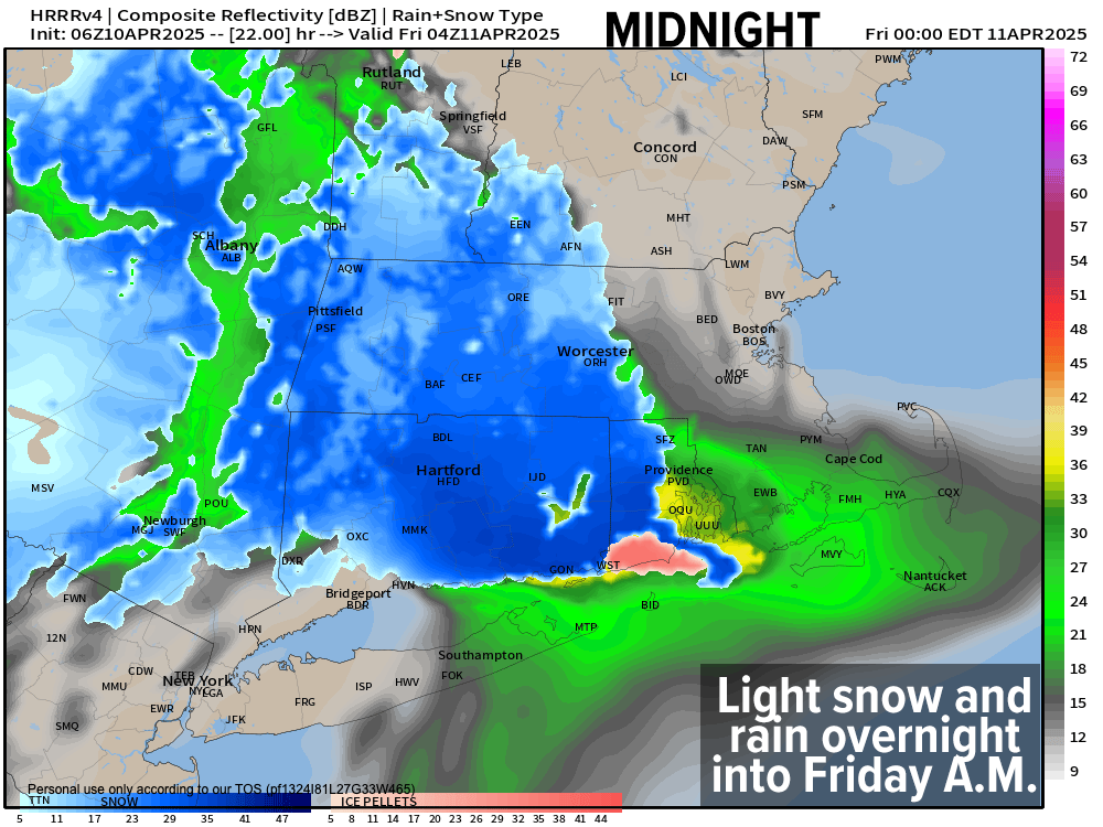
We have a weak disturbance lifting northeast toward New England that will push precipitation into the greater WMass region between about 6-10pm tonight.
It likely takes the form of valley rain and high terrain mix to start, but should transition to light snow/sleet mix along and north of the Pike, and possibly south of there as well, but it’ll be a light system. Rain will probably persist longer in the valley floor from Hartford/Springfield north to Northampton until any mix or snow develops later this evening.
Despite the light precip, high terrain areas like the eastern Berkshires, western hilltowns, SVT/SWNH and northern CMass into eastern Franklin County could see a coating to an inch or so of wet snow and sleet by Friday morning, with everything winding down by mid morning. Lows will dip to the mid-morning.
For Friday, with easterly flow in place off the ocean, clouds will likely persist with highs in the 40s with mostly dry conditions.
Then by Friday early evening, low pressure to our south will bob north off of the Mid-Atlantic coastline along the eastern flank of an upper trough near the Appalachian Mountains. This will push rain back into our region for early Friday night into Saturday.
This more southerly flow likely keeps valley areas all rain, but with dynamic cooling present during heavier/steadier precipitation Friday night into Saturday, some additional wet snow accumulations with sleet of a coating to 3” are possible, especially above 1500-2000 feet in elevation.
Lows Friday night drop into the low to mid 30s with highs Saturday in the mid 30s to mid 40s from north to south. Precipitation lasts into Saturday and tapers to scattered activity later in the afternoon and evening with lows in the low to mid 30s.
For Sunday many of us should start off dry with mostly cloudy skies in the 45-50º range, but another coastal storm likely passes far southeast of New England, grazing northeast CT and parts of CMass (eastern half) with more rain showers by afternoon, which may continue into the evening before that storm pulls out to sea. Lows will dip into the 30s.
Behind that system, warm air builds into the region for Monday and Tuesday with highs in the mid 50s to mid 60s under sunnier skies, so that will be a nice reward for the dreary dampness we’re about to endure.
However, by Tuesday night another cold front will work in from the west and spread rainfall into our region by Tuesday night as a strong low center pushes east through the St. Lawrence River Valley in southern Canada.
This will drag colder air back into the region by Wednesday, and strong northwest winds may develop with a potential for lake effect snow showers in the Berkshires and SVT.
Have a great day!
“Follow your bliss and the universe will open doors for you where there were only walls.”
― Joseph Campbell