
TABLE OF CONTENTS
* Daily Celestials (Sun/Moon Data)
* Sponsor Section
* Morning Discussion
* TIP: Scroll to your section, or read more
~~~~~~~~~~~~~~~~~~~~~~
YOUR DAILY CELESTIALS
~~~~~~~~~~~~~~~~~~~~~~
STAR:
–OUR STAR ROSE AT: 6:24am this morning
–OUR STAR SETS AT: 7:21pm this evening
–TOTAL DAYLIGHT TIME: 12 hours and 57 minutes
MOON:
–OUR MOON RISES AT: 1:02pm this afternoon
–MOON RISE DIRECTION: East-Northeast
–OUR MOON SETS AT: 4:15am tomorrow morning
–MOON SET DIRECTION: West-Northwest
–MOON PHASE: Waxing Gibbous (64.7%)
~~~~~~~~~~~~~~~~~~~~~~
>>> A NOTE FROM OUR WEEKEND SPONSOR <<<
Dave Hayes The Weather Nut is Sponsored by Individual Community Members, Patrons, and Gerard, Ghazey & Bates, P.C.
GGBPC is a Northampton-based law firm and is the area’s premier estate and tax planning provider. The firm specializes in Estate Planning, Elder Law, and Tax Law, so be sure to contact GGBPC today to see how they can help you.
Simply click the following link to their secure website.
~~~~~~~~~~~~~~~~~~~~~~
YOUR MORNING DISCUSSION
~~~~~~~~~~~~~~~~~~~~~~
Good morning folks, we’ve entered an active pattern and there’s no signs of that slowing down through next weekend, so since I’m in a double—dash kind of mood this morning, I’m gonna bust a move on a bunch of ‘em and dispense an itemized plethora of points for our collective review below:
–We’ve got a period of morning showers moving through the region as a wave sweeps on by
–Behind that, we should mostly dry out this afternoon with an isolated shower possible, along with some sunny breaks
–Highs will reach the mid 40s to mid 50s from north to south
–Clouds increase tonight with a cold front moving through that will drop our temps into the upper 20s to mid 30s from north to south
–As this happens, low pressure will form along a stalled boundary south of the New England coast
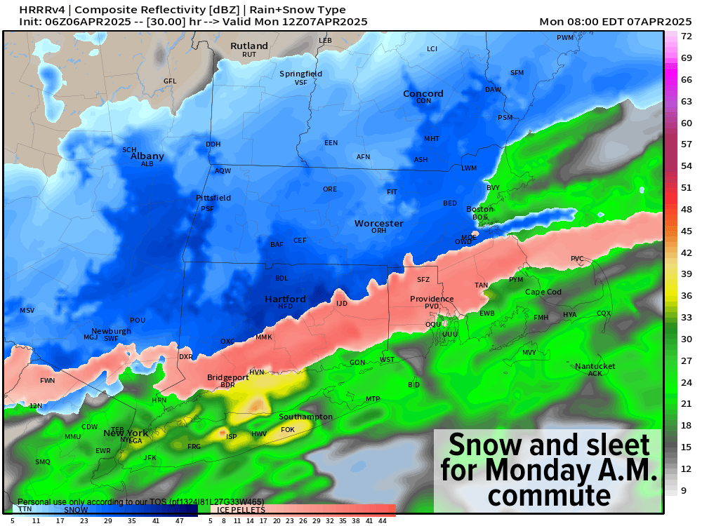
–This low likely tracks a bit further south than expected, which helps lock in colder air to support a change from rain to sleet/snow but also pulls heaviest precip south of our region
–Still, after midnight rain and snow should quickly turn to sleet and snow, and then possibly all snow by dawn on Monday morning, but light to moderate in intensity
–By dawn, most of us should be seeing light snow, even into Litchfield County CT and the northern halves of northern CT, with some rain mixed in down there
–A coating to 2” of snow/sleet is expected with 1-2” in the high terrain, MAYBE up to 3” if the storm comes a little further north, and valley coatings
–Snow and rain showers could last past noon on Monday, changing to scattered valley rain showers and high terrain snow or mixed rain/snow/sleet.
–Highs will reach the mid 30s to mid 40s under mostly cloudy skies
–A cold front will sweep into the region Monday night into the pre-dawn hours of Tuesday with more snow showers possible and lows in the mid 20s to low 30s
–On Tuesday, behind the front, a blustery partly sunny day is expected with strong west-northwest wind gusts of 25-40mph (maybe higher)
–High temps will only reach the mid 30s to low 40s and with those kinds of winds, wind CHILL will truly be chilly down into the 20s during the day!
–Tuesday night features legit winter cold with lows in the upper teens to mid 20s, followed by a mostly sunny Wednesday with highs in the upper 30s to mid 40s with less wind (lows will dip into the 20s for another cold night)
–We should then moderate into late week and the weekend, with highs more in the upper 40s to mid 50s range
–However, both on Thursday night into Friday, and again on Saturday, MORE rainfall is possible
I think it’s safe to say that by the end of next weekend, regardless of what the normally-conservative Drought Monitor says, we’ll have recovered from the 2024 drought for the most part
Thanks for reading and I hope you have a great day, and I will update again by late this afternoon and early evening re: our wintry precip potential for late tonight and tomorrow morning.
“Follow your bliss and the Universe will open doors for you where there were only walls.”
― Joseph Campbell