
TABLE OF CONTENTS
* Daily Celestials (Sun/Moon Data)
* Sponsor Section
* Morning Discussion
* TIP: Scroll to your section, or read more
~~~~~~~~~~~~~~~~~~~~~~
YOUR DAILY CELESTIALS
~~~~~~~~~~~~~~~~~~~~~~
STAR:
–OUR STAR ROSE AT: 6:25am this morning
–OUR STAR SETS AT: 7:20pm this evening
–TOTAL DAYLIGHT TIME: 12 hours and 55 minutes
MOON:
–OUR MOON RISES AT: 11:52am this morning
–MOON RISE DIRECTION: Northeast
–OUR MOON SETS AT: 3:45am tomorrow morning
–MOON SET DIRECTION: Northwest
–MOON PHASE: Waxing Gibbous (54.7%)
~~~~~~~~~~~~~~~~~~~~~~
>>> A NOTE FROM OUR WEEKEND SPONSOR <<<
Dave Hayes The Weather Nut is Sponsored by Individual Community Members, Patrons, and Gerard, Ghazey & Bates, P.C.
GGBPC is a Northampton-based law firm and is the area’s premier estate and tax planning provider. The firm specializes in Estate Planning, Elder Law, and Tax Law, so be sure to contact GGBPC today to see how they can help you.
Simply click this link to their secure website.
~~~~~~~~~~~~~~~~~~~~~~
YOUR MORNING DISCUSSION
~~~~~~~~~~~~~~~~~~~~~~
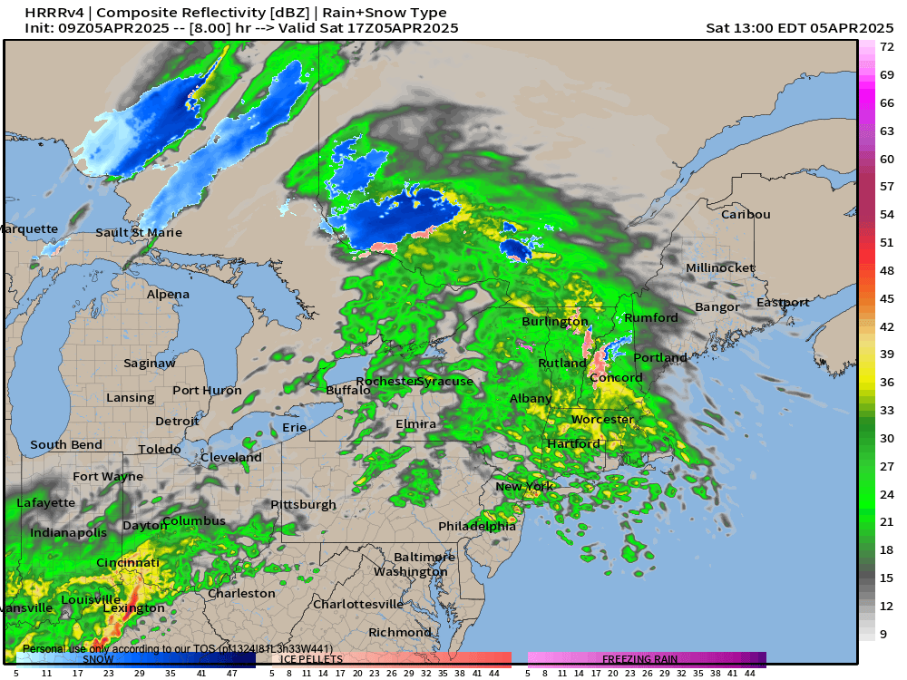
Good morning folks, a raw, damp, rainy day lies ahead as a warm frontal boundary extending towards New England from a storm in the northern Ohio Valley that will track northeast into the eastern Great Lakes region today and tonight.
Meanwhile cold high pressure over eastern Maine will slowly be pushed east into Atlantic Canada, but not before establishing a cold drain at the surface southwestward into the greater WMass region to keep our highs firmly in the 40s, with some folks even falling into the mid to upper 30s later today and this evening.
A few showers are around, but by late morning, the steadier / heavier rainfall moves in for the day and lasts until about early evening.
After that, some patchy dense fog, isolated showers, and mist is drizzle is possible, along with a chance that as the warm front actually pushes into the south coast and southern CT, some downpours or a few thunderstorms may move through northern CT, maybe up to the level of the Pike in far southern MA. Lows will drop into the mid 30s to low 40s.
For Sunday, occasional showers will be possible, but I expect less activity than today, along with milder highs in the mid 40s to mid 50s.
However, a cold front will be dropping south through our region. At the same time, an upper low will push closer to the northeast U.S. and help generate a secondary low pressure center that will track east along the cold front passing to our south by Sunday evening.
As this happens, rain will likely redevelop from west to east into the Berkshires, southwest VT and northwest CT starting between about 10pm and midnight, taking advantage of the coldest time of day (i.e. the night) while cold air drains southward.
This will help to likely turn areas north of the Pike, and especially at elevation, from rain to snow and/or sleet, and this could last into the Monday morning commute.
I wouldn’t be surprised to see some Winter Weather Advisories hoisted by tonight or tomorrow morning, assuming this trend continues.
Lows Sunday night will dip into the upper 20s to mid 30s from north to south, and we could see a coating to 3” in parts of the area, especially the high terrain, with some grassy accumulation even in the CT River Valley floor, so I will keep you updated on this late-season, minor winter weather potential.
Monday mixed precip of snow, sleet and rain should wind down to scattered rain and snow showers, with highs in the upper 30s to mid 40s, with a few snow showers possible at night with lows in the mid 20s to low 30s.
On Tuesday, a strong cold front sweeps through and produces a colder, blustery day with northwest winds gusts of 25-40mph possibly, and highs only in the 30s with wind chills in the 20s, and lows either side of 20º!!
A chilly, fair weather day Wednesday with highs in the mid 30s to mid 40s and lows in the 20s to low 30s gives way to a release from the cold, and milder temps well into the 50s for late week with more showers possible by Friday or Saturday.
Have a great day and don your rain gear, peeps!
“Follow your bliss and the Universe will open doors for you where there were only walls.”
― Joseph Campbell