
–> 100s of storms over 12 years
–> 1000s of reports & updates
–> Help Dave keep showing up through all of it
–> 65% towards the 4% reader goal, Drive ends 3/16
–> Please support Dave’s work todaY
–> SecureClick
~~~~~~~~~~~~~~~
TABLE OF CONTENTS
* Daily Celestials (Sun/Moon Data)
* Sponsor Note
* Morning Discussion
* TIP: Scroll below for sections, or read all
~~~~~~~~~~~~~~~
YOUR DAILY CELESTIALS
~~~~~~~~~~~~~~~~~~~~~~
STAR:
–OUR STAR ROSE AT: 6:18am this morning
–OUR STAR SETS AT: 5:45pm this evening
–TOTAL DAYLIGHT TIME: 11 hours and 27 minutes
MOON:
–OUR MOON RISES AT: 9:08am this morning
–MOON RISE DIRECTION: Northeast
–OUR MOON SETS AT: 1:13am tomorrow morning
–MOON SET DIRECTION: Northwest
–MOON PHASE: Waxing Crescent (36.8%)
~~~~~~~~~~~~~~~~~~~~~~
A NOTE FROM OUR SPONSOR
~~~~~~~~~~~~~~~~~~~~~~
Dave Hayes The Weather Nut is Sponsored by Individual Community Members, Patrons, and Tandem Bagel Company… No matter the weather, Tandem Bagel is always there for you at several valley locations to make your mornings brighter! With *New Pizza Bagels(!)*, along with bagels baked fresh daily (including Gluten-Free options), house-whipped cream cheese, coffee, and tons of lunch options, Tandem is the perfect quick stop for lunch, breakfast, or a coffee and bagel to go.
You can either 1) visit them in Easthampton, Northampton, Hadley, Florence, and/or West Springfield, 2) hire them to cater your next event, or 3) use their super-streamlined online ordering tool by visiting their website and clicking the “Catering” or “Order Online” links.
~~~~~~~~~~~~~~~~~~~~~~
YOUR MORNING DISCUSSION
~~~~~~~~~~~~~~~~~~~~~~
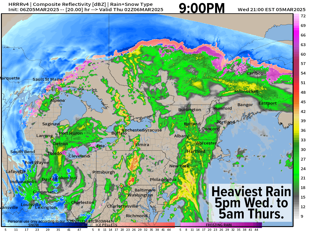
Good morning folks, we have a few showers moving through this morning with mostly mild temps except some valley areas and lower-elevation hilltowns that dipped into the upper 20s to low 30s due to wind dying down overnight unexpectedly. This may cause some black ice and/or brief icing early this morning as some light showers move through.
This activity should be brief, and despite a few isolated showers here and there, we should see a mostly dry day with mild highs rising into the mid 40s to mid 50s.
Southerly winds will pick up this afternoon and especially in the evening as a low level jet approaches and the pressure gradient tightens with the parent low WAY west of us, tracking towards the eastern Great Lakes overnight.
That puts us on the warm side of the storm, and those mild temps combined with the increasing pressure gradient and low level jet streak will help mix down gusts of 30-45mph late today and overnight, with highest gusts in northeast CT and southern CMass where I can’t rule out a 50mph wind gusts.
Rain will move back in by late afternoon and this evening, and it will fall heavily at times. With snow melt and heavy rain, there is a very low chance a stream or two may see some minor flooding, but it’s more likely we’ll see some street flooding / ponding later tonight into Thursday morning.
Lows tonight will hang in the mid to upper 40s as rain ends mostly by dawn.
There will be isolated showers at times on Thursday, and a couple may be heavy briefly, but it’ll likely be drier than it is actively raining on Thursday as highs rise into the upper 40s to mid 50s prior to a cold front passing through from west to east.
Behind that front, northwest winds will pick up and gust 30-45mph Thursday evening, and we could see some upslope snow showers set up in the Berkshires, SVT, northwest CT, and western hilltowns, and can’t rule out some fresh coatings by Friday morning as lows drop into the 20s.
We’ll have a second/final surge of wind Friday morning into first part of the day with gusts again in the 30-45mph range, although there’s a chance they could be higher than that.
Skies will be mostly sunny, and it will colder with highs in the mid 30s to low 40s with lows in the 20s as winds die down.
The weekend looks partly to mostly sunny with highs in the 30s and lows near 20º, but we may see a weak Clipper system by Sunday night into Monday that could bring some light snow, but no big whoop.
Fair weather and increasing temperatures develop by early next week, and by mid week someone may be approaching 60º, so the Spring seesaw continues!
Have a great day!
“Follow your bliss and the universe will open doors for you where there were only walls.”
― Joseph Campbell