
TABLE OF CONTENTS
* Daily Celestials (Sun/Moon Data)
* Sponsor Note
* Morning Discussion
* TIP: Scroll below for sections, or read all
~~~~~~~~~~~~~~~~~~~~~~
YOUR DAILY CELESTIALS
~~~~~~~~~~~~~~~~~~~~~~
STAR:
–OUR STAR ROSE AT: 6:31am this morning
–OUR STAR SETS AT: 5:35pm this evening
–TOTAL DAYLIGHT TIME: 11 hours and 4 minutes
MOON:
–OUR MOON SETS AT: 2:46pm this afternoon
–MOON SET DIRECTION: West-Southwest
–OUR MOON RISES AT: 5:59am tomorrow morning
–MOON RISE DIRECTION: East-Southeast
–MOON PHASE: Waning Crescent (8.4%)
~~~~~~~~~~~~~~~~~~~~~~
A NOTE FROM OUR SPONSOR
~~~~~~~~~~~~~~~~~~~~~~
Dave Hayes The Weather Nut is Sponsored by Individual Community Members, Patrons, and Tandem Bagel Company… No matter the weather, Tandem Bagel is always there for you at several valley locations to make your mornings brighter! With *New Pizza Bagels(!)*, along with bagels baked fresh daily (including Gluten-Free options), house-whipped cream cheese, coffee, and tons of lunch options, Tandem is the perfect quick stop for lunch, breakfast, or a coffee and bagel to go.
You can either 1) visit them in Easthampton, Northampton, Hadley, Florence, and/or West Springfield, 2) hire them to cater your next event, or 3) use their super-streamlined online ordering tool by visiting their website and clicking the “Catering” or “Order Online” links.
~~~~~~~~~~~~~~~~~~~~~~
YOUR MORNING DISCUSSION
~~~~~~~~~~~~~~~~~~~~~~
Good morning folks, The Human Circus continues to corkscrew through the Cosmos, and now is as good a time as any to remember to gently and slowly raise those eyebrows 10x this morning like an exercise and on the tenth time hold and put on a slight, almost-dumb smile, and hold for 10 seconds as you think of a good moment you had in your life, recent or otherwise.
After that, go about your day, but it’s a good exercise for your brain chemistry and can be helpful with whatever daily challenges are foisted upon you (notice I didn’t say hoisted… there is no meteorological hoisting happening anytime soon, as our local meteorology is more “meh” than anything).
The mild temps (mostly in the 30s) this morning is easy on the skeletal structures, so we’ve got that going for us.
In fact, with southerly flow, high temps are going to float on up into the 45-50º range as clouds increase in response to an incoming weak disturbance. Said disturbance will track north of us, keeping us on its warm side (i.e. southerly).
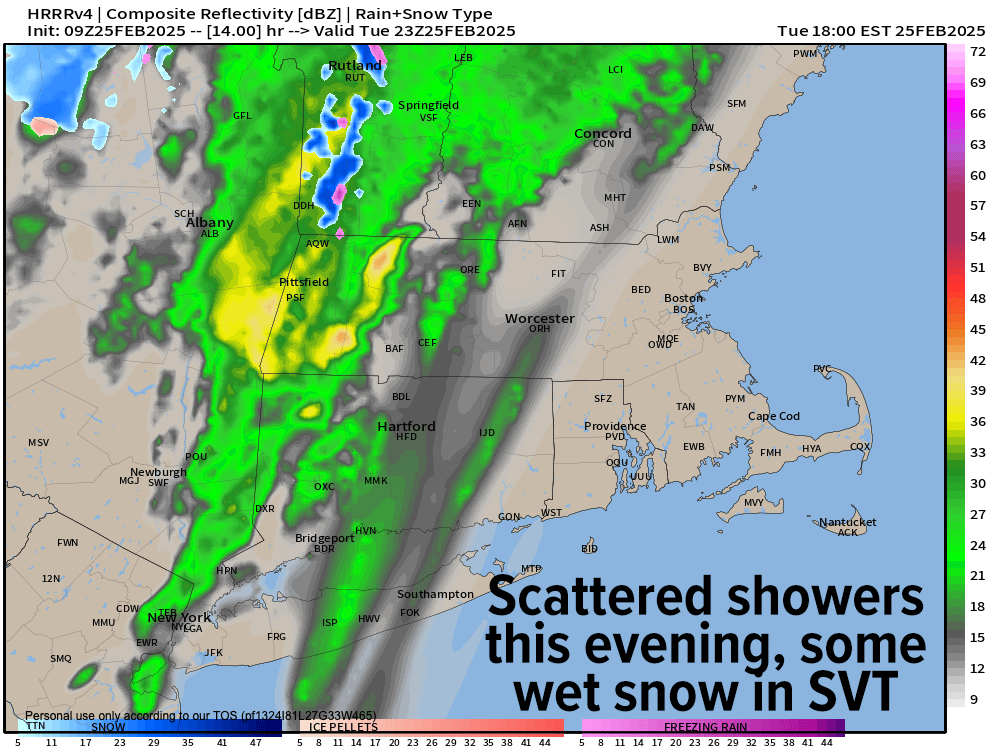
Clouds will be increasing today as this system passes into northern New England, but we’ll still see some scattered showers from it, starting late in the day into early evening, mostly north of the MA/CT state line.
I can’t rule out some fresh snow coatings in the spine of the southern Green Mountains with some snow/rain mix into northwest MA and high-terrain coatings there, too. Otherwise, it’s rain showers and lows will dip to either side of the freezing mark.
For Wednesday, we’ll enjoy some higher pressures with highs in the upper 30s to mid 40s under partly sunny skies with dry air moving into the region.
However, fast on its heels our fair weather turns inclement again as another frontal boundary approaches the region Wednesday night into Thursday, which will increase our clouds again as lows drop Wednesday night into the upper 20s to low 30s.
As precipitation moves into the region in the pre-dawn hours of Thursday morning, we could see wet snow along and north of the Rt 2 corridor into SVT and SWNH with light snow accumulations of a coating to an inch or two, with rain/snow mix south of there in WMass, CMass and northern CT before changing to rain later Thursday morning.
Thursday looks showery through a good part of the day, but we should taper off later in the afternoon as highs climb into the mid to upper 40s with lows near freezing.
Friday looks to feature a northwest, cooler flow behind Thursday’s system, with highs more in the 30s to near 40º and some upslope snow showers possible in the Berkshires/SVT.
The colder temps arrive Friday night with lows in the mid-teens to low 20s as we cloud up yet again with another Clipper system passing north of us, but close enough to produce more snow showers overnight into Saturday when we may mix with rain again.
Highs reach the mid 30s to low 40s Saturday and then crash into the teens to low 20s as northwest winds pick up behind a cold front.
Sunday through Monday looks to be cold and blustery, but with fair conditions. Gusts should climb into the 20-35mph range, and highs will only be in the mid 30s to low 30s with lows in the single digits by the time we get up early Monday morning!
If we’re going to get a winter storm at this point, I believe it is sometime next week into early the following week. Otherwise, I think Winter may be winding down, but I will keep you updated on all of it!
Have a great day! ‘Brows and Smiles, People!
“Follow your bliss and the universe will open doors for you where there were only walls.”
― Joseph Campbell