
SECURELY BECOME A 2025 WEATHER NUT SUPPORTER TODAY
–> When 4% of readers support at any level,
this community weather resource remains active:
(Secure options include Cards, PayPal, Venmo, Check)
~~~~~~~~~~~~~~~~~~
TABLE OF CONTENTS
* Daily Celestials (Sun/Moon Data)
* Sponsor Section
* Morning Discussion
* TIP: Scroll to your section, or read more
~~~~~~~~~~~~~~~~~~~~~~
YOUR DAILY CELESTIALS
~~~~~~~~~~~~~~~~~~~~~~
STAR:
–OUR STAR ROSE AT: 6:35am this morning
–OUR STAR SETS AT: 5:32pm this evening
–TOTAL DAYLIGHT TIME: 10 hours and 57 minutes
MOON:
–OUR MOON SETS AT: 11:23am this morning
–MOON SET DIRECTION: Southwest
–OUR MOON RISES AT: 3:58am tomorrow morning
–MOON RISE DIRECTION: Southeast
–MOON PHASE: Waning Crescent (32.6%)
~~~~~~~~~~~~~~~~~~~~~~
>>> A NOTE FROM OUR WEEKEND SPONSOR <<<
Dave Hayes The Weather Nut is Sponsored by Individual Community Members, Patrons, and Gerard, Ghazey & Bates, P.C.
GGBPC is a Northampton-based law firm and is the area’s premier estate and tax planning provider. The firm specializes in Estate Planning, Elder Law, and Tax Law, so be sure to contact GGBPC today to see how they can help you.
Simply click the following link to their secure website.
~~~~~~~~~~~~~~~~~~~~~~
YOUR MORNING DISCUSSION
~~~~~~~~~~~~~~~~~~~~~~
Good morning peoples of the Golden West, after a cold night with lows mostly in the single digits and teens, we have officially turned the corner into the upward seesaw of the incoming first surge of Spring.
In fact, looking ahead at upcoming temps, we may be pushing the upper 40s by mid-week, which will be helpful in combination with the rising sun angle to start working on our snow and ice packs.
Today, highs will reach the upper 20s to mid 30s under mostly sunny skies with lows either side of 20º tonight.
For Sunday, we’re even milder with high pressure setting up to our south, which will produce more southerly and milder flow into our region into next week, but also help to suppress a couple of weak Clipper-y systems mostly north of the greater WMass region both Monday night and Tuesday night.
Backing up, highs Sunday will reach the low 30s to low 40s under partly sunny skies, and again with lows dipping into the near-20º zone.
By Monday, we keep climbing up into the mid 30s to low 40s for highs under partly sunny skies, and our lows will reach the upper 20s to low 30s as we crest into more seasonable territory for late February. A spot rain or snow shower is possible north of the Rt. 2 corridor overnight as well.
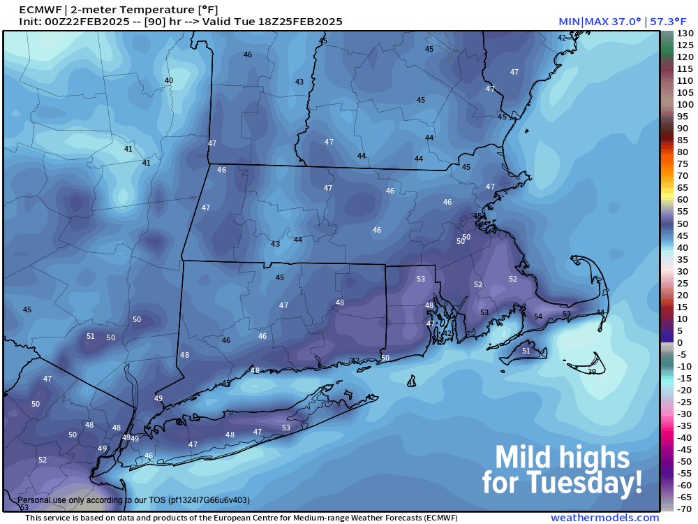
Tuesday is even milder (up, up we go!) with highs in the upper 30s to upper 40s under mostly cloudy skies as another system moves north of us at night with lows near freezing with a few spot showers possible (no big whoop!)
—————–
SECURELY BECOME A 2025 WEATHER NUT SUPPORTER TODAY
–> When 4% of readers support at any level,
this community weather resource remains active:
(Secure options include Cards, PayPal, Venmo, Check)
—————–
Wednesday is by far the pick of the upcoming week as high pressure crests through the region, providing what looks like a mostly sunny day with highs again in the upper 30s to upper 40s, with potential for Hartford, CT to hit 50º! Lows will be near freezing once again.
By Wednesday night into Thursday clouds will be increasing as a stronger system with a cold front approaching the region, bringing a period of mixed showers changing to rain on Thursday with highs in the 40s before the front works through the region.
Thursday night lows will dip down into the 20s, which will be followed by colder temps Friday, and especially over the weekend as a colder air mass works into our region behind the front.
This *could* be a setup for a winter storm next weekend, or by early the following week, but much uncertainty remains so I will monitor it and keep you updated.
Personally, I think there is one more winter storm lurking in the atmosphere’s tank for southern New England during the first half of March before we really start to see milder conditions becoming more pronounced in the second half of the month.
But, as we know, March can throw all sorts of meteorological curveballs at us!
Have a great day, and if you find my hyperlocal and interactive reporting work is helpful to you, please can chip in what you can at the link below to help support it through 2025… thank you so much for your readership and support, Dave Hayes.
SECURELY BECOME A 2025 WEATHER NUT SUPPORTER TODAY
–> When 4% of readers support at any level,
this community weather resource remains active:
(Secure options include Cards, PayPal, Venmo, Check)
“Follow your bliss and the universe will open doors for you where there were only walls.”
― Joseph Campbell