
SECURELY BECOME A 2025 WEATHER NUT SUPPORTER TODAY
–> When 4% of readers support at any level,
this community weather resource remains active in 2025:
(Secure options include Cards, PayPal, Venmo, Check)
~~~~~~~~~~~~~~~~~~
TABLE OF CONTENTS
* Daily Celestials (Sun/Moon Data)
* Sponsor Note
* Morning Discussion
* TIP: Scroll below for sections, or read all
~~~~~~~~~~~~~~~~~~~~~~
YOUR DAILY CELESTIALS
~~~~~~~~~~~~~~~~~~~~~~
STAR:
–OUR STAR ROSE AT: 6:37am this morning
–OUR STAR SETS AT: 5:30pm this evening
–TOTAL DAYLIGHT TIME: 10 hours and 53 minutes
MOON:
–OUR MOON SETS AT:10:36am this morning
–MOON SET DIRECTION: Southwest
–OUR MOON RISES AT: 3:02am tonight
–MOON RISE DIRECTION: Southeast
–MOON PHASE: Waning Crescent (42.7%)
~~~~~~~~~~~~~~~~~~~~~~
A NOTE FROM OUR SPONSOR
~~~~~~~~~~~~~~~~~~~~~~
Dave Hayes The Weather Nut is Sponsored by Individual Community Members, Patrons, and Tandem Bagel Company… No matter the weather, Tandem Bagel is always there for you at several valley locations to make your mornings brighter! With *New Pizza Bagels(!)*, along with bagels baked fresh daily (including Gluten-Free options), house-whipped cream cheese, coffee, and tons of lunch options, Tandem is the perfect quick stop for lunch, breakfast, or a coffee and bagel to go.
You can either 1) visit them in Easthampton, Northampton, Hadley, Florence, and/or West Springfield, 2) hire them to cater your next event, or 3) use their super-streamlined online ordering tool by visiting their website and clicking the “Catering” or “Order Online” links.
~~~~~~~~~~~~~~~~~~~~~~
YOUR MORNING DISCUSSION
~~~~~~~~~~~~~~~~~~~~~~
Good morning folks, while we’re breaking the back of this winter season, so to speak, that doesn’t mean we’re done with winter weather, which I think we’ll see some more of by next weekend or the following week.
But for now, we’re going to celebrate our tiny little wins in the form of a lovely weekend with more seasonable temperatures developing, periods of sunshine, and temps rising up into the mid 30s to mid 40s by early to the middle of next week which (in combination with the rising sun angle of late February) will help to slowly being a thawing process from deep winter and snow/ice pack.
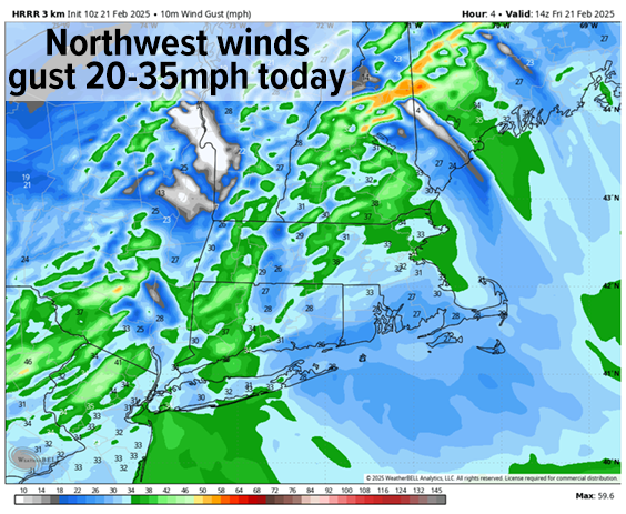
For today, we’re stuck between high pressure moving toward the lower Mid-Atlantic coastline with deepening low pressure which grazed Cape Cod and is blowing up over Cape Breton. This will tighten the pressure gradient and cause northwest winds to gust 20-35mph, especially this morning into early afternoon before slackening later.
Highs will reach the 20s to near 30º under mostly sunny skies, with lows crashing into the single digits as winds calm and radiational cooling takes effect. In fact, some areas may dip below zero for a time by early Saturday morning.
——————-
SECURELY BECOME A 2025 WEATHER NUT SUPPORTER TODAY
–> When 4% of readers support at any level,
this community weather resource remains active in 2025:
(Secure options include Cards, PayPal, Venmo, Check)
——————-
Please continue to watch for black ice formation each late night / early morning through the weekend as we’ll refreeze any melting each night.
For the weekend, as high pressure starts passing south of us and putting us into a more southwest flow we will start moving in the right direction toward more seasonable weather conditions.
Highs will reach the low to mid 30s under mostly sunny skies with lows in the mid to upper teens, so that’s already an improvement with our temperatures.
On Sunday, we continue to rise into the mid to upper 30s under partly sunny skies with lows dropping into the upper teens.
By Monday I’ll be watching a weak Clipper system approaching from the Great Lakes which will pass mostly to our north Monday night into Tuesday, bringing mixed rain or snow showers mainly Monday night north of the Pike in MA, VT and NH.
Highs Monday will keep climbing into the upper 30s to low 40s with lows near freezing, followed Tuesday by highs in the upper 30s to mid 40s as that system keeps trucking by, and brightening our skies by afternoon. Lows will fall to either side of freezing both nights.
Wednesday looks like the pick of the week to me, with more sunshine and highs potentially well into the 40s! Low temps would then fall into the upper 20s ahead of another fairly weak system for Thursday that may bring a mix of rain with some elevation snow.
More importantly, that storm will usher in much colder air buy Friday and into next weekend, and there are a couple of wintry storm systems that my impact us, so I will keep you updated on all of it!
Have a great day, and if you’d like to keep me in your service through 2025, you can chip in any comfortable one-time or monthly amount at the secure link to my site below:
——————-
SECURELY BECOME A 2025 WEATHER NUT SUPPORTER TODAY
–> When 4% of readers support at any level,
this community weather resource remains active in 2025:
(Secure options include Cards, PayPal, Venmo, Check)
“Follow your bliss and the universe will open doors for you where there were only walls.”
― Joseph Campbell