
SECURELY BECOME A 2025 WEATHER NUT SUPPORTER TODAY
–> When 4% of readers support at any level,
this community weather resource remains active in 2025:
(Secure options include Cards, PayPal, Venmo, Check)
~~~~~~~~~~~~~~~~~~
TABLE OF CONTENTS
* Daily Celestials (Sun/Moon Data)
* Sponsor Note
* Morning Discussion
* TIP: Scroll below for sections, or read all
~~~~~~~~~~~~~~~~~~~~~~
YOUR DAILY CELESTIALS
~~~~~~~~~~~~~~~~~~~~~~
STAR:
–OUR STAR ROSE AT: 6:38am this morning
–OUR STAR SETS AT: 5:29pm this evening
–TOTAL DAYLIGHT TIME: 10 hours and 51 minutes
MOON:
–OUR MOON SETS AT: 9:58am this morning
–MOON SET DIRECTION: Southwest
–OUR MOON RISES AT: 1:59am tonight
–MOON RISE DIRECTION: Southeast
–MOON PHASE: Waning Gibbous (52.4%)
~~~~~~~~~~~~~~~~~~~~~~
A NOTE FROM OUR SPONSOR
~~~~~~~~~~~~~~~~~~~~~~
Dave Hayes The Weather Nut is Sponsored by Individual Community Members, Patrons, and Tandem Bagel Company… No matter the weather, Tandem Bagel is always there for you at several valley locations to make your mornings brighter! With *New Pizza Bagels(!)*, along with bagels baked fresh daily (including Gluten-Free options), house-whipped cream cheese, coffee, and tons of lunch options, Tandem is the perfect quick stop for lunch, breakfast, or a coffee and bagel to go.
You can either 1) visit them in Easthampton, Northampton, Hadley, Florence, and/or West Springfield, 2) hire them to cater your next event, or 3) use their super-streamlined online ordering tool by visiting their website and clicking the “Catering” or “Order Online” links.
~~~~~~~~~~~~~~~~~~~~~~
YOUR MORNING DISCUSSION
~~~~~~~~~~~~~~~~~~~~~~
Good morning folks, we’ve got a very chilly start today with temps in the single digits above and below zero with some low teens as well.
To our south is a snowstorm that will graze far southeast MA with light accumulating snow, and to our west is a forward-leaning upper trough that will keep pushing east, and keep our storm away from any WMass regional impacts.
However, a few widely scattered snow showers are possible as the upper level system comes east and causes increasing clouds by this afternoon into the evening.
Highs will reach the low to upper 20s, with lows tonight in the low to mid teens with cloudier skies.
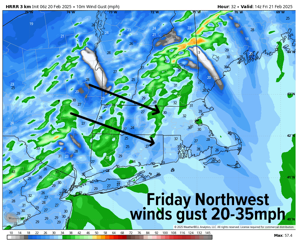
For Friday, that coastal storm tracks east and pulls colder air into the region on gusty northwest winds, reaching speeds of 20-35mph at times, so no wind headlines should be hoisted.
Sunshine will be abundant and highs will climb into the 20s, and drop down into the single digits before we can finally say goodbye to this persistent, cold winter pattern that we’ve been stuck in for a good two months now.
——————-
SECURELY BECOME A 2025 WEATHER NUT SUPPORTER TODAY
–> When 4% of readers support at any level,
this community weather resource remains active in 2025:
(Secure options include Cards, PayPal, Venmo, Check)
——————-
On Saturday, our temps will start steadily climbing as high pressure begins to move in from the west, relax the pressure gradient, lighten our wind, and pass south of us, which will begin a multi-day period into the middle of next week where temps moderate and slowly warm to levels we haven’t seen in a while.
Mostly sunny skies will rule Saturday with highs in the upper 20s to mid 30s, and lows in the teens.
Sunday looks more like a partly sunny day but with milder highs reaching the mid to upper 30s, so some melting with the higher sun angle will slowly begin. Lows will also be in the teens.
The Monday through Wednesday period looks even milder with highs climbing into the mid 30s to mid 40s through this period, in the middle of which a weak Alberta Clipper will bring a bit of snow shower activity late Monday night, changing to rain showers on Tuesday. This is subject to change, but that’s our next inclement event, albeit a weak one.
Beyond that, there are signals somewhere between Thursday night and Saturday for a potential winter storm with colder air moving back in, but folks, the balloon that has been the Winter of 2024-25 to date has been pricked, make no mistake.
We’re through the core of it from what I’m seeing, though that doesn’t mean we won’t see fluctuations in temperature and a chance at a couple of more winter storm potentials before we more fully flip the calendar and start heading toward the Vernal Equinox, a/k/a SPRING! :-)
Have a great day, and if you’d like to keep me in your service through 2025, you can chip in any comfortable one-time or monthly amount at the secure link to my site below:
——————-
SECURELY BECOME A 2025 WEATHER NUT SUPPORTER TODAY
–> When 4% of readers support at any level,
this community weather resource remains active in 2025:
(Secure options include Cards, PayPal, Venmo, Check)
“Follow your bliss and the universe will open doors for you where there were only walls.”
― Joseph Campbell