
SECURELY BECOME A 2025 WEATHER NUT SUPPORTER TODAY
–> When 4% of readers support at any level,
this community weather resource remains active:
(Secure options include Cards, PayPal, Venmo, Check)
~~~~~~~~~~~~~~~~~~
TABLE OF CONTENTS
* Daily Celestials (Sun/Moon Data)
* Sponsor Section
* Morning Discussion
* TIP: Scroll to your section, or read all
~~~~~~~~~~~~~~~~~~~~~~
YOUR DAILY CELESTIALS
~~~~~~~~~~~~~~~~~~~~~~
STAR:
–OUR STAR ROSE AT: 6:45am this morning
–OUR STAR SETS AT: 5:23pm this evening
–TOTAL DAYLIGHT TIME: 10 hours and 38 minutes
MOON:
–OUR MOON RISES AT: 8:42pm tonight
–MOON RISE DIRECTION: East
–OUR MOON SETS AT: 8:24am tomorrow morning
–MOON SET DIRECTION: West
–MOON PHASE: Waning Gibbous (91.7%)
~~~~~~~~~~~~~~~~~~~~~~
>>> A NOTE FROM OUR WEEKEND SPONSOR <<<
Dave Hayes The Weather Nut is Sponsored by Individual Community Members, Patrons, and Gerard, Ghazey & Bates, P.C.
GGBPC is a Northampton-based law firm and is the area’s premier estate and tax planning provider. The firm specializes in Estate Planning, Elder Law, and Tax Law, so be sure to contact GGBPC today to see how they can help you.
Simply click the following link to their secure website.
~~~~~~~~~~~~~~~~~~~~~~
YOUR MORNING DISCUSSION
~~~~~~~~~~~~~~~~~~~~~~
Good morning folks, we have as dynamic a winter pattern imminently set to run through the region as I’ve seen in many years tonight through Tuesday morning with a combination of accumulating snow, sleet, the most substantial ice accretion via freezing rain that we’ve seen this season, thunder(!) and downpours, and potentially the strongest wind gusts we’ve seen this season for late Sunday night, but especially on Monday when numerous power outages are possible, especially in the high terrain of the Berkshires, western hilltowns, Worcester highlands back into eastern Franklin County and up into southern VT and southwest NH in the mountains where gusts could pin 65mph.
It’s a lot to cover, it’s very complex, and I will do my best to parse out all of the impacts and timing and location of those impacts below.
SETUP
For today, early filtered and/or partial sunshine will give way to incoming clouds with highs only reaching the upper 20s to low 30s as a warm front floats our way, connected to a storm still taking shape down over the Mississippi River Valley.
That storm will track northeast to PA and NY by Sunday and then redevelop in the Gulf of Maine by Sunday evening, deepening rapidly and spread all precipitation types through the greater WMass region for a literal potpourri of precipitation.
SNOW ONSET
As skies become overcast, our first snow showers should arrive between 3-7pm from west to east. The wider range is there because it’s dry ahead of the incoming snow, so some virga (i.e. snow that evaporates aloft before reaching the ground) will occur until the column saturates to allow snow to the ground.
After 6pm or 7pm, the snow should be come steadier and will fall moderately to perhaps briefly heavy at times into the early pre-dawn hours.
With cold temps in place and lows dropping into the low to mid 20s, roads will become snow covered and slippery tonight, so give yourself extra time if you are heading for a night out on the town.
ICING IS INEVITABLE / CHANGE TIMES
Our storm tonight will be WELL southwest of us still with no secondary low forming until late Sunday, so this positioning with counterclockwise circulation around that low will sweep milder air up from the south and slam it into the cold air dome at the surface and be forced to rise up and over it.
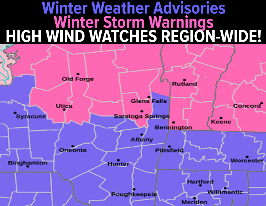
As we work through the pre-dawn hours, snow will be changing to sleet and then freezing rain as we get towards dawn south of the Route 2 corridor in northern CT and much of WMass and CMass, and by 7am we should still be seeing accumulating snow in far northern MA (northern Berkshires, northern Franklin County, northern Worcester County) up into SVT and SWNH, but sleet will soon start to mix in even in those northern areas through the morning, changing to freezing rain everywhere by noon, with plain rain at that time possible up into Holyoke/Springfield points south.
The afternoon should also see a steadier precipitation shield break into heavier clusters of scattered showers and even downpours, and I can’t rule out a rumble of thunder!!
Does anyone want to say ThunderFreezingRain 10 times fast?
I guess there’s a first time for everything, as I did see the ThunderSleet (my new band name, by the way) about 10 years back.
—————–
SECURELY BECOME A 2025 WEATHER NUT SUPPORTER TODAY
–> When 4% of readers support at any level,
this community weather resource remains active:
(Secure options include Cards, PayPal, Venmo, Check)
—————–
FREEZING RAIN / ICE ENCASEMENT SUNDAY
The bottom line is that highs tomorrow should hang in the upper 20s to low 30s north of the Pike, which would means freezing rain periods will continue in the high terrain of the northern Litchfield Hills, Berkshires, western hilltowns, and northern half of the valley from about Northampton/Amherst northward (though I could see warmer air turning even the Route 9 corridor in MA to a plain rain for a time).
Freezing rain periods should also continue in much of CMass and of course SVT and SWNH, with plain rain continuing from about Holyoke south to Hartford on east through southern CMass and northeast CT, south of the Pike mainly.
Substantial ice accretions (radial ice glaze) in the amount of a quarter to half an inch are possible (maybe even a little more) and the weight of that ice could cause isolated power outages by Sunday afternoon and evening.
Most of us should see ice accretion of a tenth to a quarter of an inch, and regardless of who exactly gets what, what is for sure is that we haven’t seen a more widespread ice event like this during this winter season.
In addition, northeast winds will kick up behind the secondary low and gust 25-40mph Sunday evening as it passes east of us, causing more branches encased in heavy ice to snap and possibly take some lines down.
SNOW/SLEET AMOUNTS
I am sticking with 2-5” of snow in central/southern Berkshire County, southernmost Franklin County, Hampshire and Hampden Counties and southern CMass down through all of northern CT.
North of there, in the northern Berkshires, northern Franklin County (including Greenfield), northern CMass and SVT and SWNH I am sticking with 5-10” of snow, though I think a 10” amount would be an outlier before sleet and freezing rain sweeps north into those areas after dawn on Sunday morning.
IN COMES THE WIND!
Lows will dip into the mid teens to low 20s, and then a sharp Arctic cold front will sweep the region from northwest to southeast early Monday morning as our Gulf of Maine secondary low deepens rapidly and powerfully pulls air in behind it like a vacuum, which will kick up upslope snow showers into the Berkshires and SVT with more light accumulations on Monday.
The wind will back around from northeast to the west, and as Monday morning moves along, it looks like the wind is going to truly trip.
I haven’t see High Wind Watches posted for the entire greater WMass region in a very long time, and we could see westerly gusts of 40-65mph, widespread.
With new ice accretion on trees and lines, and just with wind of the magnitude alone, I believe we are going to see scattered to numerous power outages on Monday morning into Monday afternoon, which is not good because an Arctic blast of air is what is driving this wind.
This means temps are going to crash from the 20s down into the single digits and teens with breezy conditions continuing Monday night, and wind chills near or below zero, which may prompt Cold Weather Advisories by tomorrow night for Monday night into early Tuesday morning.
All this to say, we have a ton of dynamic weather changes moving through our region over the next 48 hours!
Not only that, but after a couple of cold, fair weather days on Tuesday and Wednesday, I continue to note a stronger signal for a coastal snowy nor’easter for Thursday afternoon and night, so please keep it here throughout as I’ll be all over what’s coming our way, and if my hyperlocal and interactive reporting work is helpful to you, it’s up to you to chip in what you can at the link below to help me continue through 2025… thank you so much for your readership and support, Dave Hayes.
SECURELY BECOME A 2025 WEATHER NUT SUPPORTER TODAY
–> When 4% of readers support at any level,
this community weather resource remains active:
(Secure options include Cards, PayPal, Venmo, Check)
“Follow your bliss and the universe will open doors for you where there were only walls.”
― Joseph Campbell