
SECURELY BECOME A 2025 SUPPORTER TODAY
–> When 4% of readers support at any level,
this community weather resource can continue:
(Secure options include Cards, PayPal, Venmo, Check)
~~~~~~~~~~~~~~~~~~
TABLE OF CONTENTS
* Daily Celestials (Sun/Moon Data)
* Sponsor Note
* Morning Discussion
* TIP: Scroll below for sections, or read all
~~~~~~~~~~~~~~~~~~~~~~
YOUR DAILY CELESTIALS
~~~~~~~~~~~~~~~~~~~~~~
STAR:
–OUR STAR ROSE AT: 6:49am this morning
–OUR STAR SETS AT: 5:19pm this evening
–TOTAL DAYLIGHT TIME: 10 hours and 30 minutes
MOON:
–OUR MOON RISES AT: 5:31pm this afternoon
–MOON RISE DIRECTION: East-Northeast
–OUR MOON SETS AT: 7:29am tomorrow morning
–MOON SET DIRECTION: West-Northwest
–MOON PHASE: Waning Gibbous (99.8%)
~~~~~~~~~~~~~~~~~~~~~~
A NOTE FROM OUR SPONSOR
~~~~~~~~~~~~~~~~~~~~~~
Dave Hayes The Weather Nut is Sponsored by Individual Community Members, Patrons, and Tandem Bagel Company… No matter the weather, Tandem Bagel is always there for you at several valley locations to make your mornings brighter! With *New Pizza Bagels(!)*, along with bagels baked fresh daily (including Gluten-Free options), house-whipped cream cheese, coffee, and tons of lunch options, Tandem is the perfect quick stop for lunch, breakfast, or a coffee and bagel to go.
You can either 1) visit them in Easthampton, Northampton, Hadley, Florence, and/or West Springfield, 2) hire them to cater your next event, or 3) use their super-streamlined online ordering tool by visiting their website and clicking the “Catering” or “Order Online” links.
~~~~~~~~~~~~~~~~~~~~~~
YOUR MORNING DISCUSSION
~~~~~~~~~~~~~~~~~~~~~~
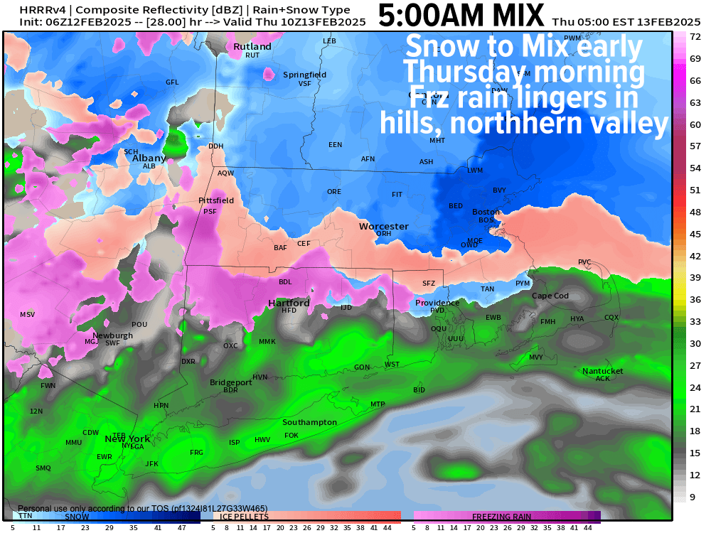
Good morning everybody, we’re starting off in the single digits and teens in northern WMass/CMass up into SVT/SWNH with upper teens to 20s in southern WMass/CMass down into northern CT after some snow showers passed through central CT/RI overnight.
A cold front is weakening as it floats south into our region, and at the same time our next storm system will be slowly strengthening down in the Deep South and lifting northeast today, along and just west of the Appalachian Mountains.
While we may get some partly sunny periods, the theme of the day is increasing cloudiness as our storm (which is destined to pass well west of us tonight) continues to spread it is cloud shield northeast into New England.
High temps will reach the upper 20s to mid 30s, and high pressure will be setting up to our northeast, which will provide what is called cold air damming to help lock in a southwestward surface-based cold drain for many of us in the greater WMass region into early Thursday morning.
This storm is going to be well west of us, so I expect the precip shield to be more showery and mottled, meaning we’ll see periods of light snow moving into the region between 8-11pm, or even snow showers.
Lows tonight will drop into the mid to upper 20s as milder air aloft surges northeast over our heads between 3-7am, flipping us from snow to sleet and freezing rain before and into the morning commute.
Some areas like SVT and SWNH will stay snow the longest, but I expect it to sleet or ice even there before the storm ships out towards noon, with a change to plain rain from about Holyoke south through Hartford in the lower Pioneer Valley.
——————-
SECURELY BECOME A 2025 SUPPORTER TODAY
–> When 4% of readers support at any level,
this community weather resource can continue:
(Secure options include Cards, PayPal, Venmo, Check)
——————-
Most of us in the CT River Valley from Northampton/Amherst south into northern CT will see a coating to an inch or so of snow/sleet, with 1-3” in the Berkshires, western hilltowns, northern CMass, Franklin County up into SVT/SWNH.
The timing of changeover is very hard to nail down specifically, but icing should last longest in the northern valley (Greenfield northward) and the western hilltowns, eastern Berkshire County, northern CMass, SVT, SWNH, etc.
This storm will lift out of here as dry air punches in from the southwest by mid day to early afternoon, with highs rising into the upper 30s to low 40s with a punch of mild air, with some sunshine later in the day.
Lows will drop into the upper teens to low 20s with a few lak effect snow showers in the Berkshires.
Friday looks like a lovely day, pick of the week perhaps!
High should reach the mid to upper 20s under full sunshine as high pressure passes through the region, with lows in the teens.
The weekend, unfortunately, is looking most inclement, but it is more likely than not going to deliver needed precipitation that will drain into surface soils when we move into Spring, so that’s a good thing.
Much needs to be refined, but essentially it looks like highs reach the upper 20s to low 30s with snow moving in by afternoon sometime, and snow will continue Saturday night and accumulate (how much, I don’t know yet).
Then sometime late Saturday night or into early Sunday morning, a storm is going to phase well WEST of us and rip into eastern Canada, which should produce a changeover to ice and then rain, possibly heavy at times for Sunday as highs climb above freezing.
I will refine this part of the forecast as we get closer. What I am more certain of is that behind this giant sweeping cold front and rain blast Sunday, we are going to see Arctic air blast back into the region for early next week, and I am quite concerned about very strong wind gusts up to 60mph causing some outages or tree damage in spots.
Temps will drop into the teens and 20s for highs with lows in the single digits above and below zero with wind chill impacts as well Monday night.
Beyond that, we have another storm signal to watch for Feb. 20th and then another Feb. 24th, so please know I will stay on top of it for you and keep tappity tap tapping away on my keyboard, the letters of which are disappearing into oblivion (apparently hit the M and N keys quite a bit!)
Have a great day, and if you’d like to keep me in your service, you can chip in any comfortable one-time or monthy amount at the secure link to my site below:
——————-
SECURELY BECOME A 2025 SUPPORTER TODAY
–> When 4% of readers support at any level,
this community weather resource can continue:
(Secure options include Cards, PayPal, Venmo, Check)
“Follow your bliss and the universe will open doors for you where there were only walls.”
― Joseph Campbell