
SECURELY BECOME A 2025
WEATHER NUT SUPPORTER TODAY
–> When 4% of readers support at any level,
this community weather resource remains active
(Secure options include Cards, PayPal, Venmo, Check)
~~~~~~~~~~~~~~~~~~
TABLE OF CONTENTS
* Daily Celestials (Sun/Moon Data)
* Sponsor Note
* Morning Discussion
* TIP: Scroll below for sections, or read all
~~~~~~~~~~~~~~~~~~~~~~
YOUR DAILY CELESTIALS
~~~~~~~~~~~~~~~~~~~~~~
STAR:
–OUR STAR ROSE AT: 6:56am this morning
–OUR STAR SETS AT: 5:13pm this evening
–TOTAL DAYLIGHT TIME: 10 hours and 17 minutes
MOON:
–OUR MOON RISES AT: 11:56am this morning
–MOON RISE DIRECTION: Northeast
–OUR MOON SETS AT: 4:28am tomorrow morning
–MOON SET DIRECTION: Northwest
–MOON PHASE: Waxing Gibbous (73.4%)
~~~~~~~~~~~~~~~~~~~~~~
A NOTE FROM OUR SPONSOR
~~~~~~~~~~~~~~~~~~~~~~
Dave Hayes The Weather Nut is Sponsored by Individual Community Members, Patrons, and Tandem Bagel Company… No matter the weather, Tandem Bagel is always there for you at several valley locations to make your mornings brighter! With *New Pizza Bagels(!)*, along with bagels baked fresh daily (including Gluten-Free options), house-whipped cream cheese, coffee, and tons of lunch options, Tandem is the perfect quick stop for lunch, breakfast, or a coffee and bagel to go.
You can either 1) visit them in Easthampton, Northampton, Hadley, Florence, and/or West Springfield, 2) hire them to cater your next event, or 3) use their super-streamlined online ordering tool by visiting their website and clicking the “Catering” or “Order Online” links.
~~~~~~~~~~~~~~~~~~~~~~
YOUR MORNING DISCUSSION
~~~~~~~~~~~~~~~~~~~~~~
Good morning folks, we’ve got 48-60 hours of dynamic and active weather incoming, so I’m going to hop into TheBulletizationMobile(TM) and rip through the greater WMass region, casting double–dashes around with great reckless abandon to disseminate and seemingly endless amount of salient weather points of which I want you all to be aware:
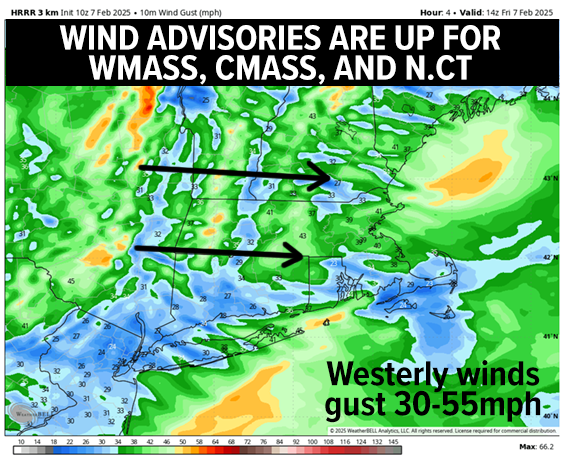
–Scattered snow showers and possibly a brief squall are sweeping east-southeast into WMass, northwest CT and southern VT this morning
–This is associated with a cold front that has already popped a 58mph wind gust in Albany, NY, with gusts over 40mph in SVT already
–Wind Advisories are up for SVT. WMass, CMass and N.CT this morning for gusts 30-55mph at times, especially this morning, slackening a bit by later afternoon
–Highs will reach the mid 20s to mid 30s with more clouds than sun expected today, again with scattered snow showers or flurries possible, and some fresh coatings in the Berkshires/SVT early this morning
–By tonight, lows will drop into the teens under mostly cloudy skies with westerly winds slackening to 15-30mph gusts at times
–For Saturday, wind should become light as brief high pressure passes to our south, with highs in the mid 20s to mid 30s once again
–Clouds will increase late in the day in response to a storm gathering strength near the Ohio Valley, and tracking towards the New Jersey coast
–We’ll have plenty of cold air in place at all levels of the atmosphere, and while the track is not set in stone, the storm looks to exit the New Jersey coastline, and track east over The Benchmark, a point about 80 miles south of Nantucket which classically brings snowstorms into southern New England
–This will spread accumulating snow of moderate to at times heavy intensity into the Berkshires, southwest VT and northwest CT sometime between 7-9pm, then pressing east
——————-
SECURELY BECOME A 2025
WEATHER NUT SUPPORTER TODAY
–> When 4% of readers support at any level,
this community weather resource remains active
(Secure options include Cards, PayPal, Venmo, Check)
——————-
–It will be snowing throughout the greater WMass region before midnight, and with lows expected to dip into the low to mid 20s
–With the storm tracking so far south, there will be no mix with ice or rain, this one will be all snow
–It will snow one inch per hour at times overnight with the brunt of the snow falling about 11pm to 5am
–I expect a widespread 4-8” of snow at this time, with up to 10” in some spots
–If the track trended further south, amounts would go down but I don’t expect that right now
–Steadiest snow wraps up early Sunday morning with scattered snow showers later in the morning to early afternoon, with highs in the upper 20s to mid 30s
–Lows Sunday night as dig out and clear out will drop into the upper single digits to mid teens
–Monday looks lovely with highs in the mid 20s to low 30s under mostly sunny skies as high pressure builds in briefly, and I expect lows temps to bottom out into the single digits once again
–By Tuesday, we’re likely getting ready for another snowstorm as couds increase and highs again rise into the mid 20s to low 30s
–Snow may arrive around sunset and snow at night with additional accumulations, and yet another storm may follow on this one’s heels by later in the week with more snow possible
We’re in a very busy and impactful winter pattern folks, once that we have not seen in a number of years, so please keep it here and I will update you on all of it, and can continue to do that with your support during my 11th annuyal support drive, as I’ve tried to keep this as a community weather resource without a paywall for over a decade now… click below and have a great day!
——————-
SECURELY BECOME A 2025
WEATHER NUT SUPPORTER TODAY
–> When 4% of readers support at any level,
this community weather resource remains active
(Secure options include Cards, PayPal, Venmo, Check)
“Follow your bliss and the universe will open doors for you where there were only walls.”
― Joseph Campbell