
SECURELY BECOME A 2025 SUPPORTER TODAY
–> When 4% of readers contribute at any level,
this community resource can remain active & vital:
(Secure options include Cards, PayPal, Venmo, Check)
~~~~~~~~~~~~~~~~~~~~~~
TABLE OF CONTENTS
* Daily Celestials (Sun/Moon Data)
* Sponsor Note
* Morning Discussion
* TIP: Scroll below for sections, or read all
~~~~~~~~~~~~~~~~~~~~~~
YOUR DAILY CELESTIALS
~~~~~~~~~~~~~~~~~~~~~~
STAR:
–OUR STAR RISES AT: 6:59am this morning
–OUR STAR SETS AT: 5:09pm this evening
–TOTAL DAYLIGHT TIME: 10 hours and 10 minutes
MOON:
–OUR MOON RISES AT: 10:01am this morning
–MOON RISE DIRECTION: East-Northeast
–OUR MOON SETS AT: 12:51am tomorrow morning
–MOON SET DIRECTION: West-Northwest
–MOON PHASE: Waxing Crescent (40.6%)
~~~~~~~~~~~~~~~~~~~~~~
A NOTE FROM OUR SPONSOR
~~~~~~~~~~~~~~~~~~~~~~
Dave Hayes The Weather Nut is Sponsored by Individual Community Members, Patrons, and Tandem Bagel Company… No matter the weather, Tandem Bagel is always there for you at several valley locations to make your mornings brighter! With *New Pizza Bagels(!)*, along with bagels baked fresh daily (including Gluten-Free options), house-whipped cream cheese, coffee, and tons of lunch options, Tandem is the perfect quick stop for lunch, breakfast, or a coffee and bagel to go.
You can either 1) visit them in Easthampton, Northampton, Hadley, Florence, and/or West Springfield, 2) hire them to cater your next event, or 3) use their super-streamlined online ordering tool by visiting their website and clicking the “Catering” or “Order Online” links.
~~~~~~~~~~~~~~~~~~~~~~
YOUR MORNING DISCUSSION
~~~~~~~~~~~~~~~~~~~~~~
Good morning folks, the Earth is still spinning, our solar system is still spinning, our galaxy is still spinning, and the Universe is still shot through with hundreds of billions of galaxies all meandering around, so I’d say it’s pretty amazing we’re even here, and able to get around and even have a smile or a laugh or a meal or a moment of comfort in a given day. The whole thing is truly a miracle, really, and I’m glad we all found each other in this cosmic circumstance.
In terms of the interface of Earth and the Cosmos (i.e. our weather), we’re pretty mild this morning, with temps in the upper 20s and 30s with mostly cloudy skies for the moment.
I think we’ll see a mix of sun and clouds today as a cold front continues to pull further southeast and out to sea. What that will do is begin to pull colder air in behind it and through the greater WMass region.
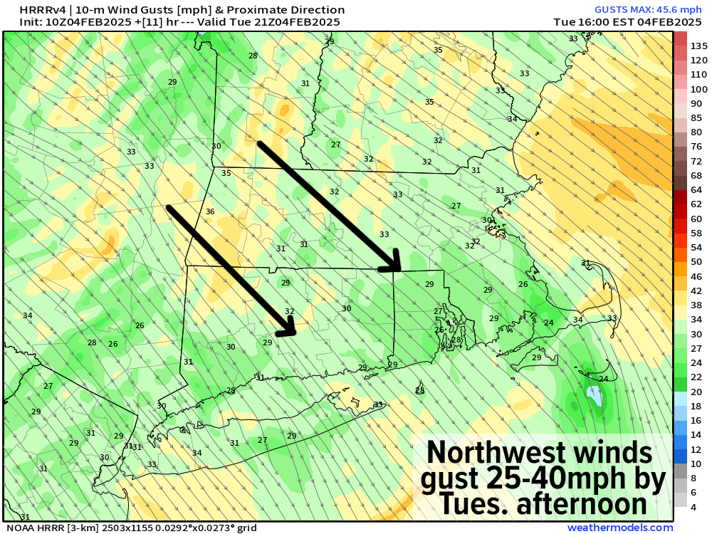
What that means is that our current temps are more or less going to become our high temps for the day, and as northwest winds pick up by afternoon and gust 25-40mph, our day will become more blustery and colder, as temps drop this afternoon, plummeting into the single digits and teens tonight, which will feature partly cloudy skies and breezy conditions early.
For Wednesday, a very nice but cold early February day is on tap with highs in the 20s under mostly sunny skies as wind continues to lighten given incoming high pressure. Lows will drop into the single digits to low teens as clouds increase.
Meanwhile, another winter storm system will be pushing east-northeast in zonal flow toward southern New England, and likely pass through CT/RI on Thursday.
——————-
SECURELY BECOME A 2025 SUPPORTER TODAY
–> When 4% of readers contribute at any level,
this community resource can remain active & vital:
(Secure options include Cards, PayPal, Venmo, Check)
——————-
While it’s possible that the early morning commute may be largely unaffected, by mid-morning or so snow will break out and start accumulating quickly on very cold roads, and last through the morning.
Because the storm will possess a milder mid-level environment and will be tracking so close to us, we will likely see snow to change to sleet toward mid-day, contributing to travel headaches and slippery conditions.
By later afternoon and evening, we may even change to rain and/or brief freezing rain, but precipitation should be breaking into a more showery presentation and winding down.
Given all of this, I think that at this range, snow and sleet will be our main precip types (and for now, it kind of looks the same for late Saturday night into Sunday’s winter storm system as well).
Snow totals will likely be light, maybe around 1-3” or so with sleet pellets on top. Highs Thursday will reach the low to mid 30s with lows in the 20s as refreezing takes place with black ice possible.
For Friday and Saturday, a pair of seasonable winter days arrive with sunny skies and highs in the mid to upper 30s Friday, followed by lows in the teens. On Saturday, it’ll be colder with highs in the upper 20s to mid 30s as clouds start to increase ahead of our next storm system.
Again, for now Saturday night into Sunday looks to produce another snow and ice storm with more accumulations, but I will keep you updated on that as we get closer.
Have a great day and if you’d like to support my work and help keep me in your service, just click the secure link below for available options and thank you.
SECURELY BECOME A 2025 SUPPORTER TODAY
–> When 4% of readers contribute at any level,
this community resource can remain active & vital:
(Secure options include Cards, PayPal, Venmo, Check)
“Follow your bliss and the universe will open doors for you where there were only walls.”
― Joseph Campbell