
SECURELY BECOME A 2025 SUPPORTER TODAY
–> When 4% of readers contribute at any level,
this community resource can remain active & vital:
(Secure options include Cards, PayPal, Venmo, Check)
~~~~~~~~~~~~~~~~~~~~~~
TABLE OF CONTENTS
* Daily Celestials (Sun/Moon Data)
* Sponsor Note
* Morning Discussion
* TIP: Scroll below for sections, or read all
~~~~~~~~~~~~~~~~~~~~~~
YOUR DAILY CELESTIALS
~~~~~~~~~~~~~~~~~~~~~~
STAR:
–OUR STAR RISES AT: 7:00am this morning
–OUR STAR SETS AT: 5:08pm this evening
–TOTAL DAYLIGHT TIME: 10 hours and 8 minutes
MOON:
–OUR MOON RISES AT: 9:35am this morning
–MOON RISE DIRECTION: East-Northeast
–OUR MOON SETS AT: 11:34pm tonight
–MOON SET DIRECTION: West-Northwest
–MOON PHASE: Waxing Crescent (29.6%)
~~~~~~~~~~~~~~~~~~~~~~
A NOTE FROM OUR SPONSOR
~~~~~~~~~~~~~~~~~~~~~~
Dave Hayes The Weather Nut is Sponsored by Individual Community Members, Patrons, and Tandem Bagel Company… No matter the weather, Tandem Bagel is always there for you at several valley locations to make your mornings brighter! With *New Pizza Bagels(!)*, along with bagels baked fresh daily (including Gluten-Free options), house-whipped cream cheese, coffee, and tons of lunch options, Tandem is the perfect quick stop for lunch, breakfast, or a coffee and bagel to go.
You can either 1) visit them in Easthampton, Northampton, Hadley, Florence, and/or West Springfield, 2) hire them to cater your next event, or 3) use their super-streamlined online ordering tool by visiting their website and clicking the “Catering” or “Order Online” links.
~~~~~~~~~~~~~~~~~~~~~~
YOUR MORNING DISCUSSION
~~~~~~~~~~~~~~~~~~~~~~
Good morning everybody, based on your snow total reports it seems like most of us came in around 1-3” overnight with some 4” reports coming in out of western Franklin County, so the 1-4” I offered for most of us came to pass, and it sure his gorgeous outside this morning.
Be careful heading out, because we had slippery ice caked on to some of our surfaces before this snow arrived, and it will be VERY slippery in spots, so be careful!
Fortunately in terms of ice, we have a mild day arriving with a mix of sun and clouds expected as a cold front start to approach the region later today.
Still, given that a warm front has passed through the region we’ve got mild southerly flow on the way which will push highs up into the mid 30s to mid 40s today from north (SVT) to south (NCT), with WMass/CMass mostly in the low 40s.
Thereafter, our aforementioned incoming cold front will be working into the region draped off of a primary low center that tracked well north of us last night which swung that snowy mid-level wave and warm front through our region. SCHWING!
As this happens, clouds will increase this evening, and some scattered snow or mixed snow showers will work into southern VT and southwest NH mostly. Northern MA (Berks, Franklin Wistah) should see a few mixed showers overnight as well with lows dropping into the mid 20s to mid 30s along with some patchy fog, so watch for freezing fog and isolated slippery spots in northern MA and SVT/SWNH late.
——————-
SECURELY BECOME A 2025 SUPPORTER TODAY
–> When 4% of readers contribute at any level,
this community resource can remain active & vital:
(Secure options include Cards, PayPal, Venmo, Check)
——————-
On Tuesday, our front is south of the region, but temps will crash more at night than during the day. Still, northwest winds will pick up and gust 20-35mph at times, ushering in the colder air. Highs will reach well into the 30s, and then crash later with lows plummeting into the upper single digits to teens so watch for black ice patches.
Wednesday looks lovely but cold with highs in the 20s under sunny skies with cold lows in the teens as clouds increase and snow arrives late at night.
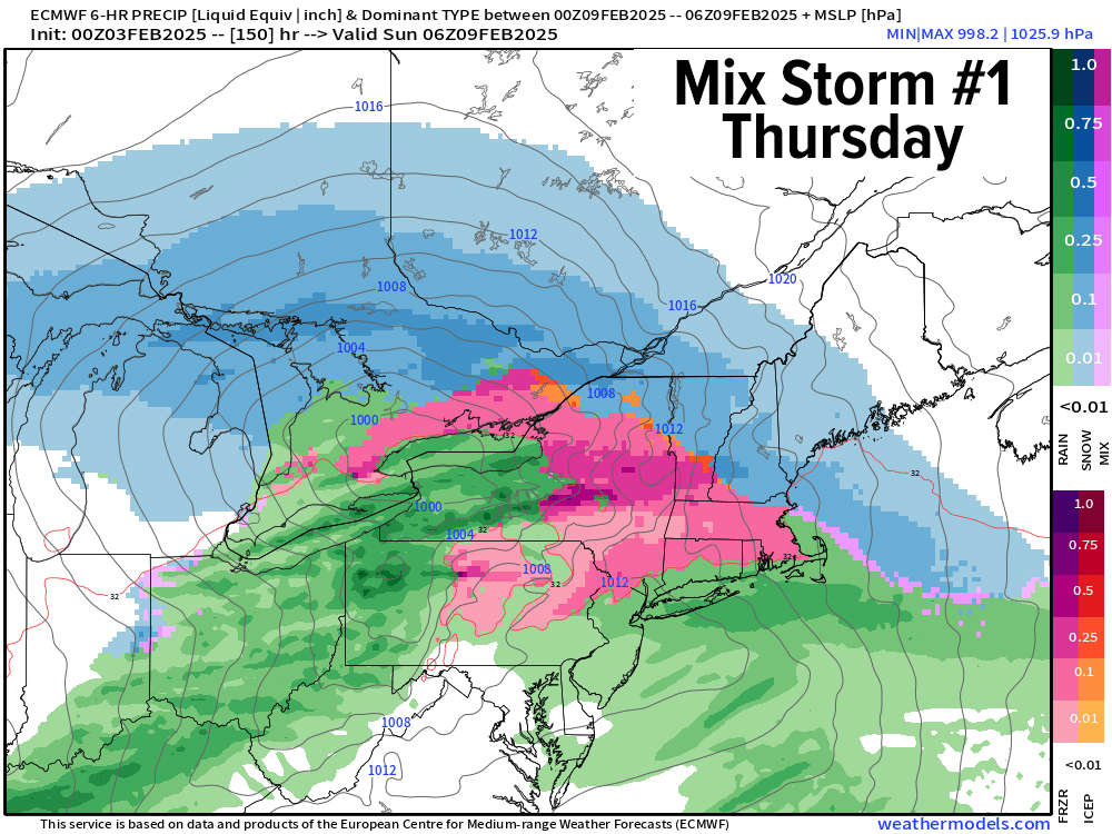
Thursday morning looks like a lousy commute right now with snow and/or ice continuing, so prepare to give yourself some extra travel time. If the storm tracks north of us without a strong-enough secondary low developing south of us, it *should* turn to rain later Thursday morning, but with temps in the teens, I think Thursday morning will be quite icy around here so please stay tuned for updates.
So Thursday looks like a wintry mix for now with snow to ice to rain (for some) with a low chance that it could be all snow with highs in the 30s to near 40º, and lows in the 20s at night with refreezing expected.
Friday looks lovely, like Wednesday, with partial sunshine, high pressure and highs in the upper 20s to mid 30s and lows dipping into the teens.
Then by the weekend, a stronger storm system will likely be working northeast toward the Mid-Atlantic coastline and may produce a full-on snowstorm in the greater WMass region, but again it will come down to track as the super Arctic cold of January has retreated more to the north, and so now we rely on storms riding that cold to the north, and warm to the south temperature boundary (a/k/a baroclinic boundary), such that if they track just south the tap the cold and pump the snow.
We shall see!
Have a great day and if you’d like to support my work and help keep me in your service, just click the secure link below for available options and thank you.
SECURELY BECOME A 2025 SUPPORTER TODAY
–> When 4% of readers contribute at any level,
this community resource can remain active & vital:
(Secure options include Cards, PayPal, Venmo, Check)
“Follow your bliss and the universe will open doors for you where there were only walls.”
― Joseph Campbell