
SECURELY BECOME A 2025 SUPPORTER TODAY
–> When 4% of readers contribute at any level,
this community resource can remain active & vital:
(Secure options include Cards, PayPal, Venmo, Check)
~~~~~~~~~~~~~~~~~~~~~~
TABLE OF CONTENTS
* Daily Celestials (Sun/Moon Data)
* Sponsor Section
* Morning Discussion
* TIP: Scroll to your section, or read all
~~~~~~~~~~~~~~~~~~~~~~
YOUR DAILY CELESTIALS
~~~~~~~~~~~~~~~~~~~~~~
STAR:
–OUR STAR RISES AT: 7:01am this morning
–OUR STAR SETS AT: 5:06pm this evening
–TOTAL DAYLIGHT TIME: 10 hours and 5 minutes
MOON:
–OUR MOON RISES AT: 9:12am this morning
–MOON RISE DIRECTION: East
–OUR MOON SETS AT: 10:17pm this afternoon
–MOON SET DIRECTION: West
–MOON PHASE: Waxing Crescent (19.9%)
~~~~~~~~~~~~~~~~~~~~~~
>>> A NOTE FROM OUR WEEKEND SPONSOR <<<
Dave Hayes The Weather Nut is Sponsored by Individual Community Members, Patrons, and Gerard, Ghazey & Bates, P.C.
GGBPC is a Northampton-based law firm and is the area’s premier estate and tax planning provider. The firm specializes in Estate Planning, Elder Law, and Tax Law, so be sure to contact GGBPC today to see how they can help you.
Simply click the this link to their secure website.
~~~~~~~~~~~~~~~~~~~~~~
YOUR MORNING DISCUSSION
~~~~~~~~~~~~~~~~~~~~~~
Good morning folks, we have a lovely morning out there, but it’s super cold!! Temps are in the single digits above and below zero and everything if frozen solid!
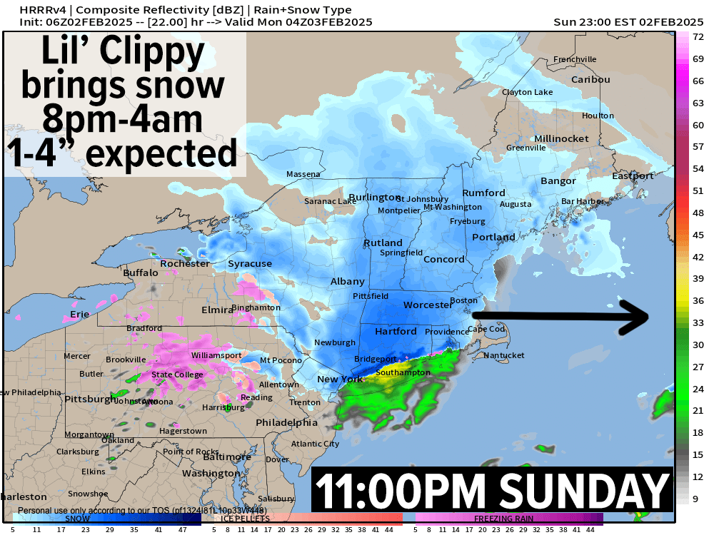
Mostly sunny skies become partly sunny and then sun will become filtered, and then clouds will overspread our region by afternoon as oour Alberta Clipper system approaches from the west.
I must pause here and say I LOVE these little snowmakers. We have not had them for years, and I am glad they are back. They are like little childhood friends, and they make me happy and keep me company, and…. Uhh, did I just type that? Oops, I guess the cat’s out of the bag… I’M A WEIRDO. :-p
So, highs climb into the mid to upper 20s today, and then after sunset we’ll see accumulating snow push into the region between 8-10pm from west to east (Berkshires to WISSSTAHH!!!!) and exit 2am-4am.
This storm will mostly drop 1-3” of snow by Monday morning for most of us, but there will be some 2-5” swaths, notably in the Berkshires (especially northeast from Route 9 up through north county), the western hilltowns, and SVT/SWNH.
Bust out the brooms, because it’ll be mostly fluffy and easier to push around.
Now, our storm passes north of us, which will drag a warm front through Monday morning, and allow temps to rise well into the mid 30s to mid 40s under mostly cloudy skies, so we’ll see some snow melt, and then some black ice refreezing at night with lows in the upper 20s to low 30s as a few mixed showers work into areas north of the Rt. 2 corridor as a cold front approaches.
——————-
SECURELY BECOME A 2025 SUPPORTER TODAY
–> When 4% of readers contribute at any level,
this community resource can remain active & vital:
(Secure options include Cards, PayPal, Venmo, Check)
——————-
On Tuesday, a cold front will swing through (seesaw weather!) and will kick up some northwest gusts of 20-35mph with mostly sunny skies developing. Highs will reach the 30s but then drop into the teens at night as colder air settles into the region.
This will set us up for a cold Wednesday with highs in the 25-30º range under mostly sunny skies, with lows expected to drop into the teens as our next winter storm tracks east-northeast out of the Ohio Valley.
Precip type is uncertain still, and while this could turn into an all-snow event, I still think there is a good chance we see a snow to mix and/or rain event late Wednesday night into Thursday.
Regardless, I think the Wednesday morning commute will be impacted with wintry precipitation, so I will keep you updated as we get closer. If it turns into an all-snow event, we could be talking a 3-6” type of snowfall, but that’s just to give you an idea that this would be a moderate level storm, not a blockbuster.
After Thursday’s storm (with highs in the 30s on Thursday), we take a pause with seasonable highs in the 30s expected through late week and lows in the upper teens to low 20s prior to ANOTHER potential storm for Saturday night which could be wintry as well.
A busy winter pattern is forming, so please know I’ll keep on top of it all, and keep you updated throughout! Have a great day and if you’d like to support my work and help keep me in your service, just click the secure link below for available options and thank you.
SECURELY BECOME A 2025 SUPPORTER TODAY
–> When 4% of readers contribute at any level,
this community resource can remain active & vital:
(Secure options include Cards, PayPal, Venmo, Check)
“Follow your bliss and the universe will open doors for you where there were only walls.”
― Joseph Campbell