
SECURELY BECOME A 2025 SUPPORTER TODAY
–> If 4% of readers contribute, this resource remains each year
(Options include Cards, PayPal, Venmo, or Check)
~~~~~~~~~~~~~~~~~~~~~~
TABLE OF CONTENTS
* Daily Celestials (Sun/Moon Data)
* Sponsor Section
* Morning Discussion
* TIP: Scroll to your section, or read all
~~~~~~~~~~~~~~~~~~~~~~
YOUR DAILY CELESTIALS
~~~~~~~~~~~~~~~~~~~~~~
STAR:
–OUR STAR RISES AT: 7:02am this morning
–OUR STAR SETS AT: 5:05pm this evening
–TOTAL DAYLIGHT TIME: 10 hours and 3 minutes
MOON:
–OUR MOON RISES AT: 8:50am this morning
–MOON RISE DIRECTION: East
–OUR MOON SETS AT: 9:02pm this afternoon
–MOON SET DIRECTION: West
–MOON PHASE: Waxing Crescent (11.4%)
~~~~~~~~~~~~~~~~~~~~~~
>>> A NOTE FROM OUR WEEKEND SPONSOR <<<
Dave Hayes The Weather Nut is Sponsored by Individual Community Members, Patrons, and Gerard, Ghazey & Bates, P.C.
GGBPC is a Northampton-based law firm and is the area’s premier estate and tax planning provider. The firm specializes in Estate Planning, Elder Law, and Tax Law, so be sure to contact GGBPC today to see how they can help you.
Simply click the this link to their secure website.
~~~~~~~~~~~~~~~~~~~~~~
YOUR MORNING DISCUSSION
~~~~~~~~~~~~~~~~~~~~~~
Good morning folks, to start off after my early evening report I did not expect that the precipitation shield would dissipate as early as it did.
As the storm developed to our south, a lot of the energy became focused southeast towards the low center which generated heavier precipitation away from our region. This dried up what I thought would help to generate light snow accumulations along and north of the Pike up toward the Route 2 corridor, but that didn’t come to pass for many of us.
Certainly, northern MA (the northern Berkshires, Franklin County, northern Worcester County on up to SVT and SWNH) panned out, as 2-6” of snow (with some sub-2” amounts) developed in a number of towns in those regions, but south of Route 2 it didn’t come together like I thought it would.
Moving forward, we do still have some patchy freezing drizzle and a bloom of light snow in Worcester County and parts of the Berkshires and Taconics with temps at or just below freezing, but we will see improvements moving forward this morning.
Do watch for slippery spots if you headed out with icing that formed overnight.
For the rest of our Saturday, improvements are on the way, but The Coldening is also on the way.
Sunshine will develop as we move through the day, but high temps are basically what we have right now. As northwest winds develop and gust to 30mph, colder air will be ushed into the region, with temps dropping during the afternoon and wind chills in the upper single digits to teens.
——————-
TAIKO VOTED “YES”… PERHAPS YOU WILL, TOO?
“Dave is constantly reviewing and updating with attention to all of our different little weather zones which can vary drastically. Plus, I love that the community of followers help each other know what road conditions and weather effects are in each location in real time! A truly community-centered service!!” –Taiko C.
–> Help Sustain this Community Weather Resource
–> Click securely to select from many support options
–> Click Here (Thank You)
——————-
For tonight, strong 1036mb high pressure moves east into the region and calms winds, and drops temps down to the single digits, and for some in northwest MA and southern VT, the single digits below zero as radiational cooling sets up shop.
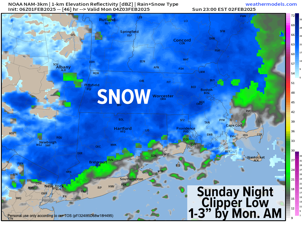
By Sunday, a partly sunny start will lead to clouds developing in the afternoon as highs climb into the upper 20s to low 30s with a light south wind developing due to the approach of our next Alberta Clipper low pressure system that will again pass north of us.
However, it will do so at night when we’re in the coldest part of the 24-hour cycle. With lows temps forecast to drop into the low to mid 20s, light snow will develop, with the steadiest pushing in about 6pm to midnight or so, which should lay down a coating up to 2”, maybe 3” in a few spots in northern MA.
This system will again mainly impact north of the Pike, with coatings or even no accumulation or a possible mix with rain south of the Pike, especially in northern CT.
The storm will shuffle out of here by Monday morning, and with milder air working in behind it, temps will rise into the upper 30s to mid 40s under partly sunny skies with a shower possible. Lows will dip down to near 30º.
Tuesday looks like a great day, with sunshine, high pressure, and highs in the 30s: a seasonable early February day, with lows dropping into the mid to upper teens.
By mid-week, another system will be approaching, but uncertainty remains as to whether it tracks over us or south of us, which will impact precipitation types. Expecting at least a mix to rain would make sense for now, but it could trend more wintry.
After that, guidance is starting to point to a busy storm pattern setting up, which could mean more snow for the area as move into the first and second weeks of February, so I will keep you updated on all of it.
Have a great day!
“Follow your bliss and the universe will open doors for you where there were only walls.”
― Joseph Campbell