
DAVE HAYES MOBILE WEATHER APP UPDATES
~~~~~~~~~~~~~~~~~~~~~~
TABLE OF CONTENTS
* Daily Celestials (Sun/Moon Data)
* Sponsor Note
* Morning Discussion
* TIP: Scroll below for sections, or read all
~~~~~~~~~~~~~~~~~~~~~~
YOUR DAILY CELESTIALS
~~~~~~~~~~~~~~~~~~~~~~
STAR:
–OUR STAR RISES AT: 7:04am this morning
–OUR STAR SETS AT: 5:04pm this evening
–TOTAL DAYLIGHT TIME: 10 hours!!!
MOON:
–OUR MOON RISES AT: 8:27am this morning
–MOON RISE DIRECTION: East-Southeast
–OUR MOON SETS AT: 7:46pm this afternoon
–MOON SET DIRECTION: West
–MOON PHASE: Waxing Crescent (5.1%)
~~~~~~~~~~~~~~~~~~~~~~
A NOTE FROM OUR SPONSOR
~~~~~~~~~~~~~~~~~~~~~~
Dave Hayes The Weather Nut is Sponsored by Individual Community Members, Patrons, and Tandem Bagel Company… No matter the weather, Tandem Bagel is always there for you at several valley locations to make your mornings brighter! With *New Pizza Bagels(!)*, along with bagels baked fresh daily (including Gluten-Free options), house-whipped cream cheese, coffee, and tons of lunch options, Tandem is the perfect quick stop for lunch, breakfast, or a coffee and bagel to go.
You can either 1) visit them in Easthampton, Northampton, Hadley, Florence, and/or West Springfield, 2) hire them to cater your next event, or 3) use their super-streamlined online ordering tool by visiting their website and clicking the “Catering” or “Order Online” links.
~~~~~~~~~~~~~~~~~~~~~~
YOUR MORNING DISCUSSION
~~~~~~~~~~~~~~~~~~~~~~
Good morning everybody, keep swimming, keep moving, keep trying to take care of yourself and your peeps, even when things are difficult, no matter the cause. Just keep moving forward the best you can.
As for our weather, aside from the western hilltowns, northern Berkshires and SVT (where teens remain for now), temps are coming up fairly quickly through the 20s and low to mid 30s ahead of our incoming frontal-based rainfall.
We’ve been cold for so long, that in some cases in the Litchfield Hills, Berkshires, SVT and even the western hilltowns, when rain arrives mid to late morning, there could be some freezing rain that develops and produces a glaze on surfaces, and as much as a tenth of an inch of ice accretion in some cases, so watch for slippery spots late morning into the mid-day in the high terrain west of I-91.
For the rest of us in the valley points east and south, we should see mainly rain today and through the afternoon and early evening, with around a half to three-quarters of an inch expected by tonight.
High temps should climb into the mid 30s to low 40s, but may hang in the low 30s up in southern VT west of the CT River Valley up that way, where we may mix all day and turn to snow in the southern Greens by or before sunset. Southern VT and southwest NH may see 2-4” of wet snow by tomorrow morning.
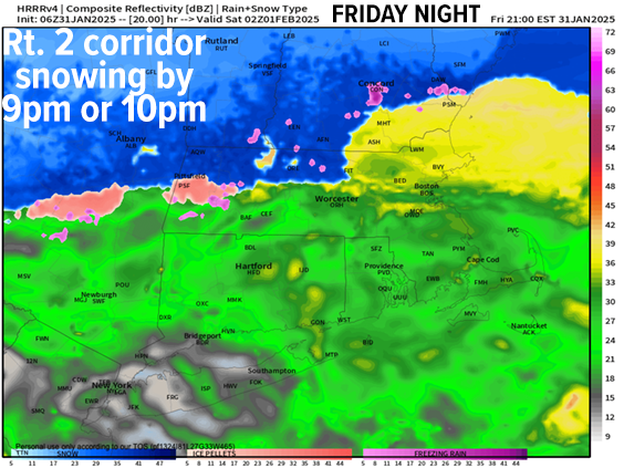
For the rest of us in WMass, CMass and northern CT, rain will continue this afternoon and into the early evening, but as our storm tracks east out of the Ohio Valley and south of New England early tonight, it will draw colder air from north to south into our region as it passes east of our longitude.
This southerly drain of cold air where flip winds from southwest today to northwest and north tonight and cause a change from rain to ice and snow to occur down through the Rt. 2 corridor between 8-11pm, and then down ot the Pike thereafter.
I think north of the Pike in WMass and CMass could see a coating to up to 2” (2” would be probably along and especially north of Rt. 2 in northern MA), with little to none south of the Pike.
I am also concerned for back end lighter precipitation in the form of freezing drizzle and light snow during the pre-dawn hours into very early Saturday morning, which may cause additional slippery spots, so be aware.
Lows tonight dip into the 20s.
For Saturday, we start drying out by mid-morning, and then should see sunshine develop behind the cold front, but even as highs reach the 20s to low 30s, temps will then fall behind the front through the afternoon with northwest winds gusting to 20mph.
Temps crash Saturday night, bottoming out into the single digits above AND below zero for a very cold Sunday morning! At least winds will be light.
For Sunday, skies will be partly sunny but clouds will increase ahead of the next Alberta Clipper system with high rising into the upper 20s to mid 30s.
Light snow will overspread the region, mainly north of the MA/CT state line by late afternoon or early evening as this storm takes a similar northerly track through northern New England like the last one did (the atmosphere has memory!)
A coating to 2” is expected north of the Pike by Monday morning, and while temps drop into the 20s overnight, we could actually see them come up enough by morning to switch us over to rain along and south of the Pike as a warm front will be working through the region and introducing us to a very mild Monday!
In fact, high temps may climb well into the 40s under partly sunny to mostly cloudy skies with lows near freezing.
Tuesday and Wednesday look cooler with fair weather expected and seasonable highs that should cap out into the low to mid 30s with lows in the low 20s.
By Wednesday afternoon or night into Thursday we could see another storm system that will pass northwest of us. Usually that track means rain, but with cold-enough air in place we could see some snow and ice Wednesday night transitioning to rain showers by Thursday, but I will update on that potential system as we get closer.
Have a great day!
DAVE HAYES MOBILE WEATHER APP UPDATES
“Follow your bliss and the universe will open doors for you where there were only walls.”
― Joseph Campbell