Dave Hayes The Weather Nut Merch / Apparel (ends 12/22)
~~~~~~~~~~~~~~~~~~~~~~
TABLE OF CONTENTS
* Daily Celestials (Sun/Moon Data)
* Sponsor Note
* Morning Discussion
* TIP: Scroll below for sections, or read all
~~~~~~~~~~~~~~~~~~~~~~
YOUR DAILY CELESTIALS
~~~~~~~~~~~~~~~~~~~~~~
STAR:
–OUR STAR WILL RISE AT: 7:13am this morning
–OUR STAR WILL SET AT: 4:20pm this evening
–TOTAL DAYLIGHT TIME: 9 hours and 7 minutes
MOON:
–OUR MOON WILL SET AT: 10:12am this morning
–MOON SET DIRECTION: West-Northwest
–OUR MOON WILL RISE AT: 7:50pm tonight
–MOON RISE DIRECTION: East-Northeast
–MOON PHASE: Waning Gibbous (88.4%)
~~~~~~~~~~~~~~~~~~~~~~
A NOTE FROM OUR SPONSOR
~~~~~~~~~~~~~~~~~~~~~~
Dave Hayes The Weather Nut is Sponsored by Individual Community Members, Patrons, and Tandem Bagel Company… No matter the weather, Tandem Bagel is always there for you at several valley locations to make your mornings brighter! With *New Pizza Bagels(!)*, along with bagels baked fresh daily (including Gluten-Free options), house-whipped cream cheese, coffee, and tons of lunch options, Tandem is the perfect quick stop for lunch, breakfast, or a coffee and bagel to go.
You can either 1) visit them in Easthampton, Northampton, Hadley, Florence, and/or West Springfield, 2) hire them to cater your next event, or 3) use their super-streamlined online ordering tool by visiting their website and clicking the “Catering” or “Order Online” links.
~~~~~~~~~~~~~~~~~~~~~~
YOUR MORNING DISCUSSION
~~~~~~~~~~~~~~~~~~~~~~
Good morning folks, we’re going into Bulletization Mode, a/k/a Double—Dash Proliferation Protocol for this morning, because as my old friend Al said once before a gig I played with his band at Smith College in 1996, it’s time to get down to business, kids!
–Partial sunshine this morning fades with incoming clouds
–Black ice is still possible early this morning, so practice caution especially in rural areas and on secondary and tertiary roads
–Highs today only reach the upper 30s to mid 40s, with light southwest flow, so no all-snow events will be developing tonight
–Clouds thicken by late morning into the afternoon, and rain showers arrive around or just after sunset (4-6pm)
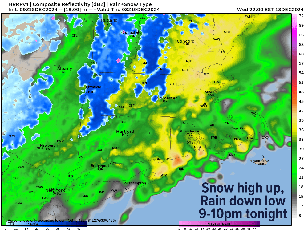
–Wet snow develops in the high terrain of southern VT, the central and northern Berkshires at elevation, and the western hilltowns of WMass this evening
–Snow may mix into the valley at times, but mostly rain is expected for much of WMass below 1000 feet elevation, much of CMass, and much of northern CT
–Southwest NH is a mix, some snow in eastern/northern parts, with rain mixing in over areas in/around Keene
–The Storm system responsible tracks across Long Island and through Nantucket, never strengthening much, with precip lasting between say 5pm and 1am
–A quarter inch to half inch of rain is expected, and a coating to 2” of snow in those aforementioned areas, with maybe 2-4” up in the spine of the southern Greens in VT
–Lows dip to the low to mid 30s, so watch for slippery spots in the high terrain either side of dawn on Thursday morning
–Colder air is drawn in by our passing system, and it will be breezy Thursday with highs in the mid 30s to low 40s with westerly gusts up to 25mph, and lows in the low to mid 20s with increasing clouds
–The shortwave and upper level system that will join forces off of our New England coast to graze the Cape with accumulating snow, and paste Nova Scotia with a snowy Nor’easter has to track through the greater WMass region Friday
–This likely will help develop a period of snow showers or light snow in parts of our region, and a coating to an inch is possible everywhere with highs in the low to mid 30s
–Snow showers may last into Friday evening, with lows in the 20s
–Behind this system, the Arctic empties into our region with highs in the mid to upper 20s Saturday, the teens on Sunday and 20s on Monday under partly to mostly sunny skies with lows in the single digits
–In fact wind chills by Sunday morning may be below zero, which is quite cold for December
–Lastly, while the early week rebounds a bit with temps, it’ll still be at least seasonably cold, and we may see a small storm system bring some light snow to us by Christmas Eve or Day, so I will keep you updated!
I hope you have a great day and if you want to combat the cold this Winter with my warm and cozy hoodies or long sleeves, just click below to browse & order:
Dave Hayes The Weather Nut Merch / Apparel (ends 12/22)
“Follow your bliss and the universe will open doors for you where there were only walls.”
― Joseph Campbell
