Still time to get one of the last-ever Weather Nut weather calendars:
(Final 2025 edition will sell out, first come first served)
~~~~~~~~~~~~~~~~~~~~~~
TABLE OF CONTENTS
* Daily Celestials (Sun/Moon Data)
* Sponsor Note
* Morning Discussion
* TIP: Scroll below for sections, or read all
~~~~~~~~~~~~~~~~~~~~~~
YOUR DAILY CELESTIALS
~~~~~~~~~~~~~~~~~~~~~~
STAR:
–OUR STAR ROSE AT: 7:08am this morning
–OUR STAR WILL SET AT: 4:18pm this evening
–TOTAL DAYLIGHT TIME: 9 hours and 10 minutes
MOON:
–OUR MOON WILL RISE AT: 1:03pm this afternoon
–MOON RISE DIRECTION: East
–OUR MOON WILL SET AT: 2:39am tomorrow morning
–MOON SET DIRECTION: West-Northwest
–MOON PHASE: Waxing Gibbous (70.7%)
~~~~~~~~~~~~~~~~~~~~~~
A NOTE FROM OUR SPONSOR
~~~~~~~~~~~~~~~~~~~~~~
Dave Hayes The Weather Nut is Sponsored by Individual Community Members, Patrons, and Tandem Bagel Company… No matter the weather, Tandem Bagel is always there for you at several valley locations to make your mornings brighter! With *New Pizza Bagels(!)*, along with bagels baked fresh daily (including Gluten-Free options), house-whipped cream cheese, coffee, and tons of lunch options, Tandem is the perfect quick stop for lunch, breakfast, or a coffee and bagel to go.
You can either 1) visit them in Easthampton, Northampton, Hadley, Florence, and/or West Springfield, 2) hire them to cater your next event, or 3) use their super-streamlined online ordering tool by visiting their website and clicking the “Catering” or “Order Online” links.
~~~~~~~~~~~~~~~~~~~~~~
YOUR MORNING DISCUSSION
~~~~~~~~~~~~~~~~~~~~~~
Good morning folks, there is a LOT to talk about, and I plan on posting a comprehensive storm update here by late afternoon, so for now I am going to rip through a litany of double—dashed points of saliency, as I’m bordering on being literally dizzy with the amount of weather info to convey in support of how dynamic this storm system is going to be:
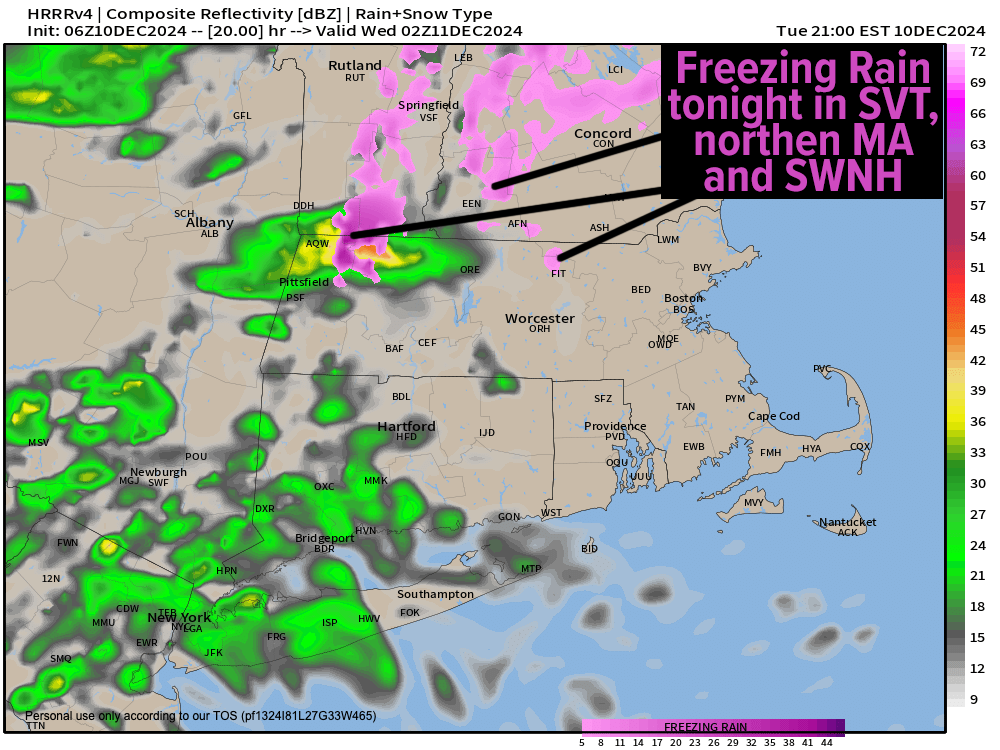
–Many areas in northern MA, central MA, southern VT and southwest NH are at or below freezing
–Therefore, freezing drizzle, freezing fog and black ice is expected, so be careful as you go outside, watch for slick spots
–Highs today under mostly cloudy skies will only reach to either side of 40º, so it will be raw, dreary, and a few showers are possible
–Showers start to build back in between 8pm-midnight tonight and with lows dipping into the mid 30s (and possibly the low 30s), some freezing rain showers are possible in northern MA, southern VT and southwest NH, with rain elsewhere
–A powerful, full-latitude upper trough (meaning that this area of lower pressures aloft extends the entire latitude of the United States from north to south, which is massive) will sweep east tonight and into Wednesday
–It will swing from a positive tilt (southwest to northeast) to more neutral (north to south) and be swinging negative (southeast to northwest) as it reaches New England
–This will draw a developing and sopping wet surface low from the southeast U.S. up the Hudson Valley of eastern NY Wednesday into Wednesday night
–Heavy rainfall will result with 1.5-4” expected Wednesday into Wednesday night
–Highs will soar well into the 50s and possibly even into the low 60s!
–Strong southerly winds will also develop, the mix-down of which to the surface will be aided by these expected milder surface temps)
–Stronger winds will be found further east of the I-91 corridor that you go, with gusts ranging from 25-50mph in the greater WMass region (strongest gusts in CMass and northeast CT)
–A strong to severe thunderstorm is possible in this dynamic environment and we can’t even rule out a brief spin-up with the amount of energy with this system (though that’s unlikely)
–Street flooding is expected, so clear your drains
–Flash Flood Watches are up for northwest CT, all of WMass and southern VT, with isolated flash flooding instances possible
–Scattered power outages are possible in the highlands of eastern Franklin / Hampden Counties as well as northeast CT and Worcester County up into eastern southwest NH
–And if all that weren’t enough, rain should flip back to wet snow in the Berkshires, far northwestern hilltowns of WMass and southern VT with a coating to 2” possible late Wednesday night into the pre-dawn of Thursday morning with lows diving 30º from Wednesday highs into the mid 20s to mid 30s! Dynamic!
–Westerly gusts of 25-40mph will pick up on Thursday behind the storm’s passage with drying conditions developing and mostly sunny skies with highs in the mid to upper 30s, and lows in the teens
–Friday and much of Saturday look dry and partly to mostly sunny, but cold in the 20s and 30s Friday and 30s on Saturday with clouds increasing
–More inclement weather with rain and snow is possible Sunday, but I will update that as we get closer
–For now I’m all hands, feet, eyes and brains on deck for our incoming tempest, and I will update again by this early evening
Have a great day, folks, and remember that I do still have a limited supply of 2025 weather calendars available, so if you want one or two, please click the secure link below to order…
HAIKU OF THE DAY
A gale rips northeast
Snow, thunder, wind and downpours
Tornado? Maybe.
“Follow your bliss and the universe will open doors for you where there were only walls.”
― Joseph Campbell
