[6:47AM SUN 12/8/24] THE MILDENING BEGINS… BREEZY / DRIER TODAY…. RAIN MOVES IN FOR MONDAY AFTERNOON WITH A WARM FRONT, SOME WINTRY PRECIP POSSIBLE ALONG AND NORTH OF THE RT. 2 CORRIDOR MONDAY EVE… MILDER TUESDAY AND WEDNESDAY… A FEW SHOWERSE TUESDAY, BUT WEDNESDAY BRINGS A SOAKING RAINFALL WITH STREET FLOODING POSSIBLE… MAY END AS BERKSHIRE / SVT SNOW WITH COATINGS IN THE PRE-DAWN OF THURSDAY MORNING… COLDER AND DRIER LATE WEEK INTO THE WEEKEND… DAVE’S LEFTOVER LIMITED SUPPLY OF FINAL 2025 WEATHER CALENDARS ARE NOW SELLING QUICKLY, GRAB 1 OR 2 BEFORE THEY’RE GONE…

(Final 2025 edition will sell out, first come first served)
~~~~~~~~~~~~~~~~~~~~~~
TABLE OF CONTENTS
* Daily Celestials (Sun/Moon Data)
* Sponsor Section
* Morning Discussion
* TIP: Scroll to your section, or read all
~~~~~~~~~~~~~~~~~~~~~~
YOUR DAILY CELESTIALS
~~~~~~~~~~~~~~~~~~~~~~
STAR:
–OUR STAR ROSE AT: 7:06am this morning
–OUR STAR WILL SET AT: 4:18pm this evening
–TOTAL DAYLIGHT TIME: 9 hours and 12 minutes
MOON:
–OUR MOON WILL RISE AT: 12:19pm this afternoon
–MOON RISE DIRECTION: East
–OUR MOON WILL SET AT: 12:09am tomorrow morning
–MOON SET DIRECTION: West
–MOON PHASE: Waxing Crescent (48.0%)
~~~~~~~~~~~~~~~~~~~~~~
>>> A NOTE FROM OUR WEEKEND SPONSOR <<<
Dave Hayes The Weather Nut is Sponsored by Individual Community Members, Patrons, and Gerard, Ghazey & Bates, P.C. GGBPC is a Northampton-based law firm regarded as the voice of pragmatic and well-reasoned estate planning, elder law and tax guidance in Western Massachusetts. The firm specializes in estate planning law, and expertly handles other matters such as Elder Law, Tax Law, as well as Real Estate purchase, sales, and refinance transactions. Contact GGBPC today to see how they can help!
~~~~~~~~~~~~~~~~~~~~~~
YOUR MORNING DISCUSSION
~~~~~~~~~~~~~~~~~~~~~~
Good morning folks, our 2nd Clipper system brought the light accumulating snow overnight, with 2” measured in Northampton. Please let me know how much you got!
We do have one final band of light to at times moderate snow moving through parts of the greater WMass region (SVT, SWNH, WMass, CMass, N.CT) before 8am, then we should be drying out and brightening our skies. Temps will come up into the upper 30s to mid 40s with partial sunshine by afternoon. West winds should gust 15-25mph as well behind our lil’ Clipper’s departure.
For tonight, lows will settle down into the upper 20s, so any melting that does occur today will freeze back up, so watch for slick spots due to black ice late tonight and early Monday morning.
Monday starts off dry, but a warm front will be approaching our region. Highs again will reach the upper 30s to mid 40s, and rain showers will arrive by afternoon into the evening.
It’s possible that it will precipitate steadily enough along with a secondary low developing along the front (primary low will pass well north of us) that some dynamic cooling could produce a mix with snow north of of the Rt. 2 corridor.
In addition, high pressure will be set up over Maine and that may help to bleed/drain some cold surface air down into SWNH, far northern MA and SVT to produce pockets of freezing rain Monday night, so I will keep updating on this Monday night wintry potential. Lows will dip to the low to mid 30s.
Behind the front for Tuesday, we get even milder, with highs well into the 40s on Tuesday, and then well into the 50s (for a day) on Wednesday!
Lingering showers Tuesday morning should give way to a mostly cloudy day with a few isolated showers possible. Tuesday night lows will hang in the upper 30s as rain pushes into the region from the southwest.
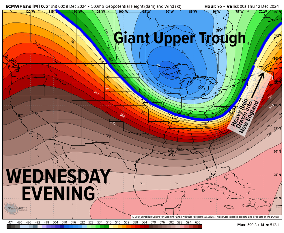
A large, deep and potent upper level trough will span from the Dakotas into New England, and its core will dig south into the western Appalachians, helping to draw a surface low pressure system with copious moisture from the southeast U.S. up the eastern seaboard on Wednesday into Wednesday night.
This will produce an expansive area of moderate to heavy rainfall that will soak the greater WMass region, and we can’t rule out street flooding potential as well as isolated flash flooding, though I think the street flooding is more likely what plays out.
So, expect a mild, breezy, and very rainy Wednesday into Wednesday night, with cold air sweeping in from west to east as the storm passes our latitude.
This could flip us from rain to snow in the Berkshires, western hilltowns, northern Litchfield Hills and southern VT, laying down a quick slushy inch of snow before the system pulls away early Thursday morning.
Behind that storm, we will cool back down, and dry out for sure.
Thursday through Saturday look colder with highs in the 30s and lows in the teens and 20s with partly to mostly sunny skies, and no big storms in sight through the upcoming weekend.
Have a great day, folks, and remember that I do still have a limited supply of 2025 weather calendars available, so if you want one or two, please click the secure link below to order… I will get them out quickly.
HAIKU OF THE DAY
Winter weather ruled
This first week of December
Most happy, I’ve been
“Follow your bliss and the universe will open doors for you where there were only walls.”
― Joseph Campbell
