DAVE’S 2024 APPAREL SALE (Two Designs, great holiday gifts)
#1. Snow Lover’s Triangle of Disappointment
https://www.bonfire.com/wmass-snow-lovers-triangle-2024
#2. Classic DHTWN Logo Design
https://www.bonfire.com/classic-dhtwn-logo-2024/
~~~~~~~~~~~~~~~~~~~~~~
TABLE OF CONTENTS
* Daily Celestials (Sun/Moon Data)
* Sponsor Section
* Morning Discussion
* TIP: Scroll to your section, or read all
~~~~~~~~~~~~~~~~~~~~~~
YOUR DAILY CELESTIALS
~~~~~~~~~~~~~~~~~~~~~~
STAR:
–OUR STAR ROSE AT: 6:58am this morning
–OUR STAR WILL SET AT: 4:19pm this evening
–TOTAL DAYLIGHT TIME: 9 hours and 21 minutes
MOON:
–OUR MOON WILL SET AT: 3:34pm this afternoon
–MOON SET DIRECTION: Southwest
–OUR MOON WILL RISE AT: 7:40am tomorrow morning
–MOON RISE DIRECTION: Southeast
–MOON PHASE: Waning Crescent (36.0%)
~~~~~~~~~~~~~~~~~~~~~~
>>> A NOTE FROM OUR WEEKEND SPONSOR <<<
Dave Hayes The Weather Nut is Sponsored by Individual Community Members, Patrons, and Gerard, Ghazey & Bates, P.C. GGBPC is a Northampton-based law firm regarded as the voice of pragmatic and well-reasoned estate planning, elder law and tax guidance in Western Massachusetts. The firm specializes in estate planning law, and expertly handles other matters such as Elder Law, Tax Law, as well as Real Estate purchase, sales, and refinance transactions. Contact GGBPC today to see how they can help!
~~~~~~~~~~~~~~~~~~~~~~
YOUR MORNING DISCUSSION
~~~~~~~~~~~~~~~~~~~~~~
Good morning folks, a number of us in the region are waking up to a fresh coating to 2” or so of snow, which was the result stronger-than-expected snow showers and squalls with a wave that kicked up as it crossed the region late afternoon yesterday into the early evening.
My report will continue below, but while we’re here, I wanted to repost snow totals pulled together by Skywarn Coordinator Rob Macedo who frequents this page. Check the Thanksgiving Day totals below, and yesterday’s snow squall accumulations:
PRELIMINARY SNOWFALL REPORTS – 11/29/24
1000 PM: Sterling, MA: 0.5″
953 PM: Spencer, MA: Coating (Roads wet)
950 PM: West Hawley, MA: 3.0″
950 PM: Hubbardston, MA: 0.1″
950 PM: Leicester, MA: Coating/Trace (At Spencer line)
940 PM: Haydenville, MA: 1.0″
930 PM: Gill, MA: 0.8″
930 PM: Millers Falls, MA: Coating/Trace
925 PM: Ashfield, MA: 2.0″
925 PM: North Ashburnham, MA: 1.5″ (Roads snow covered)
915 PM: Huntington, MA: 1.0″
910 PM: Charlemont, MA: 1.5
805 PM: Athol, MA: 0.3″
720 PM: Otis, MA: 3.0″
720 PM: Ashfield, MA: 1.0″
715 PM: West Hawley, MA: 3.0″
715 PM: Savoy, MA: 3.0″
715 PM: Plainfield, MA: 3.0″
THANKSGIVING 2024 SNOWFALL REPORTS – 11/28/24:
945 AM: Hawley, MA: 10.1″ (Co-Op Observer)
700 AM: Colrain, MA: 5.5″
910 PM: Heath, MA: 8.0″
552 PM: Hawley, MA: 9.5″ (Co-Op Observer)
425 PM: Chesterfield, MA: 3.0″
400 PM: Savoy, MA: 6.0″
330 PM: Rowe, MA: 6.0″
235 PM: Conway, MA: 2.0″ (Elevation 1000 feet)
225 PM: Heath, MA: 7.0″
200 PM: Colrain, MA: 5.0″
150 PM: Worthington, MA: 5.0″ (At the Cummington town line)
130 PM: West Hawley, MA: 5.0″ (West Hill – Elevation: 1500 feet)
1205 PM: Ashfield MA: 2.5″ (Elevation: 1500 feet)
1200 PM: Worthington MA: 4.0″ (at Cummington town line)
1200 PM: Plainfield MA: 6.0″ (at the savoy town line – 1700 foot elevation)
1145 AM: Heath MA: 6.0″ (1700 foot elevation)
1145 AM: Colrain MA: 5.0″
1145 AM: Middlefield MA: 3.0″
1140 AM: Charlemont MA: 4.0″
1135 AM: Plainfield MA: 4.0″
1135 AM: Goshen MA: 3.0″
(Curated and produced by Rob Macedo (KD1CY)
Eastern Massachusetts ARES Section Emergency Coordinator & SKYWARN Coordinator)
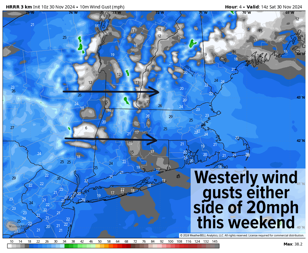
As for our weather going forward, this weekend looks breezy, dry with more clouds than sun today, but with some sunny periods. Highs will sit mostly in the 30s with a few spots reaching 40º. Lows will be unseasonably cold, down into the teens to low 20s.
For Sunday, highs may not crest 30º in far northwest MA into SVT and SWNH, and hang in the 30s elsewhere, with continued westerly breezes, and more sunshine. Lows will be colder, only in the mid to upper teens. Any breezes will make it feel colder as well.
Monday through Wednesday looks partly sunny in the high terrain, and mostly sunny in the valley south and east, with highs in the mid 20s to low 30s at elevation, and firmly in the 30s in the valley south and east. Lows will plummet into the teens throughout this period.
So much for our unseasonable warm spurts not that long ago!!
If you live in New England, just wait a minute remains true…
By Wednesday afternoon, clouds should be increasing as an Alberta Clipper system dives southeast towards northern New England.
Alberta Clippers are moisture-starved, land-based, Canadian-prairie-sourced storm systems that are born in the cold season, and tend to provide “pretty up the place” type of light snowfalls, as I call it.
We haven’t seen many of them over the recent years, and this one’s “energy” (again, they are fairly weak) will be centered more north of us, but a coating to 2” looks possible at this range Wednesday night into Thursday.
Behind this system, even colder air is set to blast into our region as thet ridge out west continues, producing a trough in the east, allowing northwest flow through Canada and into New England.
Highs next weekend may only reach the 20s with lows in the single digits!!
Have a great day, and before the sale ends Monday be sure to bundle up and pick up some of my warm hoodies and/or long-sleeves (or a 2025 weather calendar, if you need one), at the secure links below, your support keeps my reports churning, thank you:
***Warm and Cozy 2024 Apparel Sale Ends Monday***
#1. Snow Lover’s Triangle of Disappointment
https://www.bonfire.com/wmass-snow-lovers-triangle-2024
#2. Classic DHTWN Logo Design
https://www.bonfire.com/classic-dhtwn-logo-2024/
#3. 2025 Weather Wall Calendar
(Securely Order via Cards, Venmo, PayPal, Check)
https://westernmassweather.com/product/2025-dhtwn-weather-wall-calendar/
“Follow your bliss and the universe will open doors for you where there were only walls.”
― Joseph Campbell
