[7:07AM MON 11/18/24] RAIN STILL EXPECTED FOR THURSDAY… EARLY MORNING SHOWERS TODAY LEAD TO A GUSTIER AFTERNOON, FIRE-SPREAD RISK CONTINUES… FAIR, SUNNY CONDITIONS TUESDAY AND WEDNESDAY… UNSETTLED WEATHER DEVELOPS LATE WEEK INTO SATURDAY WITH RAIN, AND POTENTIAL FOR ELEVATION WET SNOW… STEADIER RAIN THURSDAY, MORE SHOWERY FRIDAY INTO POSSIBLY the FIRST PART OF SATURDAY… SUNDAY IS WEEKEND PICK… COOLER TEMPS EXPECTED THURSDAY FORWARD…

TABLE OF CONTENTS
* Daily Celestials (Sun/Moon Data)
* Sponsor Note
* Morning Discussion
* TIP: Scroll below for sections, or read all
~~~~~~~~~~~~~~~~~~~~~~
YOUR DAILY CELESTIALS
~~~~~~~~~~~~~~~~~~~~~~
STAR:
–OUR STAR ROSE AT: 6:44am this morning
–OUR STAR WILL SET AT: 4:26pm this evening
–TOTAL DAYLIGHT TIME: 9 hours and 42 minutes
MOON:
–OUR MOON WILL SET AT: 10:11am this morning
–MOON SET DIRECTION: Northwest
–OUR MOON WILL RISE AT: 6:40pm this evening
–MOON RISE DIRECTION: Northeast
–MOON PHASE: Full Beaver Supermoon (90.8%)
~~~~~~~~~~~~~~~~~~~~~~
A NOTE FROM OUR SPONSOR
~~~~~~~~~~~~~~~~~~~~~~
Dave Hayes The Weather Nut is Sponsored by Individual Community Members, Patrons, and Tandem Bagel Company… No matter the weather, Tandem Bagel is always there for you at several valley locations to make your mornings brighter! With *New Pizza Bagels(!)*, along with bagels baked fresh daily (including Gluten-Free options), house-whipped cream cheese, coffee, and tons of lunch options, Tandem is the perfect quick stop for lunch, breakfast, or a coffee and bagel to go.
You can either 1) visit them in Easthampton, Northampton, Hadley, Florence, and/or West Springfield, 2) hire them to cater your next event, or 3) use their super-streamlined online ordering tool by visiting their website and clicking the “Catering” or “Order Online” links.
~~~~~~~~~~~~~~~~~~~~~~
DHTWN ANNOUNCEMENTS
~~~~~~~~~~~~~~~~~~~~~~
— Dave’s FREE Mobile App launches in December
— Get updates at the link below
~~~~~~~~~~~~~~~~~~~~~~
YOUR MORNING DISCUSSION
~~~~~~~~~~~~~~~~~~~~~~
Good morning everybody, we have a weak frontal boundary bringing a few light showers through the region this morning.
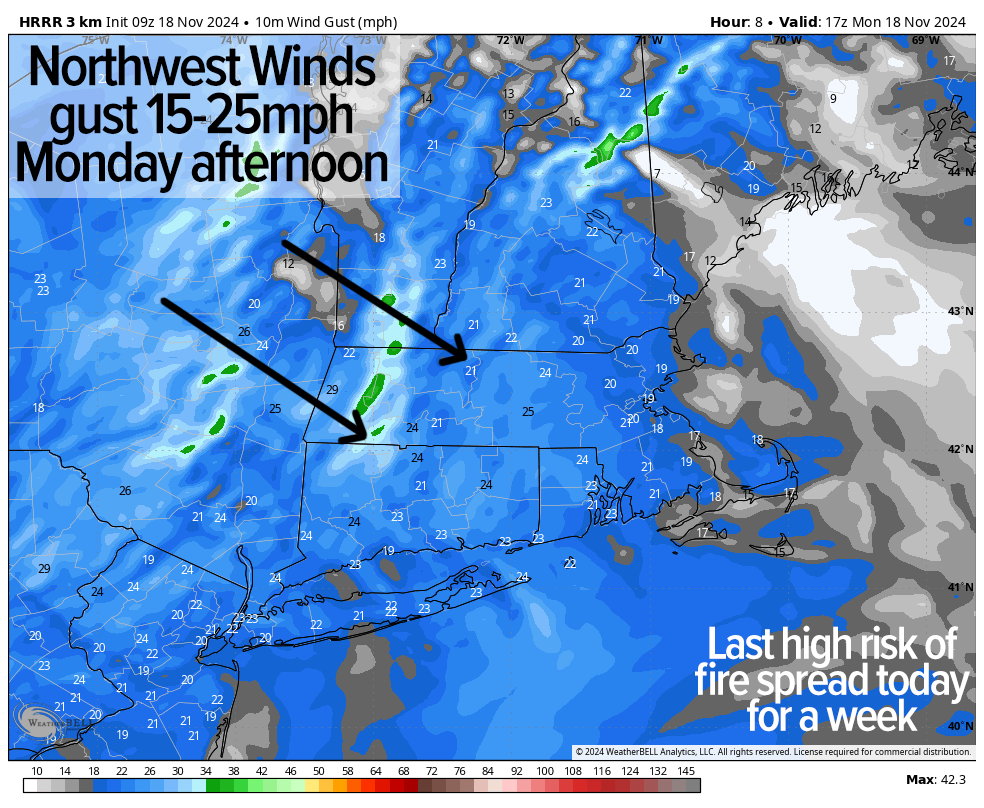
This will clear to the east of us and mostly sunny skies should develop by afternoon with mild highs in the mid 50s to low 60s. Northwest winds will kick up and gust 15-25mph behind the front, so once again an elevated risk of fire spread will be present for today and this evening.
Lows tonight will drop into the mid to upper 30s under partly cloudy skies with breezy conditions likely continuing.
High pressure moves closes to us Tuesday and certainly by Wednesday, with sunshine expected both days along with lighter wind and high temps rising into the 50s both days with lows in the low to mid 30s.
Tuesday night should feature mostly clear skies, but clouds will be building, lowering and thickening up Wednesday night in advance of our first real rainfall in many weeks.
We will see an anomalous upper level trough and low pressure system dive into the eastern Great Lakes and eventually into New England later this week.
There will be a primary surface low pressure system that sets up over the Ohio Valley and will extend a juicier warm front our way, along which a secondary low is likely to form near the NYC metro region by early Thursday.
This storm will strengthen and spread rainfall in our region by early Thursday morning, so expect a wet morning commute, the way it looks now.
Upper troughs bring not only unsettled conditions, but also cooler air, and that will be the case starting Thursday with highs only expected to rise into the mid to upper 40s.
Rain should continue Thursday night and with temps dropping into the low to mid 30s we could see a mix with or a flip to wet snow in the Berkshires, western hilltowns and southern VT overnight. In addition, minor wet snow accumulations are possible.
By Friday into Saturday, uncertainty develops as our upper low will be in the neighborhood, and the interaction between the primary and secondary surface low pressure systems is unknown at this time. Additional periods of scattered showers are more probable than not for Friday, Friday night into a part of Saturday with highs in the 40s both days.
However, details will have to be worked out as we get closer to the late week / weekend period. Sunday does look like the brightest of the two weekend days with no showers expected then, along with partial sunshine, but it still looks like cool temps will prevail with highs in the 45-50º range.
I will stay on top of it and keep you updated, and I hope you have a great day!
(Securely Order via Cards, Venmo, PayPal, Check)
“Follow your bliss and the universe will open doors for you where there were only walls.”
― Joseph Campbell
