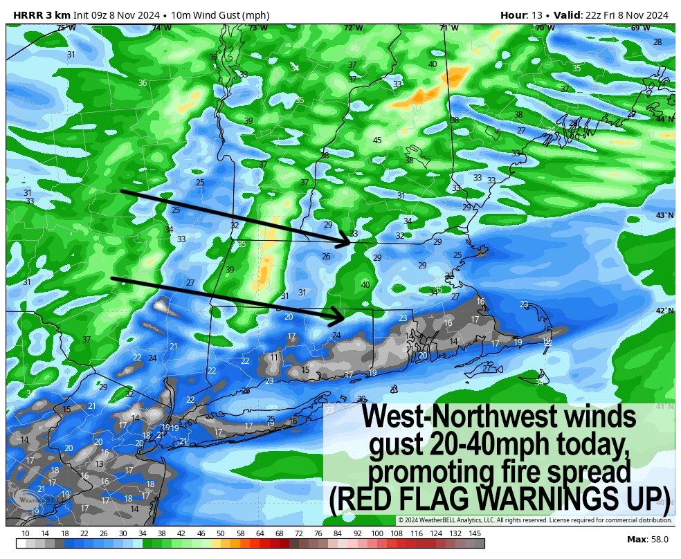
[7:10AM FRI 11/8/24] GUSTY WINDS HAVE PROMPTED HOISTING OF RED FLAG WARNINGS FOR WESTERN MA, CENTRAL MA, AND NORTHERN CT TODAY… WESTERLY WIND GUSTS 20-40MPH CAN EASILY SPREAD GROUND FIRES… COOLER SATURDAY, SUNNY… SHOWERS BY SUNDAY NIGHT… MILD MONDAY, COOLER AND FAIR THROUGH MID WEEK… LATE WEEK RAINSTORM POSSIBLE… LAST CALL TO ORDER MY LAST-EVER 2025 CALENDAR… SALE ENDS SUNDAY…

*** 3 Days Remain to order Dave’s final Calendar***
Dave’s greatest hits edition includes:
~ 12 Lovely Local Photos + Cover
~ Lots of Interesting Weather Lessons
~ 12 of my Best Weather-Themed Haiku
~ Much more including tons of celestial info, WMass storms, Holidays etc.
~~~~~~~~~~~~~~~~~~~~~~
TABLE OF CONTENTS
* Daily Celestials (Sun/Moon Data)
* Sponsor Note
* Morning Discussion
* TIP: Scroll below for sections, or read all
~~~~~~~~~~~~~~~~~~~~~~
YOUR DAILY CELESTIALS
~~~~~~~~~~~~~~~~~~~~~~
STAR:
–OUR STAR ROSE AT: 6:32am this morning
–OUR STAR WILL SET AT: 4:35pm this evening
–TOTAL DAYLIGHT TIME: 10 hours and 3 minutes
MOON:
–OUR MOON WILL RISE AT: 12:58pm this afternoon
–MOON RISE DIRECTION: East-Southeast
–OUR MOON WILL SET AT: 10:37pm tonight
–MOON SET DIRECTION: West-Southwest
–MOON PHASE: Waxing Crescent (42.1%)
~~~~~~~~~~~~~~~~~~~~~~
A NOTE FROM OUR SPONSOR
~~~~~~~~~~~~~~~~~~~~~~
Dave Hayes The Weather Nut is Sponsored by Individual Community Members, Patrons, and Tandem Bagel Company… No matter the weather, Tandem Bagel is always there for you at several valley locations to make your mornings brighter! With *New Pizza Bagels(!)*, along with bagels baked fresh daily (including Gluten-Free options), house-whipped cream cheese, coffee, and tons of lunch options, Tandem is the perfect quick stop for lunch, breakfast, or a coffee and bagel to go.
You can either 1) visit them in Easthampton, Northampton, Hadley, Florence, and/or West Springfield, 2) hire them to cater your next event, or 3) use their super-streamlined online ordering tool by visiting their website and clicking the “Catering” or “Order Online” links.
~~~~~~~~~~~~~~~~~~~~~~
DHTWN ANNOUNCEMENTS
~~~~~~~~~~~~~~~~~~~~~~
*Sale Ends This SUNDAY*
(Cards, Venmo, PayPal, Check)
~~~~~~~~~~~~~~~~~~~~~~
YOUR MORNING DISCUSSION
~~~~~~~~~~~~~~~~~~~~~~
Good morning everybody, moderate to severe drought conditions continue across the greater WMass region, and ahead of an incoming mostly dry cold frontal passage tonight, gusty winds will pick up and gust 20-40mph today, exacerbating and promoting rapid ground fire spread.
This is why Red Flag Warnings have been hoisted by the NWS for all of MA, CT and RI with elevated concerns for fire spread in SVT and SWNH as well.
Highs today ahead of the front will reach the upper 50s to mid 60s with partly to mostly sunny skies on the earlier side and clouds increasing from north to south by later afternoon as the front moves in with a few isolated showers.
For tonight, it will be blustery at times with wind still active and lows with cold air advection behind the front should drop into the low to mid 30s, with some upper 20s possible in SVT as skies clear late.
On Saturday, winds will be slowly slackening but could still gust over 20mph out of the northwest under mostly sunny skies with highs only reaching the mid 40s to low 50s, which is more seasonable as we head into the 2nd week of November.
Lows will be cold Saturday night as high pressure tracks east into the northern Mid-Atlantic region, calming winds, clearing skies, and allowing radiational cooling to max out and dip temps into the 20s.
A slight southwest flow develops Sunday with highs pushing into the mid to upper 50s under partly sunny skies early, but clouds will be developing as a system pushes in from the west, which will bring our first period of actual showers in weeks, arriving Sunday late afternoon into the night. Lows will hang in the 40s, and either side of a quarter inch of rain is possible by Monday morning.
After early showers Monday morning, skies will clear pretty rapidly as this progressive system and frontal boundary tracks east and away, and with high pressure south of us, highs will spike into the low to mid 60s for a day with developing sunshine.
However, that looks like our last shot at unseasonably mild air for a while, and as life is known to behave, everything changes.
Tuesday should feature Canadian high pressure and seasonable highs in the low to mid 50s with lows in the 30s along with fair weather each day/night.
By Thursday into Friday, we have a better chance at a legit rainstorm, which is much needed in our region given our drought conditions.
I will keep an eye on it and update you as we get closer, and while we’re here, I hope you’ll choose my final 2025 weather calendar for your holiday gift shopping, or for yourself, as people have really loved it over the past 10 years of publishing as the **sale ends this Sunday**, so just secure-click below and I’ll take care of you, thank you.
(Securely Order via Cards, Venmo, PayPal, Check)
“Follow your bliss and the universe will open doors for you where there were only walls.”
― Joseph Campbell
