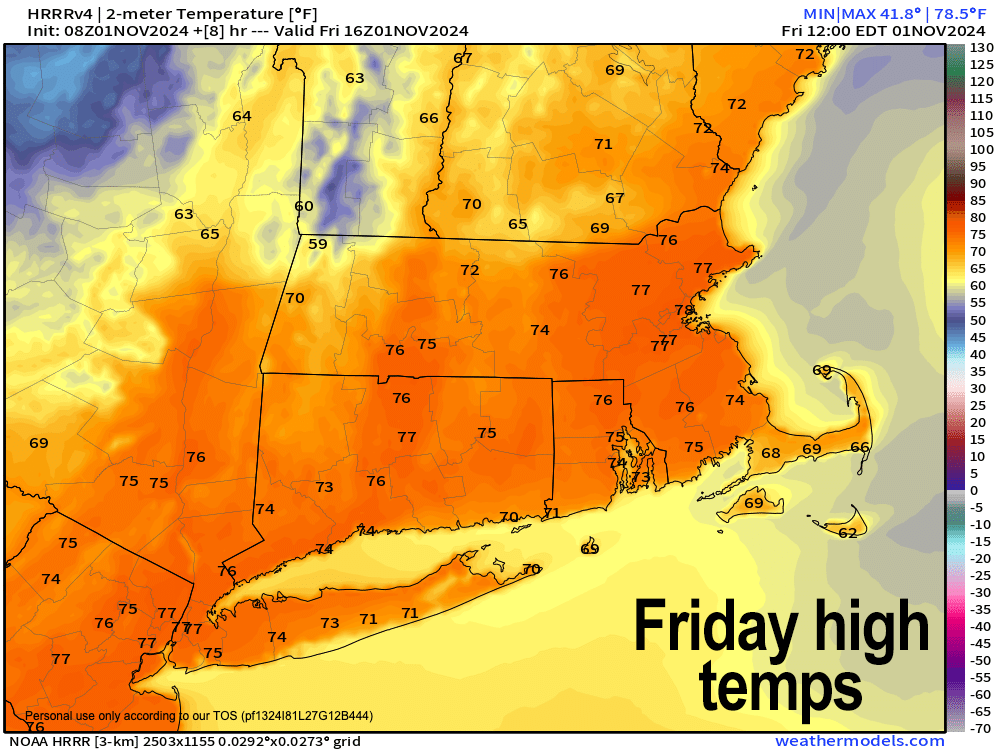
[7:07AM FRI 11/1/24] GUSTY WARM WESTERLIES TODAY, RED FLAG WARNINGS CONTINUE… PAUSE BURNS AND PUT OUT CIGS PROPERLY… HIGHS IN THE 70S FALL BACK TO THE 30S TONIGHT… FAIR AND SEASONABLY COOL WEEKEND WITH SATURDAY NIGHT FREEZE… MODERATE DROUGHT NOW IN EFFECT… WARMER EARLY TO MID NEXT WEEK… NO STORMS IN SIGHT…

***ONLY 9 DAYS REMAIN IN MY FINAL 2025 CALENDAR SALE***
~ An Affordable and Universal Holiday Gift Solution
~ 12 Lovely Local Photos + Cover
~ Lots of Interesting Weather Lessons
~ 12 of my Best Weather-Themed Haiku
~ Much more including tons of celestial info, WMass storms, Holidays etc.
~~~~~~~~~~~~~~~~~~~~~~
TABLE OF CONTENTS
* Daily Celestials (Sun/Moon Data)
* Sponsor Note
* Morning Discussion
* TIP: Scroll below for sections, or read all
~~~~~~~~~~~~~~~~~~~~~~
YOUR DAILY CELESTIALS
~~~~~~~~~~~~~~~~~~~~~~
STAR:
–OUR STAR ROSE AT: 7:23am this morning
–OUR STAR WILL SET AT: 5:43pm this evening
–TOTAL DAYLIGHT TIME: 10 hours and 20 minutes
MOON:
–OUR MOON WILL RISE AT: 7:33am this morning
–MOON RISE DIRECTION: East-Southeast
–OUR MOON WILL SET AT: 5:32pm this afternoon
–MOON SET DIRECTION: West-Southwest
–MOON PHASE: Waxing Crescent (0.1%)
~~~~~~~~~~~~~~~~~~~~~~
A NOTE FROM OUR SPONSOR
~~~~~~~~~~~~~~~~~~~~~~
Dave Hayes The Weather Nut is Sponsored by Individual Community Members, Patrons, and Tandem Bagel Company… No matter the weather, Tandem Bagel is always there for you at several valley locations to make your mornings brighter! With *New Pizza Bagels(!)*, along with bagels baked fresh daily (including Gluten-Free options), house-whipped cream cheese, coffee, and tons of lunch options, Tandem is the perfect quick stop for lunch, breakfast, or a coffee and bagel to go.
You can either 1) visit them in Easthampton, Northampton, Hadley, Florence, and/or West Springfield, 2) hire them to cater your next event, or 3) use their super-streamlined online ordering tool by visiting their website and clicking the “Catering” or “Order Online” links.
~~~~~~~~~~~~~~~~~~~~~~
DHTWN ANNOUNCEMENTS
~~~~~~~~~~~~~~~~~~~~~~
2025 Weather Wall Calendar *Sale Ends Nov. 10th*
(Click/Order via Cards, Venmo, PayPal, Check)
https://westernmassweather.com/product/2025-dhtwn-weather-wall-calendar/
~~~~~~~~~~~~~~~~~~~~~~
YOUR MORNING DISCUSSION
~~~~~~~~~~~~~~~~~~~~~~
Good morning folks, it is *very* mild out there this morning, with many in the low to mid 60s, and that will set the stage for one last warm day prior to a cold front swinging east and through the greater WMass region today.
Before the colder air arrives by mid to late afternoon and into tonight, highs will reach the mid to upper 60s in SVT and far northwest MA, and well into the 70s elsewhere in WMass, CMass, SWNH and northern CT.
By mid to late morning, westerly winds will pick up and gust 20-35mph today, with some gusts hitting or exceeding 40mph in some of our regional airport fields, or at elevation in the mountains and high hills.
Winds will continue tonight, but ramp down overnight into Saturday with lows dropping into the 30s to low 40s under mostly clear skies in the valley with partly to mostly cloudy skies in the western high terrain of the Berkshires, western hills and SVT.
For the weekend, high pressure will press east into our region, calm our winds, and bring cooling flow from Canada which will keep highs mainly in the 40s for the Berkshires, western hilltowns, SVT/SWNH, and upper 40s to mid 50s in the rest of WMass, CMass and northern CT.
Expect partly sunny skies in the western high terrain west of I-91 and mostly sunny skies in the valley south and east.
With very dry air, calm wind and clear skies Saturday night, radiational cooling maximizes and brings lows into the 25-30º range, with similar highs and mostly sunny skies on Sunday.
Clouds increase Sunday night with lows either side of 30º, as a warm front tries to extend northeast into our region and Monday’s highs will be similar to the weekend, in the 40s to low 50s under partly sunny to mostly cloudy skies.
The Tuesday-Wednesday period will feature some sort of frontal interaction which will bifurcate the region with warmer temps south and cooler temps north, in general.
Highs should climb into the 60s for many of us, but some emay hang in the upper 50s north while others are in the low 70s south, so I will refine this as we get closer.
A few showers are possible as well.
Have a great day, and please remember my calendar as you think about your holiday gift shopping, or for yourself (sale ends in 10 days on 11/10):
(Securely Order via Cards, Venmo, PayPal, Check)
“Follow your bliss and the universe will open doors for you where there were only walls.”
― Joseph Campbell
