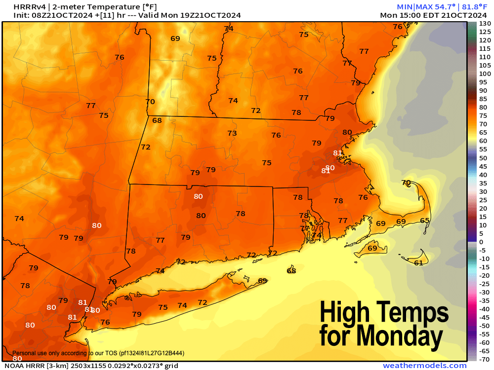
[6:52AM MON 10/21/24] A BALMY SUMMER REDUX FOR OUR MONDAY… SOME CREST 80º… WARM AND SUNNY THROUGH WEDNESDAY… A FEW SHOWERS INTO THURSDAY MORNING, WITH COOLER AIR RETURNING LATE WEEK INTO WEEKEND WITH A FEW SHOWERS POSSIBLE SATURDAY… NO BIG STORMS IN SIGHT AS DRY CONTINUES… THANK YOU TO MY 2025 CALENDAR CUSTOMERS: YOUR SUPPORT IS GREATLY APPRECIATED (SALE ENDS NOV. 10TH)…

~ Colorful Regional Photos & Weather Learnings
~ Affordable, Useful, & Practical
~ WMass Community-Oriented & Contemplative
~ Great for holiday gifts
~~~~~~~~~~~~~~~~~~~~~~
TABLE OF CONTENTS
* Daily Celestials (Sun/Moon Data)
* Sponsor Note
* DHTWN Announcements
* Morning Discussion
* TIP: Scroll below for sections, or read all
~~~~~~~~~~~~~~~~~~~~~~
YOUR DAILY CELESTIALS
~~~~~~~~~~~~~~~~~~~~~~
STAR:
–OUR STAR ROSE AT: 7:10am this morning
–OUR STAR WILL SET AT: 5:58pm this evening
–TOTAL DAYLIGHT TIME: 10 hours and 48 minutes
MOON:
–OUR MOON WILL SET AT: 12:28pm today
–MOON SET DIRECTION: Northwest
–OUR MOON WILL RISE AT: 8:54pm today
–MOON RISE DIRECTION: Northeast
–MOON PHASE: Waning Gibbous (79.1%)
~~~~~~~~~~~~~~~~~~~~~~
A NOTE FROM OUR SPONSOR
~~~~~~~~~~~~~~~~~~~~~~
Dave Hayes The Weather Nut is Sponsored by Individual Community Members, Patrons, and Tandem Bagel Company… No matter the weather, Tandem Bagel is always there for you at several valley locations to make your mornings brighter! With *New Pizza Bagels(!)*, along with bagels baked fresh daily (including Gluten-Free options), house-whipped cream cheese, coffee, and tons of lunch options, Tandem is the perfect quick stop for lunch, breakfast, or a coffee and bagel to go.
You can either 1) visit them in Easthampton, Northampton, Hadley, Florence, and/or West Springfield, 2) hire them to cater your next event, or 3) use their super-streamlined online ordering tool by visiting their website and clicking the “Catering” or “Order Online” links.
~~~~~~~~~~~~~~~~~~~~~~
DHTWN ANNOUNCEMENTS
~~~~~~~~~~~~~~~~~~~~~~
(Order via Cards, Venmo, PayPal, or Check)
~~~~~~~~~~~~~~~~~~~~~~
YOUR MORNING DISCUSSION
~~~~~~~~~~~~~~~~~~~~~~
Good morning folks, it’s gonna feel like early September today with a modest but balmy breezy west-southwest wind that will gust up to 20mph at times, sending highs into the low 70s in the high terrain to low 80s in the Pioneer Valley of WMass!
We may tie a rec\ord or two, but I don’t expect a big record-breaking day temperature-wise.
We can thank giant high pressure centered over the southern Ohio Valley down into Kentucky that is tracking east and “getting under us” to the south, which helps produce the warming southwest flow that usually drives summer conditions.
This time of year, we’re seeing the Canadian low pressure systems and troughs tracking east through southern Canada which are instigating the see-saw descent into the cold season with cooling northwest flow, and that will happen again after a cold frontal passage Wednesday night into Thursday morning with a few showers.
Prior to that, though, we’re mostly sunny with the aforementioned highs in the 70s to low 80s today, with lows tonight dropping into the upper 40s, followed by two more warm days with highs in the mid to upper 70s Tuesday and low to mid 70s Wednesday.
Monday night and Tuesday night look clear, with lows Tuesday night in the low 50s, but by Wednesday evening clouds will be building as a front approaches.
This front looks fairly moisture-starved down by our neck of the woods, but a few showers are expected Wednesday night into the first half of Thursday
We should develop sunshine by late morning into the afternoon on Thursday, but northwest winds may gust over 20mph at times as cooler air rushes in, dropping our highs down into the 55-60º range with lows in the low to mid 30s.
Friday should feature sunny skies and similar highs like Thursday, with milder lows in the upper 30s to low 40s.
Another frontal boundary could then swing through Saturday with a few showers as highs slightly rebound into the upper 50s to low 60s.
Behind the front, we drop back down into the upper 40s to mid 50s for highs with another good looking weekend at this range.
Enjoy the warmth over the next few days, have a great day, and please remember my calendar as you think about your holiday gift shopping, or for yourself (order link below):
(Securely Order via Cards, Venmo, PayPal, Check)
“Follow your bliss and the universe will open doors for you where there were only walls.”
― Joseph Campbell
