
Dave’s 2025 Weather Wall Calendar packs a lot of goodies into one best-of edition (click below to securely order):
~ Colorful Local Photos & Educational Content
~ WMass Community-Oriented & Contemplative
~ Affordable, Useful, & Practical
~ Great for holiday gifts (order info below)
~~~~~~~~~~~~~~~~~~~~~~
TABLE OF CONTENTS
* Daily Celestials (Sun/Moon Data)
* Sponsor Note
* DHTWN Announcements
* Morning Discussion
* TIP: Scroll below for sections, or read all
~~~~~~~~~~~~~~~~~~~~~~
YOUR DAILY CELESTIALS
~~~~~~~~~~~~~~~~~~~~~~
STAR:
–OUR STAR ROSE AT: 7:02am this morning
–OUR STAR WILL SET AT: 6:09pm this evening
–TOTAL DAYLIGHT TIME: 11 hours and 7 minutes
MOON:
–OUR MOON WILL RISE AT: 4:52pm today
–MOON RISE DIRECTION: East
–OUR MOON WILL SET AT: 4:31am tomorrow
–MOON SET DIRECTION: West
–MOON PHASE: Waxing Gibbous (86.4%)
~~~~~~~~~~~~~~~~~~~~~~
A NOTE FROM OUR SPONSOR
~~~~~~~~~~~~~~~~~~~~~~
Dave Hayes The Weather Nut is Sponsored by Individual Community Members, Patrons, and Tandem Bagel Company… No matter the weather, Tandem Bagel is always there for you at several valley locations to make your mornings brighter! With *New Pizza Bagels(!)*, along with bagels baked fresh daily (including Gluten-Free options), house-whipped cream cheese, coffee, and tons of lunch options, Tandem is the perfect quick stop for lunch, breakfast, or a coffee and bagel to go.
You can either 1) visit them in Easthampton, Northampton, Hadley, Florence, and/or West Springfield, 2) hire them to cater your next event, or 3) use their super-streamlined online ordering tool by visiting their website and clicking the “Catering” or “Order Online” links.
~~~~~~~~~~~~~~~~~~~~~~
DHTWN ANNOUNCEMENTS
~~~~~~~~~~~~~~~~~~~~~~
1. 2025 DHTWN Weather Wall Calendar
(Securely Order via Cards, Venmo, PayPal, or Check)
2. Dave’s Mobile Weather App by December
~~~~~~~~~~~~~~~~~~~~~~
YOUR MORNING DISCUSSION
~~~~~~~~~~~~~~~~~~~~~~
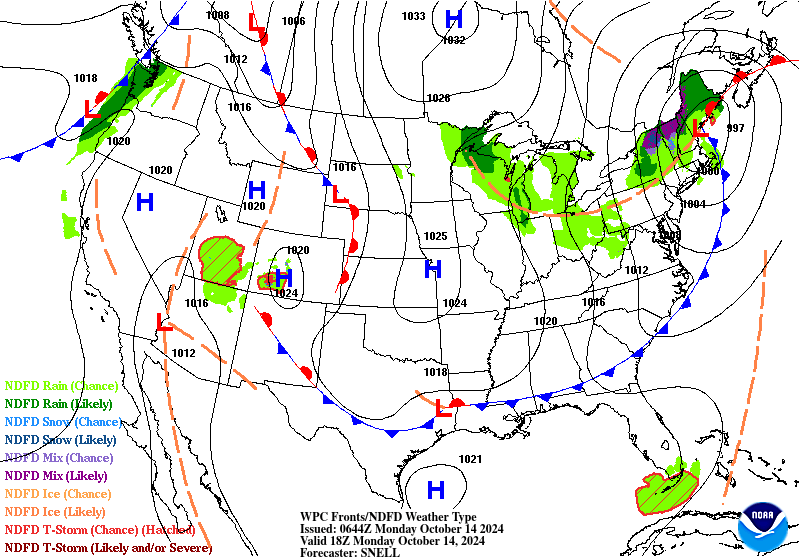
Good morning everybody, many of us north of the Pike in MA, SVT and SWNH had a nice drink of rain yesterday and overnight, and even a few thunderclaps!
Apparently I had hypnotized myself into a sonorous snore-fest, because wake I did not, but I’ve heard that others were not so fortunate, most likely including some poor pooches who weren’t very happy, I imagine.
As for our weather going forward today, we have a cold front that will sweeping through the region and kicking most of the rainfall out of the greater WMass region by early afternoon.
However, as colder air moves in at all levels, a period of showers may develop later this afternoon and run through part of WMass, SVT and SWNH, with the best chance of getting wet in Berkshire, Hampshire and Franklin Counties into northern CMass and SVT/SWNH.
In fact, I can’t rule out some snow or sleet mixing into southern VT toward sunset!
Highs will reach the upper 40s north and west to the upper 50s south and east, and west to northwest winds will gust later today and tonight between 20-35mph as temps drop to the low to mid 30s overnight, so it’ll be COLD tonight for mid-October as clearing develops later.
For Tuesday and Wednesday, we’ll still be under the influence of an upper low swinging east of the Great Lakes with cool highs in the upper 40s to mid 50s, and lows in the low to mid 30s, with some upper 20s possible by Wednesday night in SVT.
Skies will be partly to mostly sunny in the valley points south and east, and mostly cloudy to partly sunny in the high terrain of the Berkshires, SVT, SWNH and the western hilltowns, generally speaking.
A wave of energy will pass southeast through the region Tuesday night, and it is at that time that some upslope snow showers could set up over SVT, and MAYBE bleed down into and kiss far northwest MA as well.
In fact, we could see some light snow accumulations in the high peaks of southern VT by early Wednesday morning.
Thursday looks mostly sunny for everybody as the upper low tracks east and away from New England, which will produce highs in the mid to upper 50s with lows in the low to mid 30s under clear skies for one more frosty night before we warm up through the weekend AND into next week.
While our upper low is coming east, so is a giant sprawling high pressure system that will park itself over the east coast by Friday.
This should produce sunny days and clear nights, and as the high moves south of us, our wind direction will become more west to west-southwest, which will warm us up.
Friday’s highs should reach the mid to upper 60s, and through the weekend highs should climb into the upper 60s to low 70s, with lows in the upper 30s to mid 40s.
This may last into the first half of the following week as well!
Suffice it to say, this upcoming weekend (at this range) is looking amazing, with a tranquil week ahead after the next 24 hours when our final showers move through and the air gets vacuumed from high pressure west of us to low pressure east of us.
Have a great day, and please remember me for your holiday gift shopping, or if you need a calendar (order link below)!
2025 DHTWN Weather Wall Calendar
(Securely Order via Cards, Venmo, PayPal, or Check)
“Follow your bliss and the universe will open doors for you where there were only walls.”
― Joseph Campbell