Dave’s 2025 Weather Wall Calendar packs a lot of goodies into one piece:
~ Colorful Local Photos & Educational Content
~ WMass Community-Oriented
~ Affordable, Useful, & Practical
~ Great for holiday gifts (order info below)
2025 Weather Nut Wall Calendar
(Securely Order via Cards, Venmo, PayPal, Check)
~~~~~~~~~~~~~~~~~~~~~~
TABLE OF CONTENTS
* Daily Celestials (Sun/Moon Data)
* Sponsor Section
* Morning Discussion
* TIP: Scroll to your section, or read all
~~~~~~~~~~~~~~~~~~~~~~
YOUR DAILY CELESTIALS
~~~~~~~~~~~~~~~~~~~~~~
STAR:
–OUR STAR ROSE AT: 7:00am this morning
–OUR STAR WILL SET AT: 6:12pm this evening
–TOTAL DAYLIGHT TIME: 11 hours and 12 minutes
MOON:
–OUR MOON WILL RISE AT: 3:58pm this morning
–MOON RISE DIRECTION: East-Southeast
–OUR MOON WILL SET AT: 1:53am tomorrow morning
–MOON SET DIRECTION: Southwest
–MOON PHASE: Waxing Gibbous (68.4%)
~~~~~~~~~~~~~~~~~~~~~~
>>> A NOTE FROM OUR WEEKEND SPONSOR <<<
Dave Hayes The Weather Nut is Sponsored by Individual Community Members, Patrons, and Gerard, Ghazey & Bates, P.C. GGBPC is a Northampton-based law firm regarded as the voice of pragmatic and well-reasoned estate planning, elder law and tax guidance in Western Massachusetts. The firm specializes in estate planning law, and expertly handles other matters such as Elder Law, Tax Law, as well as Real Estate purchase, sales, and refinance transactions. Contact GGBPC today to see how they can help!
~~~~~~~~~~~~~~~~~~~~~~
YOUR MORNING DISCUSSION
~~~~~~~~~~~~~~~~~~~~~~
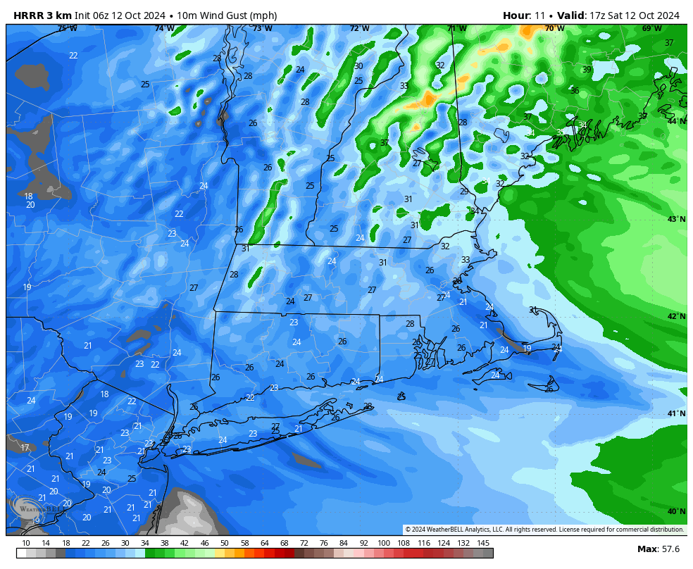
Good morning everybody, the cold front is passing through the region with northwest wind gusting 20-35mph, and that will continue into much of the day, abating later this evening.
Mild highs will reach the low to mid 60s with some upper 60s possible, though areas like SVT and far northwest MA may struggle to hit 60º.
It will be a mostly sunny, autumnal day for sure, and again windier in the high terrain with some leaves blowing around.
For tonight, temps drop quickly with lows possibly dipping to the low to mid 30s prior to clouds increasing as a warm front approaches the region from the southwest extending east off of an incoming storm system out of the Ohio Valley.
If showers arrive early enough, some snow could mix in over southern VT or far northwest MA (northern Berkshires, western Franklin County), but mostly rain showers are expected Sunday with steadiest rain along and north of thee Pike, with less rain down into northern CT.
———————
LARRY PICARD RE: DAVE’S WMASS WEATHER CALENDAR
“Thoughtful, beautiful, and the essence of what makes western Mass what it is. Dave’s calendar is the perfect wall calendar and supports one of the things we love best about western Massachusetts: Dave Hayes and his accurate, colorful, and entertaining weather reports.” Click to order…
———————
Highs Sunday will only reach the mid to upper 40s!! Cool and raw day tomorrow.
Lows will also hang in the low 40s, although there’s a low chance for a few more snowflakes to mix in over SVT by early Monday morning.
The storm will track from the Ohio Valley through southernmost New England and off into eastern Maine on Monday so while most of the steadier rain should end Monday, I think the influence of the incoming upper low will continue scattered shower potential through Monday morning, until showers abate by sometime in the afternoon.
Highs Monday will reach the low to mid 50s with lows in the 30s as lake effect showers are generated and may dot the Berkshires or SVT with some mixed rain or snow showers.
Tuesday and Wednesday looks chilly with partly sunny skies and highs in the mid 40s to low 50s, along with potential for a shortwave to swing through Tuesday night and deliver some upslope rain or snow showers to the western high terrain.
By Thursday and Friday temps should come up a bit, but highs shouldn’t exceed the 50s, to perhaps low 60s by end of the week with fair weather expected.
Have a great day!
2025 DHTWN Weather Wall Calendar
(Securely Order via Cards, Venmo, PayPal, or Check)
HAIKU OF THE DAY:
Colored lights rained down
Aurora Borealis
Space storm delivered
“Follow your bliss and the universe will open doors for you where there were only walls.”
― Joseph Campbell
