Dave’s 2025 Weather Wall Calendar packs a lot of goodies into one best-of edition (click below to securely order):
~ Colorful Local Photos & Educational Content
~ WMass Community-Oriented & Contemplative
~ Affordable, Useful, & Practical
~ Great for holiday gifts (order info below)
~~~~~~~~~~~~~~~~~~~~~~
TABLE OF CONTENTS
* Daily Celestials (Sun/Moon Data)
* Sponsor Note
* DHTWN Announcements
* Morning Discussion
* TIP: Scroll below for sections, or read all
~~~~~~~~~~~~~~~~~~~~~~
YOUR DAILY CELESTIALS
~~~~~~~~~~~~~~~~~~~~~~
STAR:
–OUR STAR ROSE AT: 6:59am this morning
–OUR STAR WILL SET AT: 6:14pm this evening
–TOTAL DAYLIGHT TIME: 11 hours and 15 minutes
MOON:
–OUR MOON WILL RISE AT: 3:25pm this morning
–MOON RISE DIRECTION: Southeast
–OUR MOON WILL SET AT: 12:36am this evening
–MOON SET DIRECTION: West-Southwest
–MOON PHASE: Waxing Gibbous (57.2%)
~~~~~~~~~~~~~~~~~~~~~~
A NOTE FROM OUR SPONSOR
~~~~~~~~~~~~~~~~~~~~~~
Dave Hayes The Weather Nut is Sponsored by Individual Community Members, Patrons, and Tandem Bagel Company… No matter the weather, Tandem Bagel is always there for you at several valley locations to make your mornings brighter! With *New Pizza Bagels(!)*, along with bagels baked fresh daily (including Gluten-Free options), house-whipped cream cheese, coffee, and tons of lunch options, Tandem is the perfect quick stop for lunch, breakfast, or a coffee and bagel to go.
You can either 1) visit them in Easthampton, Northampton, Hadley, Florence, and/or West Springfield, 2) hire them to cater your next event, or 3) use their super-streamlined online ordering tool by visiting their website and clicking the “Catering” or “Order Online” links.
~~~~~~~~~~~~~~~~~~~~~~
DHTWN ANNOUNCEMENTS
~~~~~~~~~~~~~~~~~~~~~~
1. 2025 DHTWN Weather Wall Calendar
(Securely Order via Cards, Venmo, PayPal, or Check)
2. News on Dave’s Upcoming Mobile Weather App
(Late 2024 Release)
~~~~~~~~~~~~~~~~~~~~~~
YOUR MORNING DISCUSSION
~~~~~~~~~~~~~~~~~~~~~~
Good morning everybody, we’re starting off quite chilly with a few low 30s readings, but mostly in the mid 30s to low 40s with some patchy frost, I’d imagine, please let me know if you frosted overnight.
And thanks so much for all of those amazing Aurora pics last night, going out just after twilight turned out to be the right call as that is when it peaked last night, glad so many of you caught it!!
There is some potential for it to happen again tonight, as geomagnetic storming continues this morning, but I will update later as I’m honestly unsure what the likelihood for viewing is tonight.
As for our weather, we’ve got a pair of milder days on the way thanks to high pressure and upper ridging moving to our south through the Mid-Atlantic, creating a more zonal (i.e. west to east) flow which should push highs today into the low to mid 60s under mostly sunny skies with west winds gusting over 20mph at times.
For tonight, we should see partly cloudy to mostly clear skies, with more partly cloudy skies the further north you go as a cold front sweeps into northern New England.
With winds still up a bit, temps should hang in the mid to upper 40s overnight, so it will be milder.
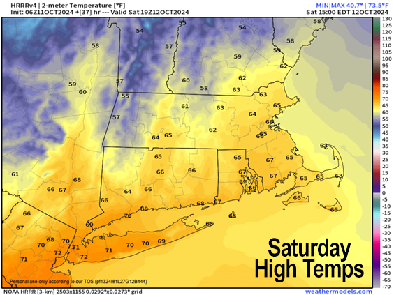
For Saturday, a frontal boundary will cross the region during the morning, and northwest winds should kick up behind it, gusting 20-35mph at times, so it will be windier day than today.
Because colder air will be lagging, and move in Saturday night, our highs on Saturday should enjoy a downsloping / warming effect from the wind, and push our temps up into the mid to upper 60s under mostly sunny skies before falling late in the day.
Lows will plummet Saturday night as colder air moves into the region on northwest flow, dropping into the mid to upper 30s with some patchy frost possible, although clouds will be building in late, so frost potential may be limited.
By Sunday, a warm front will be floating northeast into our region, connected to a storm that will be sweeping out of the northern Ohio Valley and southern Great Lakes region into NY state, destined for northern New England by Monday.
This warm front will introduce first showers into the greater WMass region by Sunday afternoon, with some showers possible in the morning.
We’ll remain on the cool side of the warm front, with highs only in the 50s, and Sunday afternoon and night looks like rainy at the moment, especially north of the Pike.
Low temps will drop into the 40s with periods of showers continuing, which should last into Monday, with an uncertain end time at the moment.
For now, a good part of Monday looks showery, with highs only in the mid to upper 50s, with rain quitting late, and lows dropping into the 30s with strong northwest flow developing as the storm sweeps northeast into northern New England we get on its back side where northwest flow will be generated and pulled into our region.
The Tuesday through Thursday period looks to be mostly dry with much colder highs in the upper 40s to mid 50s Tuesday and Wednesday, and firmly in the 50s by Thursday, with lows in the low to mid 30s with frost or even a freeze possible.
The other note I wanted to make is that behind our Monday storm system, the lake effect machine will turn on for the first time this Autumn, and as such NY state will see periods of scattered rain and even some snow showers.
All this to say, don’t be surprised if parts of southern VT, the Taconics of eastern NY and the northern Berkshires or even northwest hilltowns see first snowflakes mixed in with any instability showers that survive the trip here from the Great Lakes!
Have a great day, and remember me for your holiday gift shopping, or if you need a calendar (order link below)!
2025 DHTWN Weather Wall Calendar
(Securely Order via Cards, Venmo, PayPal, or Check)
“Follow your bliss and the universe will open doors for you where there were only walls.”
― Joseph Campbell
